File:Persian(IRAN) Empire 1747.jpg
Aller à la navigation
Aller à la recherche
Taille de cet aperçu : 715 × 600 pixels. Autres résolutions : 286 × 240 pixels | 572 × 480 pixels | 915 × 768 pixels | 1 220 × 1 024 pixels | 2 441 × 2 048 pixels | 5 420 × 4 548 pixels.
Fichier d’origine (5 420 × 4 548 pixels, taille du fichier : 8,38 Mio, type MIME : image/jpeg)
Légendes
Légendes
Ajoutez en une ligne la description de ce que représente ce fichier
Description[modifier]
| Description |
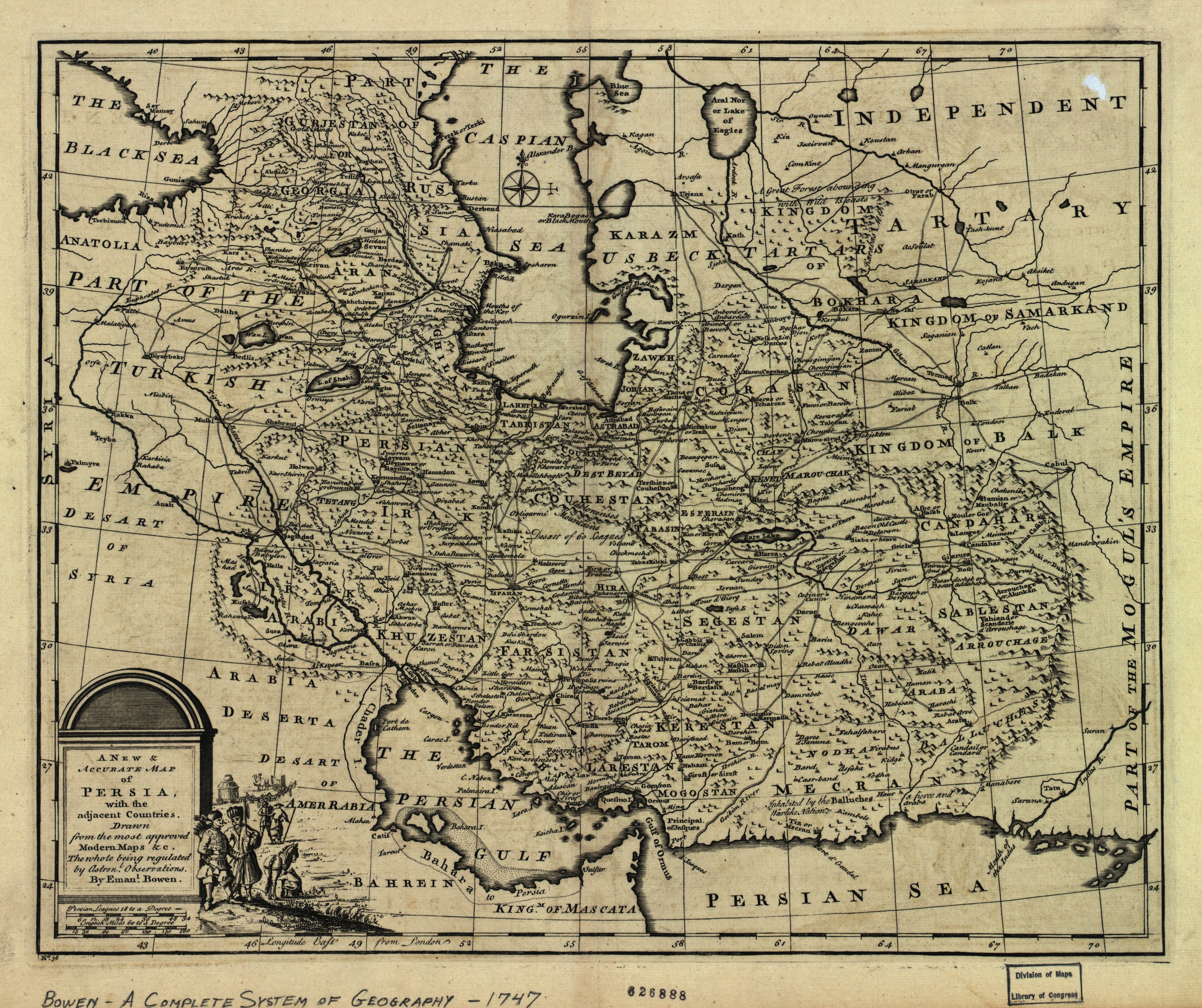
English: The map of the Persian Empire in 1747 at the time of Afsharid Dynasty. a complete system of geography.
فارسی: نقشهٔ امپراطوری ایران در سال ۱۷۴۷ میلادی برابر با ۱۱۲۶ خورشیدی و ۱۱۶۰ قمری در زمان دودمان افشاریان |
|||||||||||||||||||||||
| Date | vers 1750 | |||||||||||||||||||||||
| Source | http://memory.loc.gov/ | |||||||||||||||||||||||
| Auteur |
|
|||||||||||||||||||||||
| Autres versions |
Œuvres dérivées de ce fichier : |
|||||||||||||||||||||||

_Empire_1747.jpg&action=edit§ion=1)
_Empire_1747_(A).JPG)
_Empire_1747_(B).JPG)
|
_Empire_1747.jpg)
Conditions d’utilisation[modifier]
_Empire_1747.jpg&action=edit§ion=2)
|
Ceci est une reproduction photographique fidèle d'une œuvre d'art originale en deux dimensions. L'œuvre d'art elle-même est dans le domaine public pour la raison suivante :
La position officielle de la Fondation Wikimedia est que « les représentations fidèles des œuvres d'art du domaine public en deux dimensions sont dans le domaine public et les exigences contraires sont une attaque contre le concept même de domaine public ». Pour plus de détails, voir Commons:Quand utiliser le bandeau PD-Art.
Cette reproduction photographique est donc également considérée comme étant élevée dans le domaine public. Merci de noter qu'en fonction des lois locales, la réutilisation de ce contenu peut être interdite ou restreinte dans votre juridiction. Voyez Commons:Reuse of PD-Art photographs. | ||||
Historique du fichier
Cliquer sur une date et heure pour voir le fichier tel qu'il était à ce moment-là.
| Date et heure | Vignette | Dimensions | Utilisateur | Commentaire | |
|---|---|---|---|---|---|
| actuel | 9 juillet 2012 à 18:21 | | 5 420 × 4 548 (8,38 Mio) | Paris 16 (d | contributions) | e |
| 31 août 2008 à 15:40 |  | 5 664 × 4 715 (7,22 Mio) | Wayiran (d | contributions) | {{Information |Description={{en|1=The map of the Persian Empire in 1747 at the time of Afsharid Dynasty}} {{fa|1=نقشهٔ امپراطوری ایران در سال ۱۷۴۷ میلادی برابر با ۱۱۲۶ خورشیدی و ۱۱۶۰ قمری در � |
Vous ne pouvez pas remplacer ce fichier.
Utilisations locales du fichier
Les 7 pages suivantes utilisent ce fichier :
- Commons:Featured picture candidates/File:Persian(IRAN) Empire 1747.jpg
- Commons:Featured picture candidates/Log/July 2012
- File:Aras River in Persian (IRAN) Empire 1747 map.JPG
- File:Caspian sea in Persian (IRAN) Empire 1747.JPG
- File:Persian(IRAN) Empire 1747 (A).JPG
- File:Persian(IRAN) Empire 1747 (B).JPG
- File:گیلان در نقشه امپراطوری افشاریه سال 1747 میادی.jpg
_Empire_1747.jpg)
_Empire_1747_map.JPG)
_Empire_1747.JPG)
Utilisations du fichier sur d’autres wikis
Les autres wikis suivants utilisent ce fichier :
- Utilisation sur azb.wikipedia.org
- Utilisation sur ckb.wikipedia.org
- Utilisation sur de.wikipedia.org
- Utilisation sur diq.wikipedia.org
- Utilisation sur en.wikipedia.org
- Utilisation sur eo.wikipedia.org
- Utilisation sur et.wikipedia.org
- Utilisation sur fa.wikipedia.org
- دریای عمان
- خلیج فارس
- مشهد
- تاریخ ایران
- نادرشاه
- شهرستان میانه
- میانه (آذربایجان شرقی)
- ایران بزرگ
- ایران افشاری
- نقشهنگاری
- تاریخ ارمنستان
- تحریف نام خلیج فارس
- جغرافیای تاریخی ایران
- ویکیپدیا:گزیدن نگاره برگزیده/دسامبر-۲۰۱۱
- ویکیپدیا:نگارههای برگزیده/نقشه
- ویکیپدیا:نگاره روز/آوریل ۲۰۱۲
- نقشه ایران در دوره افشاریه
- ویکیپدیا:گزیدن نگاره برگزیده/Persian(IRAN) Empire 1747.jpg
- الگو:نر/2012-04-06
- بحث کاربر:Alborzagros/بایگانی ۴
- الگو:نر محافظت شده/2012-04-06
- نقشههای کهن
- ارمنستان ایران (۱۵۰۲–۱۸۲۸)
- فهرست سلسلههای ایران
- بحث:آذربایجان/بایگانی ۲
- Utilisation sur fa.wikibooks.org
- Utilisation sur fr.wikipedia.org
- Utilisation sur hi.wikipedia.org
- Utilisation sur it.wikipedia.org
- Utilisation sur ja.wikipedia.org
_Empire_1747.jpg)
Voir davantage sur l’utilisation globale de ce fichier.
_Empire_1747.jpg)
_Empire_1747.jpg&oldid=715740845)