File:Peterborough East Shed - Geograph-5228768-by-Paul-Bryan.jpg

Original file (4,000 × 3,000 pixels, file size: 5.01 MB, MIME type: image/jpeg)
Captions
Captions
Summary[edit]
| Description |
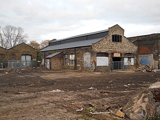
English: Victorian engine shed at the former Peterborough East Station This Grade II listed Victorian engine shed was part of the former Peterborough East station, which was opened by the Eastern Counties Railway (ECR) in June 1845. As the city's first railway station, it was initially known simply as Peterborough until being renamed Peterborough East in July 1923. Passenger services on the line to Northampton were discontinued in May 1964 and freight services from Peterborough East were terminated in April 1966. The remaining passenger services on the route to Rugby were withdrawn in June 1966 although the station continued to serve as a parcel depot until December 1970. The site was proposed in 1971 as a possible location for the National Railway Museum (although this was eventually located in York, opening in 1975). The station building was demolished in 1972. The turntable was acquired by the Nene Valley Railway (NVR) in 1977 and moved to Wansford, leaving the engine shed plus adjacent goods sheds and a section of the main platform as the only remaining structures. The Peterborough to Ely line, which runs past the site, is still in use. The engine sheds are earmarked for conversion as part of a redevelopment of the Fletton Quays area of the city costing £120 million (GBP 120 million) and involving the construction of riverfront residential properties, offices and leisure facilities. |
| Date | |
| Source | Geograph.org.uk |
| Author | Paul Bryan |
| Attribution (required by the license) | Paul Bryan / Victorian engine shed at the former Peterborough East Station / |
| Camera location | | View this and other nearby images on: OpenStreetMap |
|---|
_region:GB-ENG_heading:45.00&language=en)
| Object location | | View this and other nearby images on: OpenStreetMap |
|---|
_region:GB-ENG_heading:45.00&language=en)
Licensing[edit]

|
This image was taken from the Geograph project collection. See this photograph's page on the Geograph website for the photographer's contact details. The copyright on this image is owned by Paul Bryan and is licensed for reuse under the Creative Commons Attribution-ShareAlike 2.0 license.
|
- You are free:
- to share – to copy, distribute and transmit the work
- to remix – to adapt the work
- Under the following conditions:
- attribution – You must give appropriate credit, provide a link to the license, and indicate if changes were made. You may do so in any reasonable manner, but not in any way that suggests the licensor endorses you or your use.
- share alike – If you remix, transform, or build upon the material, you must distribute your contributions under the same or compatible license as the original.
File history
Click on a date/time to view the file as it appeared at that time.
| Date/Time | Thumbnail | Dimensions | User | Comment | |
|---|---|---|---|---|---|
| current | 23:35, 2 November 2020 | | 4,000 × 3,000 (5.01 MB) | Lamberhurst (talk | contribs) | =={{int:filedesc}}== {{Information |description={{en|1=<b>Victorian engine shed at the former Peterborough East Station</b><br>This Grade II listed Victorian engine shed was part of the former Peterborough East station, which was opened by the Eastern Counties Railway (ECR) in June 1845. As the city's first railway station, it was initially known simply as Peterborough until being renamed Peterborough East in July 1923. Passenger services on the line to Northampton were discontinued in May 19... |
You cannot overwrite this file.
File usage on Commons
The following page uses this file: