File:Petit atlas pittoresque - 07. 1er arrondissement - Quartier des Champs-Élysées. No. 2 - David Rumsey.jpg
Jump to navigation
Jump to search

Size of this preview: 798 × 599 pixels. Other resolutions: 320 × 240 pixels | 639 × 480 pixels | 1,023 × 768 pixels | 1,280 × 961 pixels | 2,560 × 1,923 pixels | 8,692 × 6,528 pixels.
Original file (8,692 × 6,528 pixels, file size: 16.17 MB, MIME type: image/jpeg)
Captions
Captions
Add a one-line explanation of what this file represents
Summary
[edit]
| Title |
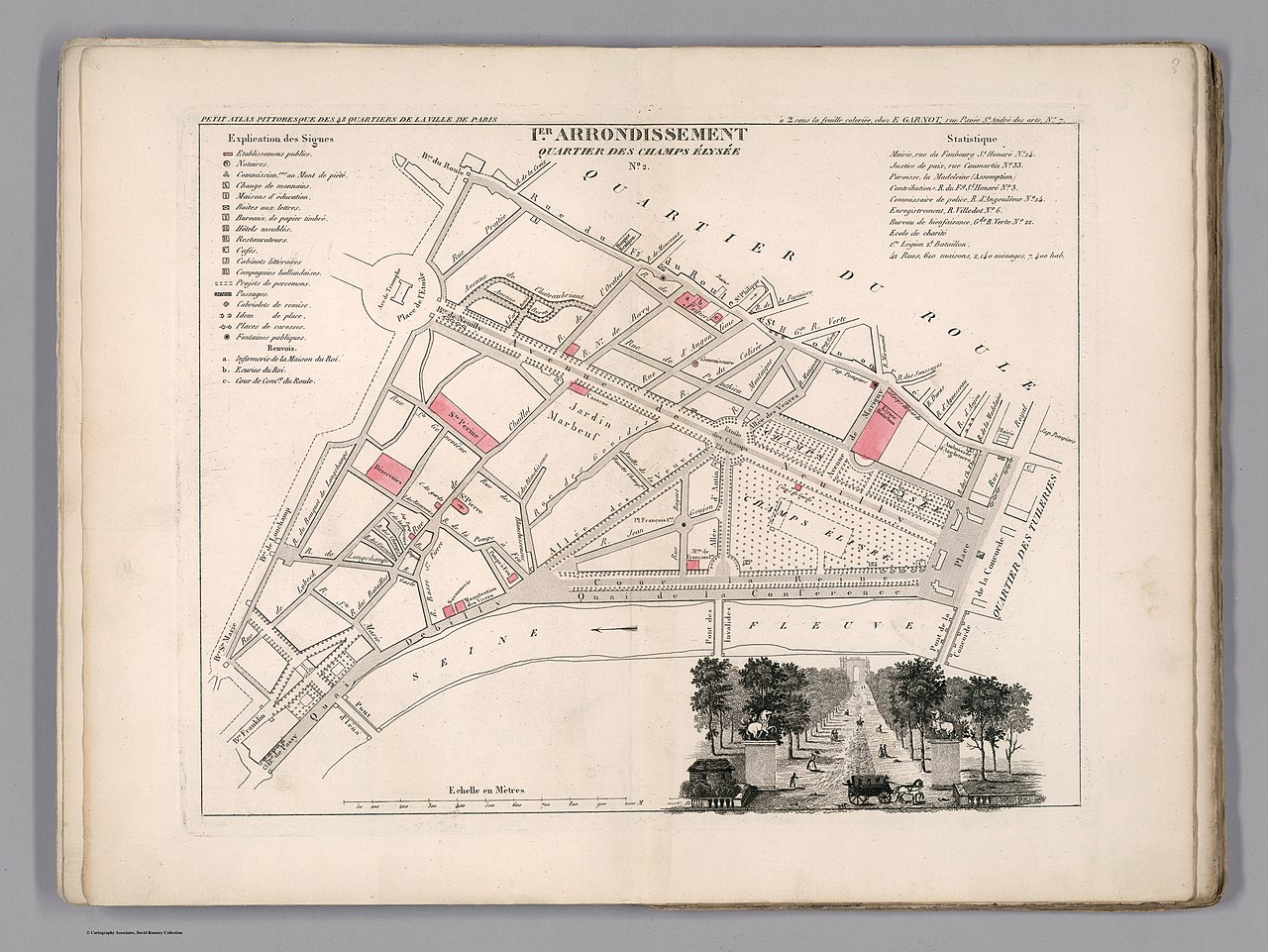
Petit atlas pittoresque des quarante-huit quartiers de la ville de Paris; Par A. M. Perrot, Engenieur. A Paris, Chez E. Garnot, Libraire, Rue Pavee Saint-Andre des Arcs,No. 7. 1834. |
| Description |
English: Engraved hand colored plan of 1 st. Borough, Faubroug du Roule, administrative district of Paris, with view of the Church of Saint -Philioppe du Roule. Shows roads, streets, monuments, city blocks, public buildings, etc. Includes explanation to symbols on the map and statistical table.
This is the first edition of an extremely uncommon atlas of the forty-eight districts of the city of Paris. Includes 50 color maps, a manuscript index and 48 pages of index to the neighborhoods and districts. Bound in green paper covers, with title "Petit atlas pittoresque des 48 quartiers de la ville de Paris, avec un tableau d'assemblage. Par A.-M. Perrot, Ingenieur." pasted on the cover. |
| Date | |
| Source | David Rumsey Historical Map Collection |
| Creator |
Aristide-Michel Perrot |
| Geotemporal data | |
| Map location | Paris |
| Georeferencing | If inappropriate please set warp_status = skip to hide. |
| Bibliographic data | |
| Place of publication | Paris |
| Publisher |
E. Garnot |
| Archival data | |
| Collection | David Rumsey Historical Map Collection |
| Medium | Atlas map |
Licensing
[edit]
|
This work is in the public domain in its country of origin and other countries and areas where the copyright term is the author's life plus 100 years or fewer. | |
| This file has been identified as being free of known restrictions under copyright law, including all related and neighboring rights. | |
File history
Click on a date/time to view the file as it appeared at that time.
| Date/Time | Thumbnail | Dimensions | User | Comment | |
|---|---|---|---|---|---|
| current | 14:37, 18 January 2020 | | 8,692 × 6,528 (16.17 MB) | Paris 16 (talk | contribs) | User created page with UploadWizard |
You cannot overwrite this file.
File usage on Commons
There are no pages that use this file.
File usage on other wikis
The following other wikis use this file:
- Usage on de.wikipedia.org
- Usage on fr.wikipedia.org
Metadata
Categories:
- Maps of Paris from the David Rumsey Historical Map Collection
- Petit atlas pittoresque des 48 quartiers de la ville de Paris, David Rumsey Historical Map Collection
- Paris former 1er arrondissement
- Quartier des Champs-Élysées
- Old maps of Paris 8e arrondissement
- Street maps of Paris 8e arrondissement
- Avenue des Champs-Élysées in the 1830s