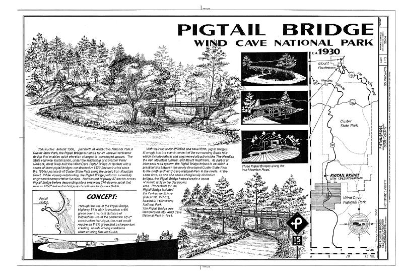
File:Pigtail Bridge, Hot Springs, Fall River County, SD HAER SD-54 (sheet 1 of 3).tif
Jump to navigation
Jump to search
Size of this JPG preview of this TIF file: 800 × 543 pixels. Other resolutions: 320 × 217 pixels | 640 × 434 pixels | 1,024 × 695 pixels | 1,280 × 869 pixels | 2,560 × 1,737 pixels | 14,459 × 9,811 pixels.
Original file (14,459 × 9,811 pixels, file size: 1.79 MB, MIME type: image/tiff)
Captions
Captions
Add a one-line explanation of what this file represents
Summary[edit]
| Warning | The original file is very high-resolution. It might not load properly or could cause your browser to freeze when opened at full size. |
|---|
| HAER SD-54 (sheet 1 of 3) - Pigtail Bridge, Hot Springs, Fall River County, SD | ||||
|---|---|---|---|---|
| Title |
HAER SD-54 (sheet 1 of 3) - Pigtail Bridge, Hot Springs, Fall River County, SD |
|||
| Description |
Norbeck, Peter; South Dakota State Highway Commission; Gray, Chris, field team project manager; Magdalenos, Christine, landscape architect; Marston, Christopher, project manager; Christianson, Justine, transmitter; Tichi, Claire, historian; Davis, Tim, historian; Delyea, Todd, delineator; Grinstead, Tim, delineator; Heckaman, Stacey, delineator; Michel, Roger, delineator; Haas, David, photographer |
|||
| Depicted place | South Dakota; Fall River County; Hot Springs | |||
| Date | Documentation compiled after 1968 | |||
| Dimensions | 24 x 36 in. (D size) | |||
| Current location |
Library of Congress Prints and Photographs Division Washington, D.C. 20540 USA http://hdl.loc.gov/loc.pnp/pp.print |
|||
| Accession number |
HAER SD-54 (sheet 1 of 3) |
|||
| Credit line |
|
|||
| Notes |
|
|||
| References |
|
|||
| Source | https://www.loc.gov/pictures/item/sd0081.sheet.00001a | |||
| Permission (Reusing this file) |
|
|||

File history
Click on a date/time to view the file as it appeared at that time.
| Date/Time | Thumbnail | Dimensions | User | Comment | |
|---|---|---|---|---|---|
| current | 23:00, 1 August 2014 |  | 14,459 × 9,811 (1.79 MB) | Fæ (talk | contribs) | GWToolset: Creating mediafile for Fæ. HABS 2014-08-01 (3201:3400) |
You cannot overwrite this file.
File usage on Commons
The following page uses this file: