File:Pinelli-Walckenaer Atlas (p. 3).jpg
Jump to navigation
Jump to search

Size of this preview: 800 × 536 pixels. Other resolutions: 320 × 215 pixels | 640 × 429 pixels | 1,024 × 687 pixels | 1,280 × 858 pixels | 2,560 × 1,716 pixels | 4,000 × 2,682 pixels.
Original file (4,000 × 2,682 pixels, file size: 4.79 MB, MIME type: image/jpeg)
Captions
Captions
Add a one-line explanation of what this file represents
Summary
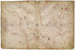
[edit]| English: Nautical chart of Western Europe, ca. 1400–1425.
( |
|
|---|---|
| Artist |
Anonymous Venetian cartographer. |
| Title |
English: Nautical chart of Western Europe, ca. 1400–1425. |
| Description |
English: The third sheet of the seven-sheet Pinelli-Walckenaer Atlas, a set of Italian portolan charts, depicting the west Mediterranean and north Atlantic coast, including the British Isles (it is oriented with West on top). |
| Date | Dated 1384, although in reality possibly made a little later, c. 1385–1410, and with additions from c. 1434. |
| Medium | Ink and tempera on parchment. |
| Dimensions | height: 29.4 cm (11.5 in); width: 45 cm (17.7 in). |
| Collection | |
| Current location | |
| Accession number |
Additional M.S. 19510, folios 2v-3. |
| References | [1]. |
| Source/Photographer | [2]. |

.jpg&action=edit§ion=1)
![[2]](http://ogimages.bl.uk/images/001/001ADD000019510U00002VRB%5BSVC2%5D.jpg)
Licensing
[edit].jpg&action=edit§ion=2)
|
This work is in the public domain in its country of origin and other countries and areas where the copyright term is the author's life plus 100 years or fewer. | |
| This file has been identified as being free of known restrictions under copyright law, including all related and neighboring rights. | |
File history
Click on a date/time to view the file as it appeared at that time.
| Date/Time | Thumbnail | Dimensions | User | Comment | |
|---|---|---|---|---|---|
| current | 06:40, 29 March 2012 | | 4,000 × 2,682 (4.79 MB) | Aavindraa (talk | contribs) | large res |
| 10:21, 15 July 2011 |  | 976 × 654 (315 KB) | Walrasiad (talk | contribs) | {{Information |Description ={{en|1=The second and third sheets of the seven-sheet Pinelli-Walckenaer Atlas, a set of Italian portolan charts, made by an anonymous Venetian cartographer. The atlas is explicitly dated 1384 (although possibly actually mad |
You cannot overwrite this file.
File usage on Commons
The following 2 pages use this file:
.jpg&redirect=no)
.jpg)
File usage on other wikis
The following other wikis use this file:
- Usage on ca.wikipedia.org
- Usage on en.wikipedia.org
- Usage on fr.wikipedia.org
.jpg&oldid=742016258)