File:Piri reis world map 01.jpg
跳转到导航
跳转到搜索

本预览的尺寸:449 × 599像素。 其他分辨率:180 × 240像素 | 360 × 480像素 | 576 × 768像素 | 768 × 1,024像素 | 1,964 × 2,619像素。
原始文件 (1,964 × 2,619像素,文件大小:7.08 MB,MIME类型:image/jpeg)
说明
说明
添加一行文字以描述该文件所表现的内容
摘要
[编辑]
|
| 描述 |
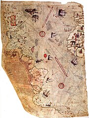
العربية: خارطة العالم بِيد أمير البحار العُثماني حاجي أحمد مُحيي الدين پیري، الشهير باسم پيري ريِّس، رُسمت سنة 1513م. لم يبقَ اليوم سوى نصف الخارطة الأصليَّة، التي يُحتفظ بها في متحف سراي طوپ قاپي في إسطنبول. تجمع هذه الخارطة معلومات من حوالي عشرين خريطة أُخرى، بما فيها إحدى الخرائط التي وضعها كريستوفر كولومبوس بنفسه وخطط فيها سواحل العالم الجديد.
English: Map of the world by Ottoman admiral Piri Reis, drawn in 1513. Only part of the original map survives and is held at the Topkapi Museum in Istanbul. The map synthesizes information from many maps, including one drawn by Christopher Columbus of the Caribbean.
Türkçe: Osmanlı amirali Piri Reis tarafından 1513'te çizilmiş olan, Avrupa ve Afrika'nın batı kıyılarıyla Güney Amerika'nın doğu kıyılarını gösteren dünyanın en eski haritalarından biri olan Piri Reis'in ilk Dünya haritası. |
| 日期 | |
| 来源 | Library of Topkapi Palace Museum, No. H 1824 Bilkent University (lo res), erisi.com (hi res) |
| 作者 |

许可协议
[编辑]
|
这是一个平面公有领域艺术品的忠实摄影副本。原艺术品本身因为下列原因属于公有领域:
维基媒体基金会的官方立场认为:“对平面公有领域艺术品的忠实再制作品也属于公有领域。”
因此,可以认为此摄影副本在美国也属于公有领域。在其他司法管辖区,再利用此内容可能存在限制;参见再利用PD-Art照片了解详细信息。 | ||||
| 注解 | 该图片含有注解:在维基媒体共享资源上查看注解 |
文件历史
点击某个日期/时间查看对应时刻的文件。
| 日期/时间 | 缩略图 | 大小 | 用户 | 备注 | |
|---|---|---|---|---|---|
| 当前 | 2017年7月17日 (一) 23:16 | | 1,964 × 2,619(7.08 MB) | Earthsound(留言 | 贡献) | Reverted to version as of 04:00, 17 August 2012 (UTC) The higher resolution images that replaced this are horribly pixelated and have been created by enlarging a much smaller copy. |
| 2016年11月13日 (日) 12:45 |  | 3,387 × 4,807(2.16 MB) | Alonso de Mendoza(留言 | 贡献) | color | |
| 2016年3月5日 (六) 13:19 |  | 3,387 × 4,807(1.6 MB) | ديفيد عادل وهبة خليل 2(留言 | 贡献) | Cropped 5 % horizontally and 5 % vertically using CropTool with precise mode. | |
| 2014年11月23日 (日) 10:37 |  | 3,564 × 5,040(1,019 KB) | Ratzer(留言 | 贡献) | higher Resolution 3564 x 5040, source http://www.erisi.com/gelisim/harita/pri/piri_dunya.jpg | |
| 2012年8月17日 (五) 04:00 |  | 1,964 × 2,619(7.08 MB) | FunkMonk(留言 | 贡献) | ||
| 2008年2月10日 (日) 02:45 |  | 2,000 × 2,753(2.27 MB) | FunkMonk(留言 | 贡献) | {{Information |Description= |Source= |Date= |Author= |Permission= |other_versions= }} | |
| 2006年9月13日 (三) 14:45 |  | 829 × 1,087(205 KB) | InfoCan(留言 | 贡献) | rotated previous version of map so North is up. | |
| 2005年9月29日 (四) 07:09 |  | 1,087 × 829(338 KB) | CristianChirita(留言 | 贡献) | Piri Reis World Map |
您不可以覆盖此文件。
文件用途
以下11个页面使用本文件:
- Map
- Old maps
- Topkapı Sarayı
- User:4ing/Antarctica/2016-03
- User:4ing/Antarctica/2016-11
- User:4ing/Antarctica/2017-07
- User:OgreBot/Watercraft/2016 November 13
- Commons:Featured picture candidates/Image:Piri reis world map 01.jpg
- File:Ottoman Barca from Piri Reis' Kitab-ı Bahriye.jpg
- File:Ottoman Barca from Piri Reis' World Map.jpg
- Category:Maps by Piri Reis
全域文件用途
以下其他wiki使用此文件:
- ar.wikipedia.org上的用途
- جزر الأنتيل
- قائمة اختراعات المسلمين في العصور الوسطى
- بوابة:الدولة العثمانية/صورة
- ويكيبيديا:صور مختارة/رسومات وجداول وخرائط/خرائط
- بيري ريس
- خريطة بيري ريس
- ويكيبيديا:ترشيحات الصور المختارة/خريطة أحمد محيي الدين امريكا
- ويكيبيديا:صورة اليوم المختارة/مايو 2016
- قالب:صورة اليوم المختارة/2016-05-23
- بوابة:الدولة العثمانية/صورة مختارة/19
- ويكيبيديا:صورة اليوم المختارة/أغسطس 2017
- قالب:صورة اليوم المختارة/2017-08-22
- ويكيبيديا:صورة اليوم المختارة/يوليو 2019
- قالب:صورة اليوم المختارة/2019-07-23
- كتاب الملاحة
- ويكيبيديا:صورة اليوم المختارة/يناير 2022
- قالب:صورة اليوم المختارة/2022-01-15
- azb.wikipedia.org上的用途
- az.wikipedia.org上的用途
- bg.wikipedia.org上的用途
- bn.wikipedia.org上的用途
- ca.wikipedia.org上的用途
- cbk-zam.wikipedia.org上的用途
- ckb.wikipedia.org上的用途
- cs.wikipedia.org上的用途
- da.wikipedia.org上的用途
- de.wikipedia.org上的用途
- 1513
- Piri Reis
- Karte des Piri Reis
- Antillen
- Entwicklungsgeschichte der Seekarte
- Portal Diskussion:Türkei/Bild der Woche/Kandidaten/Archiv/2008
- Benutzer:DasAugeDerWahrheit
- Portal Diskussion:Türkei/Archiv/2009
- Portal:Türkei/Bild/Archiv
- Charles Hapgood
- Liste historischer Weltkarten
- Theorie der muslimischen Entdeckung Amerikas
查看此文件的更多全域用途。