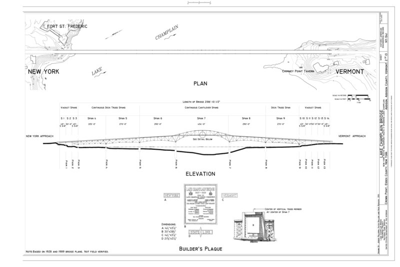
File:Plan, Elevation, Builder's Plaque - Lake Champlain Bridge, New York Route 185-Vermont Route 17 spanning Lake Champlain, Crown Point, Essex County, NY HAER NY-541 (sheet 2 of 13).tif

From Wikimedia Commons, the free media repository
Jump to navigation Jump to search

Original file(14,400 × 9,600 pixels, file size: 988 KB, MIME type: image/tiff)

Captions

Captions

Add a one-line explanation of what this file represents

Summary[edit]

Warning The original file is very high-resolution. It might not load properly or could cause your browser to freeze when opened at full size.
Plan, Elevation, Builder's Plaque - Lake Champlain Bridge, New York Route 185-Vermont Route 17 spanning Lake Champlain, Crown Point, Essex County, NY
Photographer
Pellerin, Jessie, creator
Title
Plan, Elevation, Builder's Plaque - Lake Champlain Bridge, New York Route 185-Vermont Route 17 spanning Lake Champlain, Crown Point, Essex County, NY
Depicted place New York; Essex County; Crown Point
Date 2011
Dimensions 24 x 36 in. (D size)
Current location
Library of Congress Prints and Photographs Division Washington, D.C. 20540 USA http://hdl.loc.gov/loc.pnp/pp.print
Accession number
HAER NY-541 (sheet 2 of 13)
Credit line
This file comes from the Historic American Buildings Survey (HABS), Historic American Engineering Record (HAER) or Historic American Landscapes Survey (HALS). These are programs of the National Park Service established for the purpose of documenting historic places. Records consist of measured drawings, archival photographs, and written reports.

This tag does not indicate the copyright status of the attached work. A normal copyright tag is still required. See Commons:Licensing.

Notes
  • Significance: The bridge was a nationally significant engineering landmark and one of the country's most technologically inventive and aesthetically sophisticated designs for highway bridges of the period. Opened to traffic in 1929, the bridge symbolized a convergence of four separate but related trends in transportation engineering, the origins of which can be traced to the closing decades of the nineteenth century: (1) the continuous truss technology; (2) a debate within the engineering community regarding the aesthetics of bridge design, and especially the aesthetics of truss bridges; (3) the use of cantilevers in truss design to extend span length, reduce construction costs, and address aesthetic concerns; and (4) evolving engineering responses to rapidly increasing travel by automobiles. Those trends intersected at Lake Champlain, and the inventive design that blossomed from that meeting is original in American engineering. Equally, important, the crossing served as the country's prototype for a succession of important bridges built or planned for major waterways during the remainder of the twentieth century.
  • Unprocessed Field note material exists for this structure: N1388
  • Survey number: HAER NY-541
  • Building/structure dates: 1928-1929 Initial Construction
  • Building/structure dates: 2009 Demolished
  • Building/structure dates: 1991 Subsequent Work
  • Building/structure dates: 1945 Subsequent Work
  • Building/structure dates: 1966 Subsequent Work
  • Building/structure dates: 1969 Subsequent Work
  • Building/structure dates: 1959 Subsequent Work
  • Building/structure dates: 1959 Subsequent Work
  • Building/structure dates: 1987 Subsequent Work
  • Building/structure dates: 1970 Subsequent Work
  • Building/structure dates: 1972-1974 Subsequent Work
  • Building/structure dates: 1980 Subsequent Work
  • Building/structure dates: 1983 Subsequent Work
  • Building/structure dates: 1995-1996 Subsequent Work
References

Related names:

Fay, Spofford and Thorndike; Merritt-Chapman and Scott Corporation; American Bridge Company; Scott Brothers Construction Company; Bennett, Alvin E; Malone, Charles; Lake Champlain Bridge Commission; New York State Department of Transportation; Farwell, Carroll; Jackson, D; Heney, L C; Champlain Valley Construction Company; Barker, Elmer Eugene; Peterson, Carl F; Finch, Roy G; Fay, Frederic H; Spofford, Charles M; Thorndike, Sturgis H; Wadsworth, J E; Troelsch, H W; Gemberling, J B; Norton, Fred; Van Brakle, Donald; Foote, Wallace C; Carroll, Joseph T; Pepper, John; Clark, Robert; Hanby, Gregory; Downs, Jerome; Lee, Warren; Flatiron Construction Company; LoRosso, Mark S, project manager; Reith, Christina, project manager; New York State Department of Transportation, consultant; Pellerin, Jessie, field team; Marston, Christopher, transmitter; Christianson, Justine, transmitter
Source https://www.loc.gov/pictures/item/ny2348.sheet.00002a
Permission
(Reusing this file)
Public domain This image or media file contains material based on a work of a National Park Service employee, created as part of that person's official duties. As a work of the U.S. federal government, such work is in the public domain in the United States. See the NPS website and NPS copyright policy for more information.
Other versions
Object location43° 57′ 01.01″ N, 73° 26′ 15″ W Kartographer map based on OpenStreetMap.View this and other nearby images on: OpenStreetMapinfo

File history

Click on a date/time to view the file as it appeared at that time.

Date/TimeThumbnailDimensionsUserComment
current09:33, 30 July 2014Thumbnail for version as of 09:33, 30 July 201414,400 × 9,600 (988 KB) (talk | contribs)GWToolset: Creating mediafile for Fæ. HABS 30 July 2014 (2601:2900)

Metadata