File:Plan La Rochelle et environs, 1773, Nicolas Chalmandrier, BNF Gallica.jpg

Archivo original (8564 × 6128 píxeles; tamaño de archivo: 43,38 MB; tipo MIME: image/jpeg)
Leyendas
Leyendas
| Atención | El archivo original tiene un número considerable de píxeles; si se abre en su resolución original, es posible que no se cargue correctamente o que provoque un bloqueo en el funcionamiento del navegador. Para evitar estos problemas puede utilizarse ZoomViewer. |
|---|
Resumen[editar]
| Descripción |
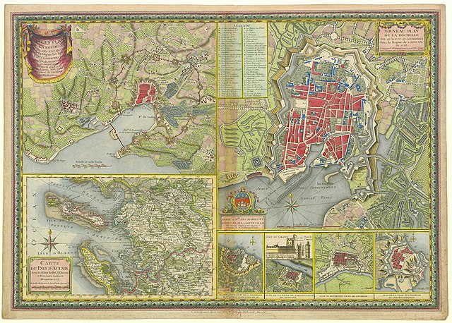
Français : Plan de La Rochelle et de ses environs lors du siège de 1627-1628, carte de l'Aunis et de La Rochelle en 1773, vue de certaines fortifications de villes de l'Aunis. English: Map of the city of La Rochelle and surroundings during the Siege in 1627-28, and in 1773, Map of the Aunis province, and views of some fortifications of cities of Aunis. |
||||
| Fecha | 1773. 2013-06-16 for upload | ||||
| Fuente |
Bibliothèque nationale de France |
||||
| Creador |
Nicolas Chalmandrier. Upload, stitch and restoration by Jebulon |
||||
| Permiso (Reutilización de este archivo) |
|
||||
| Georeferencing | If inappropriate please set warp_status = skip to hide. |
| Posición de la cámara | | Ubicación de esta y otras imágenes en: OpenStreetMap |
|---|
| Esta es una imagen retocada, lo que significa que ha sido alterada digitalmente de su versión original. Modificaciones: Cleaning of spots, dust, dirt, tears and scratches du to age. Correction of levels (light, saturation, contrast). With GIMP.
|
|

|
Esta imagen ha sido evaluada según los criterios de imágenes valiosas y es considerada la imagen más preciada en Wikimedia Commons en el ámbito de aplicación: Historical maps of La Rochelle, 1773 engraving. Para mayor información, puede ver su nominación en está página (en inglés): Commons:Valued image candidates/Plan La Rochelle et environs, 1773, Nicolas Chalmandrier, BNF Gallica.jpg. |
Licencia[editar]
|
Esta es una reproducción fotográfica fiel de una obra de arte bidimensional de dominio público. La obra de arte misma se halla en el dominio público por el motivo siguiente:
La postura oficial de la Fundación Wikimedia considera que «las reproducciones fieles de obras de arte bidimensionales de dominio público forman parte del dominio público».
Esta reproducción fotográfica, por ende, también se considera de dominio público dentro de los Estados Unidos. Es posible que otras jurisdicciones restrinjan la reutilización de este contenido; consúltese Reutilización de fotografías PD-Art (en inglés) para más detalles. | ||||
Historial del archivo
Haz clic sobre una fecha y hora para ver el archivo tal como apareció en ese momento.
| Fecha y hora | Miniatura | Dimensiones | Usuario | Comentario | |
|---|---|---|---|---|---|
| actual | 17:51 16 jun 2013 | | 8564 × 6128 (43,38 MB) | Jebulon (discusión | contribs.) | restored |
| 17:13 16 jun 2013 |  | 8564 × 6128 (34,89 MB) | Jebulon (discusión | contribs.) | User created page with UploadWizard |
No puedes sobrescribir este archivo.
Usos del archivo
Las siguientes páginas usan este archivo:
- User:Husky/POTY 2013 gallery
- User:Jebulon/Images de valeur
- User:Jebulon/Images remarquables
- User:Miya/sandbox/FP/2013/Galleries/Table
- User:Ö/Best/2013
- Commons:Featured picture candidates/File:Plan La Rochelle et environs, 1773, Nicolas Chalmandrier, BNF Gallica.jpg
- Commons:Featured picture candidates/Log/June 2013
- Commons:Featured pictures/Non-photographic media/Maps
- Commons:Featured pictures/chronological/2013-A
- Commons:Picture of the Year/2013/Candidates
- Commons:Picture of the Year/2013/Galleries/Table
- Commons:Picture of the Year/2013/R1/Gallery/2013-A
- Commons:Picture of the Year/2013/R1/Gallery/ALL
- Commons:Picture of the Year/2013/R1/Gallery/M06
- Commons:Picture of the Year/2013/R1/Gallery/Maps
- Commons:Picture of the Year/2013/R1/Results/Candidates
- Commons:Picture of the Year/2013/R1/v/Plan La Rochelle et environs, 1773, Nicolas Chalmandrier, BNF Gallica.jpg
- Commons:Valued image candidates/Plan La Rochelle et environs, 1773, Nicolas Chalmandrier, BNF Gallica.jpg
- Commons:Valued images by topic/Historical/Documents
Uso global del archivo
Las wikis siguientes utilizan este archivo:
- Uso en es.wikipedia.org
- Uso en fa.wikipedia.org
- Uso en fr.wikipedia.org
- Uso en mg.wikipedia.org
- Uso en nl.wikipedia.org
- Uso en uk.wikipedia.org
- Uso en vi.wikipedia.org
- Uso en www.wikidata.org
- Old maps of provinces of France
- Old maps of Île de Ré
- Maps of Île d'Oléron
- Île d'Aix
- Île Madame
- Historical images of La Rochelle
- Maps of La Rochelle
- 1773 in France
- 1627 in France
- Siege of La Rochelle (1627–1628)
- 1773 engravings
- Maps of Saint-Martin-de-Ré city walls and citadel
- Maps of Brouage city walls
- Old maps of Brouage
- Maps of Rochefort (Charente-Maritime)
- Citadelle du Château-d'Oléron
- Coats of arms of La Rochelle
- Maps of Aunis
- Old maps in the Bibliothèque nationale de France
- Nicolas Chalmandrier
- Old maps of Saint-Martin-de-Ré
- Old view of Vieux-Port de La Rochelle