File:Plan du rez de chaussée, du corps de logis double, de l'intendance de la Nlle Orléans, pour estre construit en maçonnerie de briques, entre cour et jardin-juin 1749. LOC 2011593380.jpg
Jump to navigation
Jump to search
Size of this preview: 800 × 585 pixels. Other resolutions: 320 × 234 pixels | 640 × 468 pixels | 1,024 × 748 pixels | 1,280 × 935 pixels | 2,560 × 1,871 pixels | 3,900 × 2,850 pixels.
Original file (3,900 × 2,850 pixels, file size: 1.32 MB, MIME type: image/jpeg)
Captions
Captions
Add a one-line explanation of what this file represents
Summary
[edit]| Description |
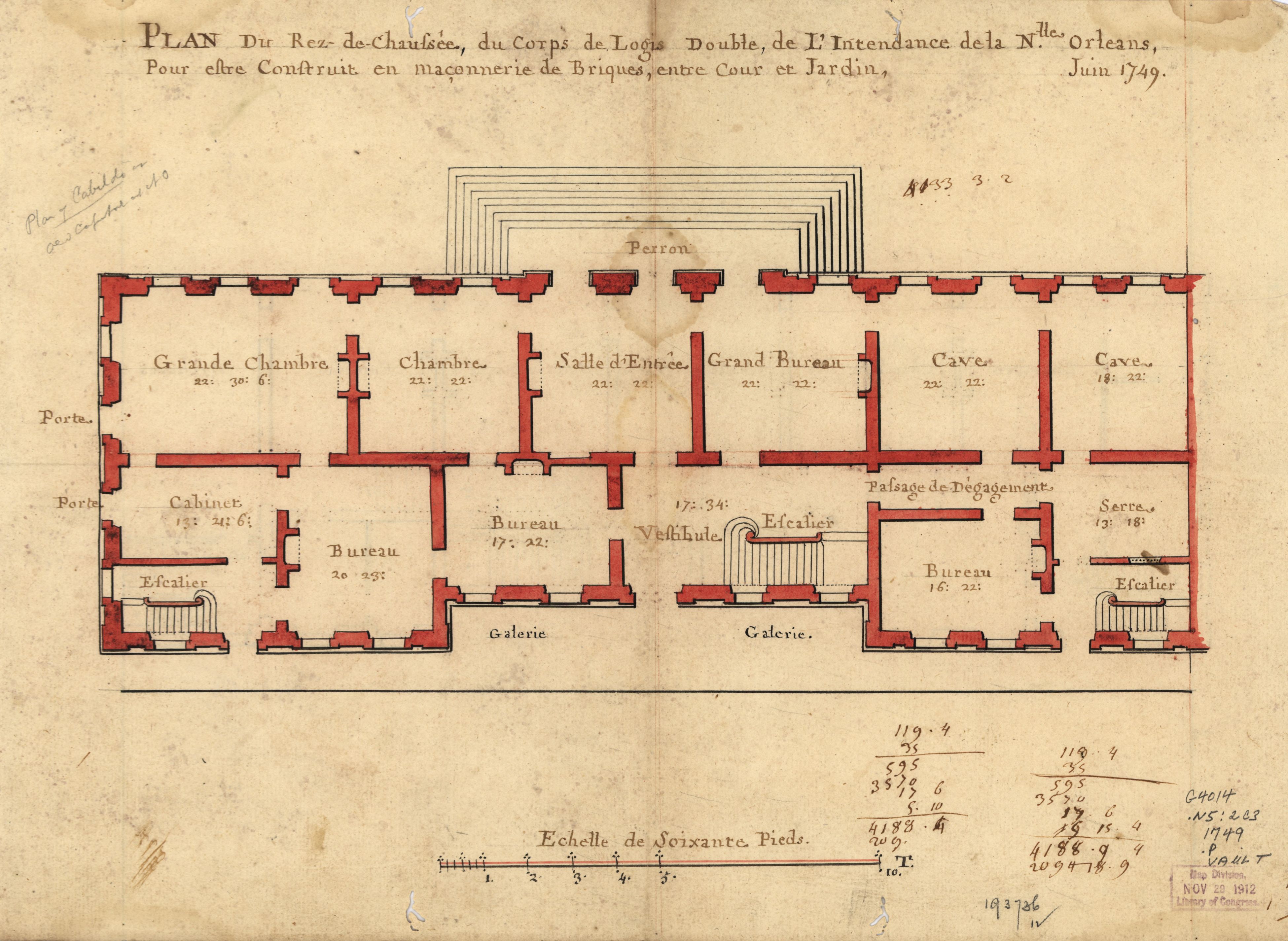
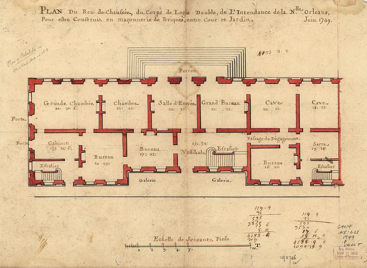
English: Plan of other floor and number annotations on verso. Includes pencil notes in upper margin "Plan of Cabildo" and in lower margin "CT000694" and number annotations. Available also through the Library of Congress Web site as a raster image. |
||
| Title | Plan du rez de chaussée, du corps de logis double, de l'intendance de la Nlle Orléans, pour estre construit en maçonnerie de briques, entre cour et jardin--juin 1749. | ||
| Shelf ID | G4014.N5:2C3 1749 .P5 | ||
| Date | |||
| Source | https://www.loc.gov/item/2011593380/ | ||
| Author | Unknown author | ||
| Permission (Reusing this file) |
|
||
| Other versions |
|
||
| Location | The Cabildo · United States · Lousiana · New Orleans · Cabildo, The (New Orleans) · Louisiana | ||
| Part of | American Memory · Cities And Towns · Catalog · Geography And Map Division | ||
| Subject | Buildings, Structures, Etc · Cabildo, The (New Orleans, La.) · New Orleans (La.) · Charts, Diagrams, Etc · United States · Maps · Designs And Plans · New Orleans · Cabildo, The (New Orleans) · Louisiana · Manuscript Maps |

Licensing
[edit]
|
This is a faithful photographic reproduction of a two-dimensional, public domain work of art. The work of art itself is in the public domain for the following reason:
The official position taken by the Wikimedia Foundation is that "faithful reproductions of two-dimensional public domain works of art are public domain".
This photographic reproduction is therefore also considered to be in the public domain in the United States. In other jurisdictions, re-use of this content may be restricted; see Reuse of PD-Art photographs for details. | ||||
File history
Click on a date/time to view the file as it appeared at that time.
| Date/Time | Thumbnail | Dimensions | User | Comment | |
|---|---|---|---|---|---|
| current | 21:44, 14 May 2018 | | 3,900 × 2,850 (1.32 MB) | Fæ (talk | contribs) | LOC Maps https://www.loc.gov/item/2011593380/ #8624 |
You cannot overwrite this file.
File usage on Commons
The following page uses this file:
File usage on other wikis
The following other wikis use this file:
- Usage on es.wikipedia.org