File:Plano que manifiesta del modo que csta formada la Ysla Santa Cathalina en la costa del Brasil situada su mediama en los 27 gos. y 72 ms. de latitud y en 327 gs. y 10 ms., merional de Tenerife. LOC 89696478.tif
Jump to navigation
Jump to search

Size of this JPG preview of this TIF file: 800 × 569 pixels. Other resolutions: 320 × 228 pixels | 640 × 455 pixels | 1,024 × 728 pixels | 1,280 × 910 pixels | 2,560 × 1,820 pixels | 4,994 × 3,551 pixels.
Original file (4,994 × 3,551 pixels, file size: 50.74 MB, MIME type: image/tiff)
Captions
Captions
Add a one-line explanation of what this file represents
Summary
[edit]| Description |
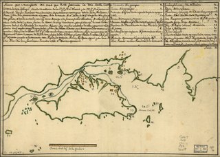
English: Depths shown by soundings. Oriented with north to the right. Prime meridian: Tenerife. Watermarks: Two decorative shields and indecipherable lettering. Pen-and-ink and watercolor. Mounted on cloth backing. LC Luso-Hispanic World, 182 Maggs number annotated in pencil in lower right corner: 293. Includes note and index. Available also through the Library of Congress Web site as a raster image. Vault |
||
| Title | Plano que manifiesta del modo que csta formada la Ysla Santa Cathalina en la costa del Brasil situada su mediama en los 27 gos. y 72 ms. de latitud y en 327 gs. y 10 ms., merional de Tenerife. | ||
| Shelf ID | G5617.S23 17-- .P52 | ||
| Date | |||
| Source | https://www.loc.gov/item/89696478/ | ||
| Author | Unknown author | ||
| Permission (Reusing this file) |
|
||
| Other versions |
|
||
| Location | Atlantic Coast · Brazil · Santa Catarina · Santa Catarina (State) · Santa Catarina Island | ||
| Part of | American Memory · General Maps · Catalog · Geography And Map Division | ||
| Subject | Brazil · Maps, Manuscript · Coasts · Santa Catarina Island (Brazil) · Santa Catarina (State) · Maps · Early Works To 1800 · Atlantic Coast (Brazil) · Atlantic Coast · Santa Catarina Island |


Licensing
[edit]|
This is a faithful photographic reproduction of a two-dimensional, public domain work of art. The work of art itself is in the public domain for the following reason:
The official position taken by the Wikimedia Foundation is that "faithful reproductions of two-dimensional public domain works of art are public domain".
This photographic reproduction is therefore also considered to be in the public domain in the United States. In other jurisdictions, re-use of this content may be restricted; see Reuse of PD-Art photographs for details. | ||||
File history
Click on a date/time to view the file as it appeared at that time.
| Date/Time | Thumbnail | Dimensions | User | Comment | |
|---|---|---|---|---|---|
| current | 01:40, 17 July 2018 |  | 4,994 × 3,551 (50.74 MB) | Fæ (talk | contribs) | LOC Maps https://www.loc.gov/item/89696478/ #1779 |
You cannot overwrite this file.
File usage on Commons
The following page uses this file: