File:Plate 3-Bounded by (Dutch Kills Creek) Water Street, Borden Avenue, Orton Street, Thomson Avenue, Van Dam Street, Skillman Avenue (Sunnyside Yard), Laurel Hill Avenue, Foster Avenue, Heiser NYPL1516400.tiff
Jump to navigation
Jump to search
Size of this JPG preview of this TIF file: 799 × 600 pixels. Other resolutions: 320 × 240 pixels | 640 × 480 pixels | 1,023 × 768 pixels | 1,280 × 961 pixels | 2,560 × 1,922 pixels | 7,230 × 5,428 pixels.
Original file (7,230 × 5,428 pixels, file size: 112.28 MB, MIME type: image/tiff)
Captions
Captions
Add a one-line explanation of what this file represents
Summary[edit]
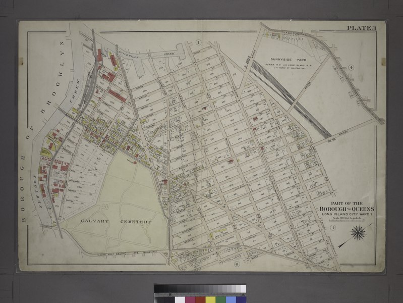
| Description | [Plate 3:Bounded by (Dutch Kills Creek) Water Street, Borden Avenue, Orton Street, Thomson Avenue, Van Dam Street, Skillman Avenue (Sunnyside Yard), Laurel Hill Avenue, Foster Avenue, Heiser Street, Bliss Street, Anabelle Avenue, Celtic Avenue and Review Avenue.]; Atlases of New York city. / Atlas of the city of New York, borough of Queens, Long Island City, Newtown, Flushing, Jamaica, Far Rockaway, from actual surveys and official plans / by George W. and Walter S. Bromley. | |||||||||||||||||||||||
| Catalogue call number | Map Div.+++ (Queens, New York) (Bromley, G.W., and Co. Atlas of the City of New York, Borough of Queens. 1909) | |||||||||||||||||||||||
| Item/Page/Plate | Plate 3 | |||||||||||||||||||||||
| Alternate title | Part of the Borough of Queens, Long Island City, Ward 1. | |||||||||||||||||||||||
| Date | ||||||||||||||||||||||||
| Source |
http://digitalgallery.nypl.org/nypldigital/dgkeysearchdetail.cfm?imageID=1516400
|
|||||||||||||||||||||||
| Author | G.W. Bromley and Co. -- Publisher | |||||||||||||||||||||||
| Permission (Reusing this file) |
From The Lionel Pincus and Princess Firyal Map Division. http://maps.nypl.org
|
|||||||||||||||||||||||
| Source description | 96] p. : 48 col. maps ; 57 cm. | |||||||||||||||||||||||
| Location | Stephen A. Schwarzman Building / The Lionel Pincus and Princess Firyal Map Division | |||||||||||||||||||||||
| Digital item published | 8-22-2006; updated 6-23-2011 | |||||||||||||||||||||||
| Digital ID | 1516400 | |||||||||||||||||||||||

The making of this file was supported by Wikimedia UK.
To see other files made with the support of Wikimedia UK, please see the category Supported by Wikimedia UK.
|
File history
Click on a date/time to view the file as it appeared at that time.
| Date/Time | Thumbnail | Dimensions | User | Comment | |
|---|---|---|---|---|---|
| current | 04:42, 4 May 2014 |  | 7,230 × 5,428 (112.28 MB) | Fæ (talk | contribs) | GWToolset:: Creating mediafile for Fæ. Tranche 3 11591-16518 @ 2 May, 06:47 BST |
You cannot overwrite this file.
File usage on Commons
There are no pages that use this file.