File:Poland location map.svg
Zur Navigation springen
Zur Suche springen

Gröössi vor PNG-Vorschou vor SVG-Datei: 617 × 600 Pixel. Wyteri Ufflösige: 247 × 240 Pixel | 494 × 480 Pixel | 790 × 768 Pixel | 1.053 × 1.024 Pixel | 2.107 × 2.048 Pixel | 861 × 837 Pixel.
Originaldatei (SVG-Datei, Basisgrößi: 861 × 837 Pixel, Dateigrößi: 213 KB)
Bildtexte
Kurzbeschreibungen
Ergänze eine einzeilige Erklärung, was diese Datei darstellt.
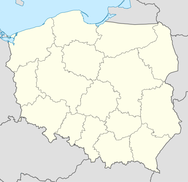
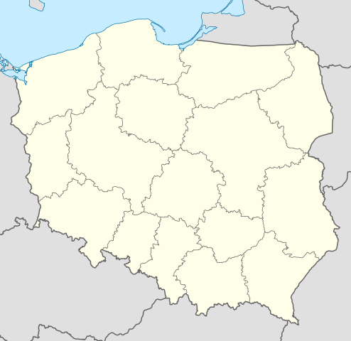
Poland location map
Bschryybig[ändere]
| Bschryybig |
Deutsch: Positionskarte von Polen
Quadratische Plattkarte, N-S-Streckung 160 %. Geographische Begrenzung der Karte:
English: Location map of Poland
Equirectangular projection, N/S stretching 160 %. Geographic limits of the map:
|
||
| Datum | |||
| Quälle |
Eigeni Arbet using
|
||
| Urheber | NordNordWest | ||
| Anderi Versione |
|
||
| SVG‑Erstellung | Diese W3C-invalide Landkarte wurde mit Adobe Illustrator erstellt.
|


Lizänzierig[ändere]
Ich haa s Urheberrächt an däm Wärch un vereffetlig s dodermit unter däne Lizänze:

|
Des Dokumänt derf kopiert, verbreitet un/oder bearbeitet wäre unter dr Bedingige vu dr GNU-Lizänz fir freji Dokumäntation, Version 1.2 oder ere spetere Version, vereffetligt dur Free Software Foundation. S het keini uuveränderlige Abschnitt, kei vordere Umschlagstext un kei hindere Umschlagstext. E Kopii vu dr Lizänz isch verfiegbar im Abschnitt GNU-Lizänz fir freji Dokumäntation. |
Die Datei isch lizänziert unter dr Creative-Commons-Lizenz Namensnännig – Wytergab unter glyche Bedingige 3.0 nit portiert.
- Du derfsch:
- des Wärch an anderi wytergee – des Wärch kopiere, verbreite un ibertrage
- des Wärch verändere – des Wärch aapasse
- Unter däne Bedingige:
- Namenännig – Du muesch aagmässeni Aagabe zum Urheber un dr Rächt mache, e Link zue dr Lizänz zuefiege un aagee, eb Änderige gmacht wore sin. Die Aagabe chenne in ere aagmässene Art gmacht wäre, aber nit eso, ass dr Yydruck entstoht, ass dr Lizänzgeber Dii oder Dyy Gebruch vum Wärch unterstitze un guetheiße.
- Wytergab unter glyche Bedingige – Wänn du des Wärch veränderesch, umwandlesch oder druf ufböusch, no derfsch s Ergebnis nume unter dr glyche oder ere kumpatible Lizänz wie s Orginal vereffetlige.
Du chasch sälber e Lizänz uuswehle.
Dateiversione
Klick uf e Zytpunkt zu aazeige, wie s dert usgsäh het.
| Version vom | Vorschaubild | Mäß | Benutzer | Kommentar | |
|---|---|---|---|---|---|
| aktuell | 12:34, 2. Okt. 2012 | | 861 × 837 (213 KB) | Palosirkka (Diskussion | Byträg) | Reverted to version as of 20:23, 23 November 2011 Location maps must remain very accurate |
| 20:37, 1. Okt. 2012 |  | 861 × 837 (196 KB) | Palosirkka (Diskussion | Byträg) | Scrubbed with http://codedread.com/scour/ | |
| 20:23, 23. Nov. 2011 |  | 861 × 837 (213 KB) | NordNordWest (Diskussion | Byträg) | upd | |
| 11:28, 8. Dez. 2008 |  | 862 × 838 (377 KB) | NordNordWest (Diskussion | Byträg) | Reverted to version as of 09:25, 8 July 2008, an often used image shouldn't be changed without discussion | |
| 09:26, 8. Dez. 2008 |  | 862 × 838 (378 KB) | Mareklug (Diskussion | Byträg) | I made the featured background (territory of Poland) pure white for better contrast. | |
| 09:25, 8. Jul. 2008 |  | 862 × 838 (377 KB) | NordNordWest (Diskussion | Byträg) | {{Information |Description= {{de|Positionskarte von Polen}} Quadratische Plattkarte, N-S-Streckung 160 %. Geographische Begrenzung der Karte: * N: 55.2° N * S: 48.7° N * W: 13.8° O * O: 24.5° O {{en|Location map of Poland} |
Du chasch die Datei nit iberschryybe.
Verwändig vu dr Datei
Die 36 Syte bruuche die Datei:
- User:NordNordWest/Gallery/Location maps
- User:SpinnerLaserz/Flags/Flags of Bashkortostan/Poland
- User:SpinnerLaserz/Flags/Flags of France/Poland
- User:SpinnerLaserz/Flags/Flags of Germany/Poland
- User:SpinnerLaserz/Flags/Flags of Poland/Poland
- User:SpinnerLaserz/Flags/Flags of Sweden/Poland
- User:SpinnerLaserz/Flags/Flags of the Czech Republic/Poland
- User:SpinnerLaserz/Flags/Flags of the Netherlands/Poland
- User:SpinnerLaserz/Flags/Flags of the United Kingdom/Poland
- User:SpinnerLaserzthe2nd/Flags/Flags of Hungary/Poland
- File:Distribution of Marmota marmota latirostris.svg
- File:Dolnoslaskie in Poland.svg
- File:Fagus sylvatica - Distribution in Poland.svg
- File:Kujawsko-Pomorskie in Poland.svg
- File:Lubelskie in Poland.svg
- File:Lubuskie in Poland.svg
- File:Lódzkie in Poland.svg
- File:Malopolskie in Poland.svg
- File:Map of Poland new ISO-3166-2 PL (2018).svg
- File:Mazowieckie in Poland.svg
- File:Opolskie in Poland.svg
- File:Podkarpackie in Poland.svg
- File:Podlaskie in Poland.svg
- File:Poland2 location map.svg
- File:Poland location map.svg
- File:Poland location map white.svg
- File:Pomorskie in Poland.svg
- File:Relief Map of Poland.png
- File:Relief Map of Poland.svg
- File:Religion in Poland.png
- File:Republika-Tarnobrzeska.png
- File:Slaskie in Poland.svg
- File:Swietokrzyskie in Poland.svg
- File:Warminsko-Mazurskie in Poland.svg
- File:Wielkopolskie in Poland.svg
- File:Zachodniopomorskie in Poland.svg
.svg)
Wältwyti Dateinutzig
Die andere Wikis bruche die Datei:
- Gebruch uf ar.wikipedia.org
- Gebruch uf av.wikipedia.org
- Gebruch uf bn.wikipedia.org
- Gebruch uf bs.wikipedia.org
- Gebruch uf ceb.wikipedia.org
- Gebruch uf ckb.wikipedia.org
- Gebruch uf de.wikipedia.org
- Gebruch uf diq.wikipedia.org
- Gebruch uf el.wikipedia.org
- Gebruch uf en.wikipedia.org
- Gebruch uf en.wikivoyage.org
- Gebruch uf en.wiktionary.org
- Gebruch uf eo.wikipedia.org
- Gebruch uf eo.wikivoyage.org
- Gebruch uf es.wikipedia.org
- Gebruch uf fa.wikipedia.org
- Gebruch uf fo.wikipedia.org
- Gebruch uf fr.wikipedia.org
- Gebruch uf hr.wikipedia.org
- Gebruch uf hsb.wikipedia.org
- Gebruch uf hu.wikipedia.org
Wältwyti Verwändig vu däre Datei aaluege.