File:Provinces of Cambodia loss to Thailand during Franco-Thai War.png

Fitxer original (1.200 × 900 píxels, mida del fitxer: 187 Ko, tipus MIME: image/png)
Llegendes
Llegendes
This file may not have the correct information on its copyright status.
The reason given by the user who added this tag is: File has incomplete source information; it's obviously based on other CC-licensed maps here on Commons.
Notify the uploader with:
Items tagged with this template are sorted into Category:Items with disputed copyright information.
|
Resum
[modifica]
| Descripció |
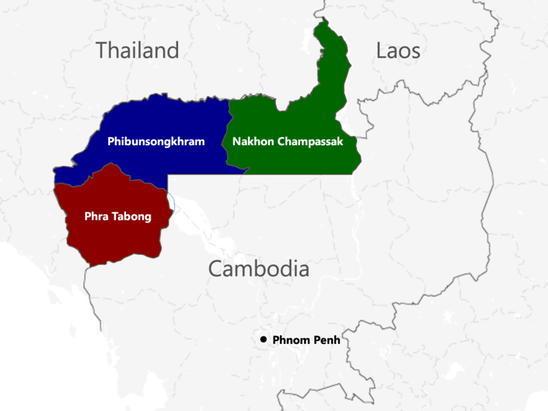
English: The territories of Cambodia and Laos annexed by Thailand in 1941, according to "ประกาศ ใช้อนุสัญญาสันติภาพและบรรดาภาคผนวก ระหว่างไทยและฝรั่งเศส", regrouped as in the map. |
| Data | |
| Font | Treball propi |
| Autor | Murashel, edited by: Thanyakij |
Llicència
[modifica]
- Sou lliure de:
- compartir – copiar, distribuir i comunicar públicament l'obra
- adaptar – fer-ne obres derivades
- Amb les condicions següents:
- reconeixement – Heu de donar la informació adequada sobre l'autor, proporcionar un enllaç a la llicència i indicar si s'han realitzat canvis. Podeu fer-ho amb qualsevol mitjà raonable, però de cap manera no suggereixi que l'autor us dóna suport o aprova l'ús que en feu.
- compartir igual – Si modifiqueu, transformeu, o generareu amb el material, haureu de distribuir les vostres contribucions sota una llicència similar o una de compatible com l'original
Historial del fitxer
Cliqueu una data/hora per veure el fitxer tal com era aleshores.
| Data/hora | Miniatura | Dimensions | Usuari/a | Comentari | |
|---|---|---|---|---|---|
| actual | 04:48, 23 jul 2017 | | 1.200 × 900 (187 Ko) | Aquapatinth (discussió | contribucions) | change - southern border of Phibulsongkhram and Nakhon Champassak Provinces to the 13.5th parallel and - southeastern border of Phibulsongkhram to meridian line from the point which border line between Siem Reap and Battanbang Province met Tonle Sap.... |
| 07:19, 16 feb 2016 |  | 1.001 × 921 (303 Ko) | Xufanc (discussió | contribucions) | corrected spelling | |
| 05:49, 12 feb 2016 |  | 1.001 × 921 (303 Ko) | Xufanc (discussió | contribucions) | Added missing part of Nakhon Champassak Province | |
| 17:46, 25 set 2014 |  | 1.000 × 903 (308 Ko) | RJFF (discussió | contribucions) | Somehow the revert did not work. | |
| 17:38, 25 set 2014 |  | 1.000 × 903 (308 Ko) | RJFF (discussió | contribucions) | Reverted to version as of 17:36, 25 September 2014 | |
| 17:37, 25 set 2014 |  | 1.000 × 903 (308 Ko) | RJFF (discussió | contribucions) | Reverted to version as of 18:43, 30 December 2013 | |
| 17:36, 25 set 2014 |  | 1.000 × 903 (308 Ko) | RJFF (discussió | contribucions) | Reverted to version as of 18:43, 30 December 2013: The other version seems to be more accurate, see [http://daravireak.files.wordpress.com/2012/10/map_thailand_3province_indochine.png here], [http://www.websitesrcg.com/border/maps/indochina-1942.jpg he... | |
| 15:32, 9 feb 2014 |  | 1.000 × 903 (321 Ko) | Murashel (discussió | contribucions) | In Peace treaty in Tokyo Thais gain territory of Koh Kong. | |
| 18:43, 30 des 2013 |  | 1.000 × 903 (308 Ko) | Derkommander0916 (discussió | contribucions) | Thailand never took Koh Kong and Pursat Refer this: http://www.geographicus.com/P/AntiqueMap/Thailand-japanese-1943 | |
| 15:01, 9 juny 2013 |  | 1.000 × 903 (321 Ko) | Murashel (discussió | contribucions) | User created page with UploadWizard |
No podeu sobreescriure aquest fitxer.
Ús del fitxer
No hi ha pàgines que utilitzin aquest fitxer.
Ús global del fitxer
Utilització d'aquest fitxer en altres wikis:
- Utilització a ca.wikipedia.org
- Utilització a en.wikipedia.org
- Utilització a es.wikipedia.org
- Utilització a fa.wikipedia.org
- Utilització a fr.wikipedia.org
- Utilització a he.wikipedia.org
- Utilització a it.wikipedia.org
- Utilització a ja.wikipedia.org
- Utilització a km.wikipedia.org
- Utilització a lo.wikipedia.org
- Utilització a nl.wikipedia.org
- Utilització a pl.wikipedia.org
- Utilització a ru.wikipedia.org
- Utilització a th.wikipedia.org
- Utilització a vi.wikipedia.org
- Utilització a zh.wikipedia.org