File:Queens, Vol. 1, Double Page Plate No. 16; Part of Ward 4; Jamaica; (Map bounded by Jericho Turnpike, Hempstead and Jamaica Plank Road, First Ave., Queens Boulevard, 2nd Ave., 3rd Ave., 4th NYPL1693859.tiff
Jump to navigation
Jump to search

Size of this JPG preview of this TIF file: 800 × 593 pixels. Other resolutions: 320 × 237 pixels | 640 × 474 pixels | 1,024 × 759 pixels | 1,280 × 948 pixels | 2,560 × 1,897 pixels | 6,888 × 5,104 pixels.
Original file (6,888 × 5,104 pixels, file size: 100.59 MB, MIME type: image/tiff)
Captions
Captions
Add a one-line explanation of what this file represents
Summary[edit]
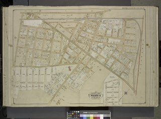
| Description | Queens, Vol. 1, Double Page Plate No. 16; Part of Ward 4; Jamaica; [Map bounded by Jericho Turnpike, Hempstead and Jamaica Plank Road, First Ave., Queens Boulevard, 2nd Ave., 3rd Ave., 4th Ave., 5th Ave., Sherwood Ave., 6th Ave., Franklin Ave., Clinton Ave., Springfield Road, Creed Ave., Wertlans Ave., Albany Ave., Crystal Ave., Delevan Ave., Euclid Ave., Fillmore Ave., Hudson Ave., Linden Ave., Queens Parkway, Preston Ave., Dewey Ave., Grant Ave., Hollis Ave., Lynn Ave., Catharine Ave., Madison Ave., Findlay Ave., Ostend Ave.; Including Bennett St., West Whittier St., Hugo St., Seymour St., Amos St., Hanover St., Bergen St., Joseph St., N. Wertland St., Carey St., Irving St., Sigourney St., Sengwick St., Chestnut St., Oak St., Elm St., Stewart St., Paulding St., Mead St., Lawrence St., Clement St., Milton St., Kirtland St.; Including Stewart PL., Ascot PL., Belmont PL., Creed PL., Williams PL., Crescent PL., Haven PL.]; Sub Plan; [Map bounded by Old Country Road, Livonia Ave., Norwood Ave., Queens Parkway, Stanley Ave., Webster Ave., Linden Ave.]; Atlases of New York city. / Atlas of the borough of Queens, city of New York : based upon official plans and maps on file in the various city offices; supplemented by careful field measurements and personal observations / by and under the supervision of Hugo Ullitz. / Fourth and fifth wards: Jamaica and Rockaway. | |||||||||||||||||||||||
| Catalogue call number | Map Div.+++ (Queens, New York. 1912-1913) (Hyde, E.B., Map Co., Inc. Atlas of the borough of Queens) | |||||||||||||||||||||||
| Item/Page/Plate | 16 | |||||||||||||||||||||||
| Date | between 1907 and 1908 | |||||||||||||||||||||||
| Source |
http://digitalgallery.nypl.org/nypldigital/dgkeysearchdetail.cfm?imageID=1693859
|
|||||||||||||||||||||||
| Author | ||||||||||||||||||||||||
| Permission (Reusing this file) |
From The Lionel Pincus and Princess Firyal Map Division. http://maps.nypl.org
|
|||||||||||||||||||||||
| Location | Stephen A. Schwarzman Building / The Lionel Pincus and Princess Firyal Map Division | |||||||||||||||||||||||
| Digital item published | 2-27-2009; updated 3-25-2011 | |||||||||||||||||||||||
| Digital ID | 1693859 | |||||||||||||||||||||||

The making of this file was supported by Wikimedia UK.
To see other files made with the support of Wikimedia UK, please see the category Supported by Wikimedia UK.
|
File history
Click on a date/time to view the file as it appeared at that time.
| Date/Time | Thumbnail | Dimensions | User | Comment | |
|---|---|---|---|---|---|
| current | 15:53, 8 May 2014 |  | 6,888 × 5,104 (100.59 MB) | Fæ (talk | contribs) | GWToolset: Creating mediafile for Fæ. Tranche 4 -4989 restart @08:55 BST, 7 May 2014 |
You cannot overwrite this file.
File usage on Commons
There are no pages that use this file.