File:Queues on the A338 out of Bournemouth - geograph.org.uk - 1331307.jpg

Original file (480 × 640 pixels, file size: 67 KB, MIME type: image/jpeg)
Captions
Captions
Summary[edit]
| Description |
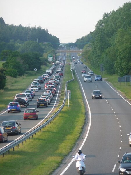
English: A simple equation. Half term + weekend + glorious sunshine + beach resort
= daytrippers + weekenders + weeklong holidaymakers = tailbacks heading out of town on Sunday evening I had driven back home from London, coming past here at about 6 o'clock this Sunday evening at the end of the half-term holiday. The tailbacks for Ashley Heath roundabout (in SU1304) stretched down the A338 to the outskirts of Bournemouth, here, and for a mile or so back towards town (see 1331305). The situation was the same now, an hour-and-a-bit later. In fact, the whole eight- or nine-mile line was not often properly stationary, but was travelling at little more than walking pace. Those who are heading all the way to Ashley, which I'm sure was the plan for the majority, will likely have longer than an hour in which to appreciate the newly resurfaced northbound carriageway here. Of course, being stuck in such a traffic jam is very unfunny. Nevertheless, us locals cannot help a sort of sympathetic chuckle as we drive in the opposite direction, both leaving town in the morning when everyone is coming in, or vice versa in the evening. Still, they have had a super day on the beach, parking their car in direct sunlight for about £12, giving their newly sunburnt flesh a chance to experience very hot upholstery before embarking on a wearisome journey home. |
| Date | |
| Source | From geograph.org.uk |
| Author | Chris Downer |
| Attribution (required by the license) | Chris Downer / A simple equation / |
| Camera location | | View this and other nearby images on: OpenStreetMap |
|---|
_heading:22.00&language=en)
| Object location | | View this and other nearby images on: OpenStreetMap |
|---|
_heading:22.00&language=en)
Licensing[edit]

|
This image was taken from the Geograph project collection. See this photograph's page on the Geograph website for the photographer's contact details. The copyright on this image is owned by Chris Downer and is licensed for reuse under the Creative Commons Attribution-ShareAlike 2.0 license.
|
- You are free:
- to share – to copy, distribute and transmit the work
- to remix – to adapt the work
- Under the following conditions:
- attribution – You must give appropriate credit, provide a link to the license, and indicate if changes were made. You may do so in any reasonable manner, but not in any way that suggests the licensor endorses you or your use.
- share alike – If you remix, transform, or build upon the material, you must distribute your contributions under the same or compatible license as the original.
File history
Click on a date/time to view the file as it appeared at that time.
| Date/Time | Thumbnail | Dimensions | User | Comment | |
|---|---|---|---|---|---|
| current | 00:26, 28 February 2011 | | 480 × 640 (67 KB) | GeographBot (talk | contribs) | == {{int:filedesc}} == {{Information |description={{en|1=A simple equation Half term + weekend + glorious sunshine + beach resort = daytrippers + weekenders + weeklong holidaymakers = tailbacks heading out of town on Sunday evening I had driven back |
You cannot overwrite this file.
File usage on Commons
The following page uses this file:
- File:A simple equation - geograph.org.uk - 1331307.jpg (file redirect)