File:Railway trackbed near Shipton Lee - geograph.org.uk - 379579.jpg
Jump to navigation
Jump to search
No higher resolution available.
Railway_trackbed_near_Shipton_Lee_-_geograph.org.uk_-_379579.jpg (640 × 480 pixels, file size: 161 KB, MIME type: image/jpeg)
Captions
Captions
Add a one-line explanation of what this file represents
Summary
[edit]
| Description |
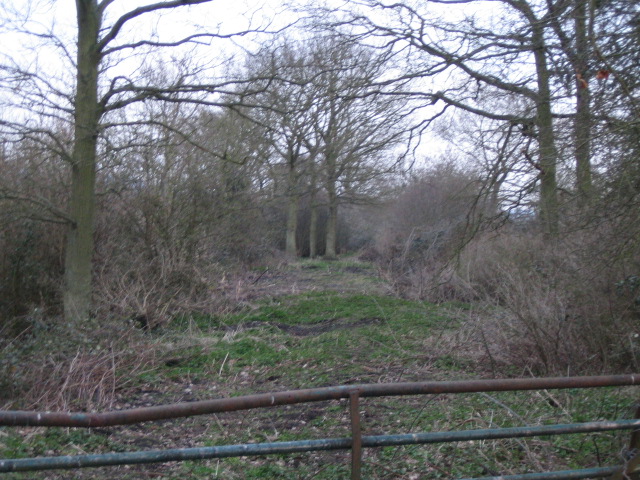
English: Railway trackbed near Shipton Lee This is the trackbed of the Aylesbury & Buckingham Railway which opened on 23 September 1968. The line ran from Aylesbury to Verney Junction with intermediate stations at Waddesdon, Quainton Road, Grandborough Road and Winslow Road, though it was never extended to Buckingham. The Aylesbury to Quainton Road section was part of the Great Central Railway. The line was initially worked by the GWR with three services in each direction daily. The Metropolitan Railway took over in 1894, and ran services between Verney Junction and Baker Street with regular through services for many years. In 1933 it became part of the Metropolitan Line of London Transport. As London Transport did not want to run suburban services deep into the heart of Buckinghamshire, it decided to close the line west of Aylesbury. Passenger services were ended on 4 July 1936, see http://www.20thcenturylondon.org.uk/server.php?show=conObject.1947, and the line was made single track. A last parcels train ran from Verney Junction on 6 September 1947, and the line was eventually closed and lifted in 1956.
Here, looking south, the railway ran on an embankment through farmland, and slowly curved right to a crossing where Railway Cottage is today, 934094, and then on to Quainton Road station 1.5km away. Considering the rails were lifted 50 years ago it is surprising that the trackbed is not more overgrown. |
| Date | |
| Source | From geograph.org.uk |
| Author | Andy Gryce |
| Attribution (required by the license) | Andy Gryce / Railway trackbed near Shipton Lee / |
| Camera location | | View this and other nearby images on: OpenStreetMap |
|---|
_heading:180.00&language=en)
| Object location | | View this and other nearby images on: OpenStreetMap |
|---|
_heading:180.00&language=en)
Licensing
[edit]

|
This image was taken from the Geograph project collection. See this photograph's page on the Geograph website for the photographer's contact details. The copyright on this image is owned by Andy Gryce and is licensed for reuse under the Creative Commons Attribution-ShareAlike 2.0 license.
|
This file is licensed under the Creative Commons Attribution-Share Alike 2.0 Generic license.
Attribution: Andy Gryce
- You are free:
- to share – to copy, distribute and transmit the work
- to remix – to adapt the work
- Under the following conditions:
- attribution – You must give appropriate credit, provide a link to the license, and indicate if changes were made. You may do so in any reasonable manner, but not in any way that suggests the licensor endorses you or your use.
- share alike – If you remix, transform, or build upon the material, you must distribute your contributions under the same or compatible license as the original.
File history
Click on a date/time to view the file as it appeared at that time.
| Date/Time | Thumbnail | Dimensions | User | Comment | |
|---|---|---|---|---|---|
| current | 21:17, 4 January 2011 | | 640 × 480 (161 KB) | GeographBot (talk | contribs) | == {{int:filedesc}} == {{Information |description={{en|1=Railway trackbed near Shipton Lee This is the trackbed of the Aylesbury & Buckingham Railway which opened on 23 September 1968. The line ran from Aylesbury to Verney Junction with intermediate stati |
You cannot overwrite this file.
File usage on Commons
There are no pages that use this file.