File:Reichskommissariat Ostland Administrative.png
跳转到导航
跳转到搜索

本预览的尺寸:415 × 599像素。 其他分辨率:166 × 240像素 | 333 × 480像素 | 532 × 768像素 | 710 × 1,024像素 | 1,420 × 2,048像素 | 2,856 × 4,120像素。
原始文件 (2,856 × 4,120像素,文件大小:1.89 MB,MIME类型:image/png)
说明
说明
添加一行文字以描述该文件所表现的内容
摘要[编辑]
| 描述 |
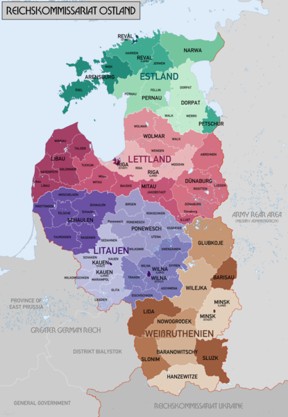
English: Administrative Map of Reichskommissariat Ostland |
| 日期 | |
| 来源 | 自己的作品 |
| 作者 | XrysD |
| 其他版本 |
此文件衍生的作品: Gen Okrug Belarus Administrative.png 此文件衍生的作品: Generalbezirk Lettland.png |
许可协议[编辑]
我,本作品著作权人,特此采用以下许可协议发表本作品:

|
已授权您依据自由软件基金会发行的无固定段落及封面封底文字(Invariant Sections, Front-Cover Texts, and Back-Cover Texts)的GNU自由文件许可协议1.2版或任意后续版本的条款,复制、传播和/或修改本文件。该协议的副本请见“GNU Free Documentation License”。 |
| 本文件采用知识共享署名-相同方式共享 3.0 未本地化版本许可协议授权。 | ||
| ||
| 本许可协议标签作为GFDL许可协议更新的组成部分被添加至本文件。 |
| 非营利著作权:本艺术作品是自由的,您可以依据自由艺术作品许可协议的条款传播和/或修改本艺术作品。您可以在Copyleft Attitude网站或其他网站找到该许可协议的样本。 |
您可以选择您需要的许可协议。
文件历史
点击某个日期/时间查看对应时刻的文件。
| 日期/时间 | 缩略图 | 大小 | 用户 | 备注 | |
|---|---|---|---|---|---|
| 当前 | 2018年2月20日 (二) 20:46 | | 2,856 × 4,120(1.89 MB) | XrysD(留言 | 贡献) | Changed map colours to use ColorBrewer Wikipedia recommended palette. |
| 2018年2月20日 (二) 13:33 |  | 2,856 × 4,120(1.86 MB) | XrysD(留言 | 贡献) | New version reduced legibility - e.g. borders in Riga District now invisible. | |
| 2018年2月15日 (四) 21:18 |  | 2,856 × 4,120(2.62 MB) | 1970gemini(留言 | 贡献) | fiat lux | |
| 2017年5月11日 (四) 17:47 |  | 2,856 × 4,120(1.86 MB) | XrysD(留言 | 贡献) | Fixed typo in source graphic and re-rendered output PNG to avoid loss of quality due to editing render rather than source. | |
| 2017年5月11日 (四) 14:58 |  | 2,856 × 4,120(1.92 MB) | Намѣсникъ(留言 | 贡献) | name of Dünaburg (not Dünaberg) corrected | |
| 2017年4月22日 (六) 16:25 |  | 2,856 × 4,120(1.71 MB) | XrysD(留言 | 贡献) | Added missing labels | |
| 2017年4月22日 (六) 15:54 |  | 2,856 × 4,120(1.69 MB) | XrysD(留言 | 贡献) | Completely new version. Source map data: [Karte des Deutschen Reiches (Grossblatter) 1:100k, Mapa Administracyjna Rzeczypospolitej Polska 1:300k, Verwaltungskarte_Weissruthenien_u.Ssmolensk_1M_Ausg.1_(B)_X.1942, 1:500k, Strassenkarte der Baltischen Lae... | |
| 2015年9月1日 (二) 16:50 |  | 1,548 × 2,139(1.04 MB) | Poeticbent(留言 | 贡献) | added missing subdivisions | |
| 2008年9月19日 (五) 22:03 |  | 1,548 × 2,139(962 KB) | XrysD(留言 | 贡献) | {{Information |Description={{en|1=Administrative Map of Reichskommissariat Ostland}} |Source=Own work by uploader |Author=XrysD |Date=19/09/2008 |Permission= |other_versions= }} <!--{{ImageUpload|full}}--> |
您不可以覆盖此文件。
文件用途
以下10个页面使用本文件:
- Atlas of Estonia
- Atlas of World War II
- User:Magog the Ogre/Maps of conflicts/2015 September
- User:Magog the Ogre/Maps of conflicts/2017 April
- User:Magog the Ogre/Maps of conflicts/2017 May
- User:Magog the Ogre/Maps of conflicts/2018 February
- File:Administrative division of Belarus (1939-1944).jpg
- File:Gen Okrug Belarus Administrative.png
- Category:Generalbezirk Estland
- Category:Stamps for the Reichskommissariat Ostland
.jpg)
全域文件用途
以下其他wiki使用此文件:
- ar.wikipedia.org上的用途
- az.wikipedia.org上的用途
- be-tarask.wikipedia.org上的用途
- be.wikipedia.org上的用途
- bs.wikipedia.org上的用途
- ca.wikipedia.org上的用途
- cs.wikipedia.org上的用途
- da.wikipedia.org上的用途
- de.wikipedia.org上的用途
- en.wikipedia.org上的用途
- Reichskommissariat Ostland
- Demographic history of the Vilnius region
- Reichskommissariat
- German occupation of Lithuania during World War II
- Generalbezirk Litauen
- Wikipedia:WikiProject Military history/News/August 2012/Op-ed
- Generalbezirk Estland
- Generalbezirk Lettland
- Walther Schröder
- Karl Schäfer (SS-Brigadeführer)
- Generalbezirk Weißruthenien
- Talk:Lithuanian Territorial Defense Force/Archive 1
- es.wikipedia.org上的用途
- et.wikipedia.org上的用途
- fi.wikipedia.org上的用途
查看本文件的更多全域用途。
元数据
分类:
- Maps of Belarus during World War II
- Maps of World War II in Estonia
- Maps of Latvia during World War II
- Maps of Lithuania during World War II
- Maps of Poland during World War II
- Maps of Great Patriotic War
- Maps of subdivisions of Nazi Germany
- Old maps of Lithuania under Russian and German empires
- Reichskommissariat Ostland
- 1942 maps of Lithuania