File:Relief Map of Germany.svg
跳转到导航
跳转到搜索

此SVG文件的PNG预览的大小:506 × 600像素。 其他分辨率:202 × 240像素 | 405 × 480像素 | 648 × 768像素 | 864 × 1,024像素 | 1,728 × 2,048像素 | 1,073 × 1,272像素。
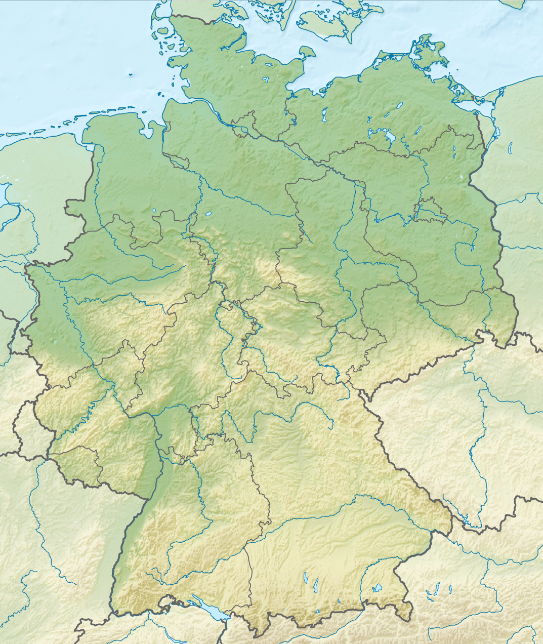
原始文件 (SVG文件,尺寸为1,073 × 1,272像素,文件大小:6.54 MB)
说明
说明
添加一行文字以描述该文件所表现的内容
摘要[编辑]
| 描述 |
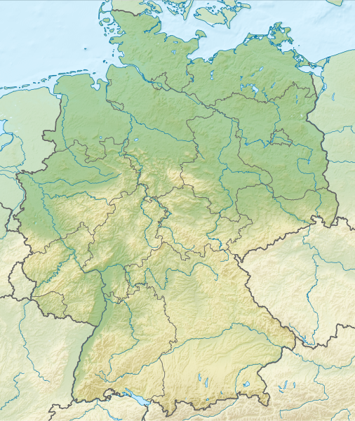
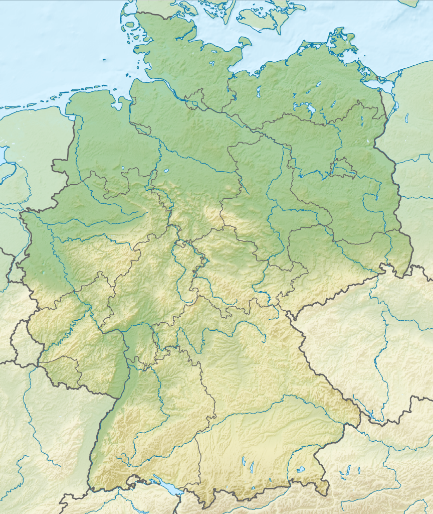
Deutsch: Positionskarte von Deutschland mit Gewässern
Quadratische Plattkarte, N-S-Streckung 150 %. Geographische Begrenzung der Karte:
English: Location map of Germany with waterbodies
Equirectangular projection, N/S stretching 150 %. Geographic limits of the map:
|
| 日期 | |
| 来源 |
自己的作品 |
| 作者 |
TUBS |
| 其他版本 |
Bundesrepublik Deutschland (vor 1990 nur West-Deutschland):
Deutsche Demokratische Republik (mit BRD im Ausschnitt):
Ostdeutschland (vor 1990 Deutsche Demokratische Republik):
Deutschland zwischen Mai 1945 und Oktober 1949:
Thematisch:
Deutsches Reich (1918–1945) (best used with this template (de)):
|
| SVG开发 |


_23_May_1949_-_6_Oct_1949.svg)


_location_map.svg)
_location_map_2013.svg)


许可协议[编辑]
我,本作品著作权人,特此采用以下许可协议发表本作品:
本文件采用知识共享署名-相同方式共享 3.0 未本地化版本许可协议授权。
- 您可以自由地:
- 共享 – 复制、发行并传播本作品
- 修改 – 改编作品
- 惟须遵守下列条件:
- 署名 – 您必须对作品进行署名,提供授权条款的链接,并说明是否对原始内容进行了更改。您可以用任何合理的方式来署名,但不得以任何方式表明许可人认可您或您的使用。
- 相同方式共享 – 如果您再混合、转换或者基于本作品进行创作,您必须以与原先许可协议相同或相兼容的许可协议分发您贡献的作品。

|
如果在维基百科或共享资源之外使用,您将此媒体文件归于维基共享资源,我将不胜感激。要在书籍、报纸、博客、网站等出版物中使用,请插入这以下行:
|
文件历史
点击某个日期/时间查看对应时刻的文件。
| 日期/时间 | 缩略图 | 大小 | 用户 | 备注 | |
|---|---|---|---|---|---|
| 当前 | 2011年12月1日 (四) 14:00 | | 1,073 × 1,272(6.54 MB) | TUBS(留言 | 贡献) |
您不可以覆盖此文件。
文件用途
以下43个页面使用本文件:
- Commons:Files used on RegiowikiAT/9
- Commons:Files used on Wikimedia Österreich Mitglieder/2
- File:Deutschland Autobahnen.svg
- File:East-West-Germany-October 1949-July 1952.svg
- File:East Germany location map.svg
- File:Germany, Federal Republic of location map 23 May 1949 - 6 Oct 1949.svg
- File:Germany, Federal Republic of location map April 1952 - August 1955.svg
- File:Germany, Federal Republic of location map December 1950 - April 1952.svg
- File:Germany, Federal Republic of location map January 1957 - October 1990.svg
- File:Germany, Federal Republic of location map October 1949 - November 1950.svg
- File:Germany, Federal Republic of location map September 1955 - December 1956.svg
- File:Germany, German Democratic Republic location map January 1957 - October 1990.svg
- File:Germany, German Democratic Republic location map July 1952 - January 1957.svg
- File:Germany, German Democratic Republic location map October 1949 - July 1952.svg
- File:Germany, German Democratic Republic location map w·o FRG July 1952 - October 1990.svg
- File:Germany, German Democratic Republic location map w·o FRG October 1949 - June 1952.svg
- File:Germany, location map (SBZ perspective) 23 May 1949 - 6 Oct 1949.svg
- File:Germany2 location map.svg
- File:Germany location map.svg
- File:Germany location map 23 April 1949 - 22 May 1949.svg
- File:Germany location map 8 Jun 1947 - 22 Apr 1949.svg
- File:Germany location map April 1992 - July 1992.svg
- File:Germany location map August 1992 - June 1993.svg
- File:Germany location map July 1993 - December 2009.svg
- File:Germany location map October 1990 - March 1992.svg
- File:Germany location map labeled 8 Jun 1947 - 22 Apr 1949.svg
- File:Lage Freiberg in Deutschland.png
- File:Map Artemia Germany Uwe Manzke.jpg
- File:Map Branchipus schaefferi Germany Uwe Manzke.jpg
- File:Map Chirocephalus diaphanus Germany Uwe Manzke.jpg
- File:Map Eubranchipus grubii Germany Uwe Manzke.jpg
- File:Map Lepidurus apus Germany Uwe Manzke.jpg
- File:Map Leptestheria dahalacensis Germany Uwe Manzke.jpg
- File:Map Limnadia lenticularis Germany Uwe Manzke.jpg
- File:Map Lynceus brachyurus Germany Uwe Manzke.jpg
- File:Map Streptocephalus torvicornis Germany Uwe Manzke.jpg
- File:Map Tanymastix stagnalis Germany Uwe Manzke.jpg
- File:Map Triops cancriformis Germany Uwe Manzke.jpg
- File:Relief Map of Germany.png
- File:Relief Map of Germany.svg
- File:Spielbanken Deutschland.png
- File:Westphalia in Germany FMue.png
- Template:Germany location map/other versions
全域文件用途
以下其他wiki使用此文件:
- an.wikipedia.org上的用途
- ar.wikipedia.org上的用途
- ast.wikipedia.org上的用途
- az.wikipedia.org上的用途
- ban.wikipedia.org上的用途
- Taman Nasional Swiss Saxon
- Taman Nasional Hunsrück-Hochwald
- Taman Nasional Eifel
- Taman Nasional Hainich
- Taman Nasional Kellerwald-Edersee
- Taman Nasional Harz
- Taman Nasional Lebah Oder Sor
- Taman Nasional Müritz
- Taman Nasional Wawengkon Laguna Pomerania Kawan
- Taman Nasional Jasmund
- Taman Nasional Segara Wadden Saxon Sor
- Danu Laacher
- ba.wikipedia.org上的用途
- be.wikipedia.org上的用途
查看本文件的更多全域用途。