File:Route of the old railway line to Upton (geograph 3747367).jpg
Jump to navigation
Jump to search
No higher resolution available.
Route_of_the_old_railway_line_to_Upton_(geograph_3747367).jpg (640 × 426 pixels, file size: 321 KB, MIME type: image/jpeg)
Captions
Captions
Add a one-line explanation of what this file represents
Summary
[edit].jpg&action=edit§ion=1)
| Description |
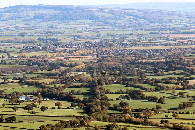
English: Route of the old railway line to Upton - Taken from the "saddle" between the two peaks of Pinnacle Hill on the Malverns.
The avenue of trees running straight away from the camera border the old railway. The spires of both the old and the victorian replacement churches of Upton can be seen in the middle distance. Bredon Hill on the far side of the Severn Plain provides the backdrop with the Cotswold escarpment beyond. |
| Date | |
| Source | From geograph.org.uk |
| Author | Bob Embleton |
| Permission (Reusing this file) |
Creative Commons Attribution Share-alike license 2.0 |
| Attribution (required by the license) | Bob Embleton / Route of the old railway line to Upton / |
| Camera location | | View this and other nearby images on: OpenStreetMap |
|---|
.jpg¶ms=052.075511_N_-002.340063_E_globe:Earth_type:camera_heading:90.00_source:geograph&language=en)
| Object location | | View this and other nearby images on: OpenStreetMap |
|---|
.jpg¶ms=052.068650_N_-002.263800_E_globe:Earth_class:object_type:object_source:geograph-osgb36(SO82014117)_region:GB-GBN_heading:90.00&language=en)
This photograph was taken with a Canon EOS 600D
Licensing
[edit].jpg&action=edit§ion=2)

|
This image was taken from the Geograph project collection. See this photograph's page on the Geograph website for the photographer's contact details. The copyright on this image is owned by Bob Embleton and is licensed for reuse under the Creative Commons Attribution-ShareAlike 2.0 license.
|
This file is licensed under the Creative Commons Attribution-Share Alike 2.0 Generic license.
Attribution: Bob Embleton
- You are free:
- to share – to copy, distribute and transmit the work
- to remix – to adapt the work
- Under the following conditions:
- attribution – You must give appropriate credit, provide a link to the license, and indicate if changes were made. You may do so in any reasonable manner, but not in any way that suggests the licensor endorses you or your use.
- share alike – If you remix, transform, or build upon the material, you must distribute your contributions under the same or compatible license as the original.
File history
Click on a date/time to view the file as it appeared at that time.
| Date/Time | Thumbnail | Dimensions | User | Comment | |
|---|---|---|---|---|---|
| current | 12:17, 1 November 2017 | | 640 × 426 (321 KB) | Seagull123 (talk | contribs) | Transferred from geograph.co.uk using [https://tools.wmflabs.org/geograph2commons/ geograph2commons] |
You cannot overwrite this file.
File usage on Commons
There are no pages that use this file.
.jpg&oldid=545710168)