File:Sabinoso Wilderness (9503869664).jpg

Original file (2,000 × 1,500 pixels, file size: 2.02 MB, MIME type: image/jpeg)
Captions
Captions
Summary
[edit].jpg&action=edit§ion=1)
| Description |
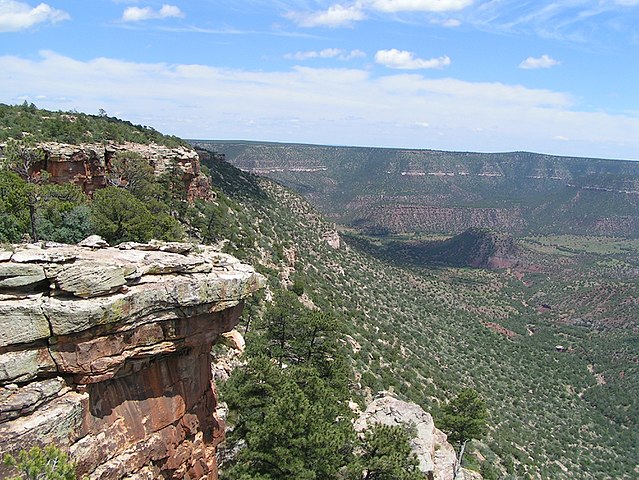
The 16,030-acre Sabinoso Wilderness is a remote area in the northeastern portion of New Mexico. The Wilderness includes a series of high, narrow mesas surrounded by cliff-lined canyons. Elevations range between 4,500 and 6,000 feet above sea level. The rugged country primarily supports piñon pine and juniper woodlands and occasional clusters of ponderosa pine, with a perennial warm season grass savanna on the mesa tops. Streams periodically flow in the canyon bottoms, supporting riparian vegetation including willow and cottonwood. The deep canyon area, surrounded by the wide-open New Mexico plains, is unique for this region. The deep incisions cut by Cañon Olguin, Cañon Largo, and Lagartija Creek create a striking topographical and geological contrast in this otherwise flat terrain. The Bureau of Land Management (BLM) manages the Sabinoso Wilderness to preserve its wilderness character - untrammeled, natural, and undeveloped, with outstanding opportunities for solitude or primitive types of recreation. Wilderness areas are managed in a manner that will leave them unimpaired for future use and enjoyment of these values. There is currently no public access into Sabinoso Wilderness. The BLM is working with nearby landowners who may be willing to provide access. Learn more: www.blm.gov/nm/st/en/prog/wilderness/sabinoso.html |
| Date | |
| Source | Sabinoso Wilderness |
| Author | Bureau of Land Management |
Licensing
[edit].jpg&action=edit§ion=2)
- You are free:
- to share – to copy, distribute and transmit the work
- to remix – to adapt the work
- Under the following conditions:
- attribution – You must give appropriate credit, provide a link to the license, and indicate if changes were made. You may do so in any reasonable manner, but not in any way that suggests the licensor endorses you or your use.
| This image was originally posted to Flickr by mypubliclands at https://flickr.com/photos/91981596@N06/9503869664. It was reviewed on 5 August 2015 by FlickreviewR and was confirmed to be licensed under the terms of the cc-by-2.0. |
| This image is a work of a Bureau of Land Management* employee, taken or made as part of that person's official duties. As a work of the U.S. federal government, the image is in the public domain in the United States. *or predecessor organization |
File history
Click on a date/time to view the file as it appeared at that time.
| Date/Time | Thumbnail | Dimensions | User | Comment | |
|---|---|---|---|---|---|
| current | 19:58, 4 August 2015 | | 2,000 × 1,500 (2.02 MB) | Wilfredor (talk | contribs) | Transferred from Flickr via Flickr2Commons |
You cannot overwrite this file.
File usage on Commons
The following page uses this file:
File usage on other wikis
The following other wikis use this file:
- Usage on en.wikipedia.org
- Usage on it.wikipedia.org
- Usage on www.wikidata.org
.jpg&oldid=875127877)