File:Sagaing Division, Myanmar ESA385422.tiff
Original file (3,521 × 4,144 pixels, file size: 41.77 MB, MIME type: image/tiff)
Captions
Captions
Summary[edit]
| Description |
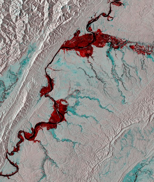
English: The Copernicus Sentinel-1A satellite brings us over part of the Sagaing Division in northwest Myanmar, and along the border with India.
Snaking through the image is the Chindwin River, which breached its banks during a period of severe flooding in 2015. Monsoon rains beginning that July caused multiple rivers in the region to overflow, causing widespread damage and affecting up to a million people. This image was created using two passes by Sentinel-1’s radar: one before the flooding on 20 March 2015 and the other during the event on 4 September 2015. Combining them shows changes between the images, such as the inundation of some 111 000 hectares of land on either sides of the river bank appearing in red. This information was then released in the form of a map under theInternational Charter Space and Major Disastersto assist relief efforts. Currently led by ESA, the Charter is an international collaboration between 16 owners or operators of Earth observation missions. It provides rapid access to satellite data to help disaster management authorities in the event of a natural or man-made disaster. Sentinel-1’s radar ability to ‘see’ through clouds, rain and in darkness makes it particularly useful for monitoring floods. This image is featured on theEarth from Space video programme. |
| Date | |
| Source | http://www.esa.int/spaceinimages/Images/2017/10/Sagaing_Division_Myanmar |
| Author | European Space Agency |
| Permission (Reusing this file) |
contains modified Copernicus Sentinel data (2015), processed by ESA,CC BY-SA 3.0 IGO |
| Other versions |
|
| Title | Sagaing Division, Myanmar |
| Set | Earth observation image of the week |
| System | Copernicus |
| Mission | Sentinel-1 |
| Location | Myanmar |
| Activity | Observing the Earth |
| Keywords | Floods |

Licensing[edit]
- You are free:
- to share – to copy, distribute and transmit the work
- to remix – to adapt the work
- Under the following conditions:
- attribution – You must give appropriate credit, provide a link to the license, and indicate if changes were made. You may do so in any reasonable manner, but not in any way that suggests the licensor endorses you or your use.
- share alike – If you remix, transform, or build upon the material, you must distribute your contributions under the same or compatible license as the original.

|
This image contains data from a satellite in the Copernicus Programme, such as Sentinel-1, Sentinel-2 or Sentinel-3. Attribution is required when using this image.
Attribution: Contains modified Copernicus Sentinel data {{{year}}}
The use of Copernicus Sentinel Data is regulated under EU law (Commission Delegated Regulation (EU) No 1159/2013 and Regulation (EU) No 377/2014). Relevant excerpts:
Free access shall be given to GMES dedicated data [...] made available through GMES dissemination platforms [...].
Access to GMES dedicated data [...] shall be given for the purpose of the following use in so far as it is lawful:
GMES dedicated data [...] may be used worldwide without limitations in time.
GMES dedicated data and GMES service information are provided to users without any express or implied warranty, including as regards quality and suitability for any purpose. |
File history
Click on a date/time to view the file as it appeared at that time.
| Date/Time | Thumbnail | Dimensions | User | Comment | |
|---|---|---|---|---|---|
| current | 15:55, 20 October 2017 |  | 3,521 × 4,144 (41.77 MB) | Fæ (talk | contribs) | European Space Agency, Id 385422, http://www.esa.int/spaceinimages/Images/2017/10/Sagaing_Division_Myanmar, User:Fæ/Project_list/ESA |
You cannot overwrite this file.
File usage on Commons
The following 2 pages use this file: