File:Saint Vincent, particulars of two valuable Sugar Estates - called Waterloo and Orange Hill, situate in the Parish of Charlotte, in the Island of St. Vincent, containing 610 acres, or thereabouts - LOC 2016586600-6.tif
Jump to navigation
Jump to search

Size of this JPG preview of this TIF file: 800 × 510 pixels. Other resolutions: 320 × 204 pixels | 640 × 408 pixels | 1,024 × 653 pixels | 1,280 × 816 pixels | 2,560 × 1,632 pixels | 5,219 × 3,327 pixels.
Original file (5,219 × 3,327 pixels, file size: 49.68 MB, MIME type: image/tiff)
Captions
Captions
Add a one-line explanation of what this file represents
Summary
[edit]| Description |
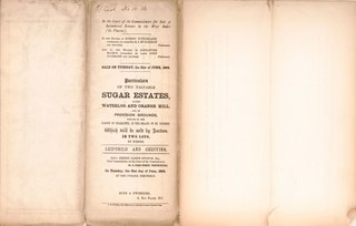
English: Relief shown by hachures. Oriented with north to the right. Title from accompanying text. "Sale on Tuesday, 21st day of June,1864." "In the matter of the Estate of Robert Sutherland (deceased). Ex parte Sir Roderick Impey Murchison, and John Hopton Forbes, petitioners. And in the matter of the Estate of Alexander McLeod (deceased), Ex parte John Cochrane and Thomas Patterson, petitioners." Accompanied by text: In the Court of the Commissioners for Sale of Incumbered Estates in the West Indies, Saint Vincent. ([4] unnumbered pages : cadastral data ; 44 cm, folded to 28 x 12 cm). "Garraway's Coffee House, Change Alley, Cornhill, London, on Monday, the 23rd day of July, 1866, at one o'clock precisely. The purchaser will have an indefeasible Parliamentary Title under the Seal of the Court." Copy imperfect: Use-worn, torn along fold lines, small losses along edges. Available also through the Library of Congress Web site as a raster image. |
||
| Title | Saint Vincent, particulars of two valuable Sugar Estates : called Waterloo and Orange Hill, situate in the Parish of Charlotte, in the Island of St. Vincent, containing 610 acres, or thereabouts : also of certain outlying pieces of land, containing 860 acres, or thereabouts, being valuable provision grounds : which will be sold by auction, in two lots, by Messrs. Leifchild and Cheffins, before Henry James Stonor, Esq. Chief Commissioner, at the Court of the Commissioners. | ||
| Shelf ID | G5121.G46 1864 .L44 | ||
| Parent | https://www.loc.gov/resource/g5121gm.gct00470/ | ||
| Sheet title | Brochure Cover | ||
| Date | |||
| Source | https://www.loc.gov/item/2016586600/ | ||
| Author | Leifchild & Cheffins (Firm); Stonor, Henry James | ||
| Permission (Reusing this file) |
|
||
| Other versions |
|
||
| Location | The Grenadines · Saint Vincent. · Saint Vincent | ||
| Part of | American Memory · Catalog · County Landownership Maps · Geography And Map Division · Cultural Landscapes | ||
| Subject | Cadastral Maps · Sir · Sugarcane · Saint Vincent · Maps · Cust, Reginald John · Saint Vincent And The Grenadines · Owner · Estates · Real Property · Landowners |


Licensing
[edit]|
This is a faithful photographic reproduction of a two-dimensional, public domain work of art. The work of art itself is in the public domain for the following reason:
The official position taken by the Wikimedia Foundation is that "faithful reproductions of two-dimensional public domain works of art are public domain".
This photographic reproduction is therefore also considered to be in the public domain in the United States. In other jurisdictions, re-use of this content may be restricted; see Reuse of PD-Art photographs for details. | ||||
File history
Click on a date/time to view the file as it appeared at that time.
| Date/Time | Thumbnail | Dimensions | User | Comment | |
|---|---|---|---|---|---|
| current | 00:57, 18 May 2018 |  | 5,219 × 3,327 (49.68 MB) | Fæ (talk | contribs) | LOC Maps https://www.loc.gov/item/2016586600/ sheet 6 of 6 #217 |
You cannot overwrite this file.
File usage on Commons
The following page uses this file: