File:Salterhebble tunnels before reopening - geograph.org.uk - 219263.jpg
Jump to navigation
Jump to search

Size of this preview: 395 × 599 pixels. Other resolutions: 158 × 240 pixels | 422 × 640 pixels.
Original file (422 × 640 pixels, file size: 79 KB, MIME type: image/jpeg)
Captions
Captions
Add a one-line explanation of what this file represents
Summary
[edit]
| Description |
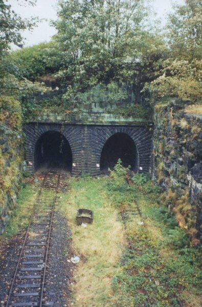
English: Salterhebble tunnels before reopening. These tunnels are on the Halifax – Brighouse leg of the Dryclough Junction – Milner Royd Junction – Greetland Junction triangle of lines. Photographed when the line was disused, it has now reopened. |
| Date | |
| Source | From geograph.org.uk |
| Author | Stephen Craven |
| Attribution (required by the license) | Stephen Craven / Bankhouse tunnels before reopening / |
| Camera location | | View this and other nearby images on: OpenStreetMap |
|---|
_heading:180.00&language=en)
| Object location | | View this and other nearby images on: OpenStreetMap |
|---|
_heading:180.00&language=en)
Licensing
[edit]

|
This image was taken from the Geograph project collection. See this photograph's page on the Geograph website for the photographer's contact details. The copyright on this image is owned by Stephen Craven and is licensed for reuse under the Creative Commons Attribution-ShareAlike 2.0 license.
|
This file is licensed under the Creative Commons Attribution-Share Alike 2.0 Generic license.
Attribution: Stephen Craven
- You are free:
- to share – to copy, distribute and transmit the work
- to remix – to adapt the work
- Under the following conditions:
- attribution – You must give appropriate credit, provide a link to the license, and indicate if changes were made. You may do so in any reasonable manner, but not in any way that suggests the licensor endorses you or your use.
- share alike – If you remix, transform, or build upon the material, you must distribute your contributions under the same or compatible license as the original.
File history
Click on a date/time to view the file as it appeared at that time.
| Date/Time | Thumbnail | Dimensions | User | Comment | |
|---|---|---|---|---|---|
| current | 20:10, 31 January 2010 | | 422 × 640 (79 KB) | GeographBot (talk | contribs) | == {{int:filedesc}} == {{Information |description={{en|1=Bankhouse tunnels before reopening. These tunnels take the Halifax-Huddersfield line under the A629 at Crossley Hill. Photographed when the line was disused, it has now reopened.}} |date=1998-10-17 |
You cannot overwrite this file.
File usage on Commons
The following 2 pages use this file:
File usage on other wikis
The following other wikis use this file:
- Usage on www.wikidata.org