File:Sanctuary marker, Holyrood Abbey - geograph.org.uk - 1336716.jpg
Jump to navigation
Jump to search
Size of this preview: 450 × 600 pixels. Other resolutions: 180 × 240 pixels | 480 × 640 pixels.
Original file (480 × 640 pixels, file size: 118 KB, MIME type: image/jpeg)
Captions
Captions
Add a one-line explanation of what this file represents
Summary
[edit]
| Description |
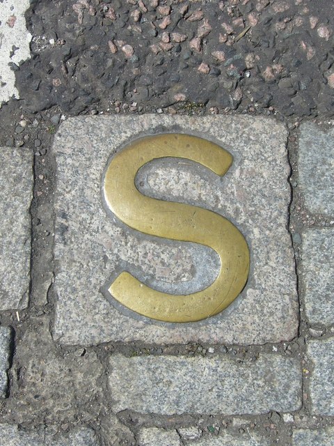
English: Sanctuary marker, Holyrood Abbey One of three brass markers in the roadway outside Holyrood Palace, delineating the former sanctuary boundary of Holyrood Abbey. Although records go back further, the policy of granting sanctuary to debtors appears to have been formalised after Charles I appointed the Duke of Hamilton and his heirs to be Keepers of the Palace in 1646. The 'abbey lairds', as the debtors were called, enjoyed the privilege of being allowed to leave the sanctuary between midnight on Saturday and midnight on Sunday without fear of arrest. Their number included Thomas de Quincey, author of Confessions of an English Opium Eater, who lived within the sanctuary at various times between 1833 and 1840. Another famous resident was Charles-Philippe, Comte d'Artois, brother of the deposed Louis XVIII of France. His first arrival in 1796 was prompted by the massive debts he had incurred supplying the émigré army after the French Revolution. He returned in 1830 after reigning briefly as Charles X, complete with his retinue of a hundred, most of whom lodged in the Canongate. But the political climate in Britain was changing at the time of the 1832 Reform Act and this induced him to leave, embarking from the Chain Pier near Newhaven on a steam-boat to Hamburg. The last occasion a person sought sanctuary at Holyrood was in 1880. |
| Date | |
| Source | From geograph.org.uk |
| Author | kim traynor |
| Attribution (required by the license) | kim traynor / Sanctuary marker, Holyrood Abbey / |
| Camera location | | View this and other nearby images on: OpenStreetMap |
|---|
_heading:247.00&language=en)
| Object location | | View this and other nearby images on: OpenStreetMap |
|---|
_heading:247.00&language=en)
Licensing
[edit]

|
This image was taken from the Geograph project collection. See this photograph's page on the Geograph website for the photographer's contact details. The copyright on this image is owned by kim traynor and is licensed for reuse under the Creative Commons Attribution-ShareAlike 2.0 license.
|
This file is licensed under the Creative Commons Attribution-Share Alike 2.0 Generic license.
Attribution: kim traynor
- You are free:
- to share – to copy, distribute and transmit the work
- to remix – to adapt the work
- Under the following conditions:
- attribution – You must give appropriate credit, provide a link to the license, and indicate if changes were made. You may do so in any reasonable manner, but not in any way that suggests the licensor endorses you or your use.
- share alike – If you remix, transform, or build upon the material, you must distribute your contributions under the same or compatible license as the original.
File history
Click on a date/time to view the file as it appeared at that time.
| Date/Time | Thumbnail | Dimensions | User | Comment | |
|---|---|---|---|---|---|
| current | 02:14, 28 February 2011 | | 480 × 640 (118 KB) | GeographBot (talk | contribs) | == {{int:filedesc}} == {{Information |description={{en|1=Sanctuary marker, Holyrood Abbey One of three brass markers in the roadway outside Holyrood Palace, delineating the former sanctuary boundary of Holyrood Abbey. Although records go back further, the |
You cannot overwrite this file.
File usage on Commons
There are no pages that use this file.
File usage on other wikis
The following other wikis use this file:
- Usage on en.wikipedia.org
- Usage on nl.wikipedia.org