File:Schmettau Blabbergraben Nord.jpg
Jump to navigation
Jump to search

Size of this preview: 485 × 599 pixels. Other resolutions: 194 × 240 pixels | 388 × 480 pixels | 963 × 1,190 pixels.
Original file (963 × 1,190 pixels, file size: 843 KB, MIME type: image/jpeg)
Captions
Captions
Add a one-line explanation of what this file represents
Summary
[edit]
| Description |
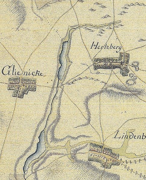
Deutsch: Ausschnitt aus dem Schmettauschen Kartenwerk von 1767/1787 im heutigen im Landkreis Oder-Spree in Brandenburg. Die Karte zeigt die Dörfer Herzberg, Glienicke (heute Ortsteile der Gemeinde Rietz-Neuendorf) und Lindenberg (Ortsteil der Gemeinde Tauche) und den nördlichen Teil des Blabbergrabens mit dem Herzberger See und Lindenberger See. Der obere Teil des Blabbergrabens (Zufluss zum Herzberger See) ist nur noch mit einem Teilstück vorhanden, das rund 550 Meter vor dem Nordufer versickert. Stattdessen wird heute ein rund 270 Meter langer Wasserlauf, der östlich des Sees an der Herzberger Straße „Am See“ beginnt und rund 200 Meter südlich des Nordufers am Ostufer in den See mündet, als Blabbergraben bezeichnet. Dieser Wasserlauf ist in der Schmettauschen Karte nicht enthalten.
English: Extract of a Schmettau map from 1767/1787 with a part of the today’s District Oder-Spree, Brandenburg, Germany. The map shows the villages Herzberg, Glienicke (today parts of the municipality Rietz-Neuendorf) and Lindenberg (part of the municipality Tauche). It shows also the northern part of the Blabbergraben with the Herzberger lake und Lindenberger lake. Today, the first part of the Blabbergraben towards the Herzberger See exists still in a rudimentary form. |
|||||||||||||||||||
| Date | between 1767 and 1787 | |||||||||||||||||||
| Source | Schmettausches Kartenwerk, 1:50.000, Blatt Brandenburg-Sektion 91, Franckfurth (1767–1787) | |||||||||||||||||||
| Author |
|
|||||||||||||||||||
Licensing
[edit]
|
This is a faithful photographic reproduction of a two-dimensional, public domain work of art. The work of art itself is in the public domain for the following reason:
The official position taken by the Wikimedia Foundation is that "faithful reproductions of two-dimensional public domain works of art are public domain".
This photographic reproduction is therefore also considered to be in the public domain in the United States. In other jurisdictions, re-use of this content may be restricted; see Reuse of PD-Art photographs for details. | ||||
File history
Click on a date/time to view the file as it appeared at that time.
| Date/Time | Thumbnail | Dimensions | User | Comment | |
|---|---|---|---|---|---|
| current | 15:24, 24 October 2014 | | 963 × 1,190 (843 KB) | Lienhard Schulz (talk | contribs) | {{Information |description= {{de|Ausschnitt aus dem Schmettauschen Kartenwerk von 1767/1787 im heutigen im Landkreis Oder-Spree in Brandenburg. Die Karte zeigt die Dörfer [[:Cate... |
You cannot overwrite this file.
File usage on Commons
There are no pages that use this file.
File usage on other wikis
The following other wikis use this file:
- Usage on de.wikipedia.org