File:Semmering - Adlitzgräben mit Semmeringbahn.JPG
Jump to navigation
Jump to search

Size of this preview: 800 × 450 pixels. Other resolutions: 320 × 180 pixels | 640 × 360 pixels | 1,024 × 576 pixels | 1,280 × 720 pixels | 2,560 × 1,440 pixels | 5,200 × 2,925 pixels.
Original file (5,200 × 2,925 pixels, file size: 8.85 MB, MIME type: image/jpeg)
Captions
Captions
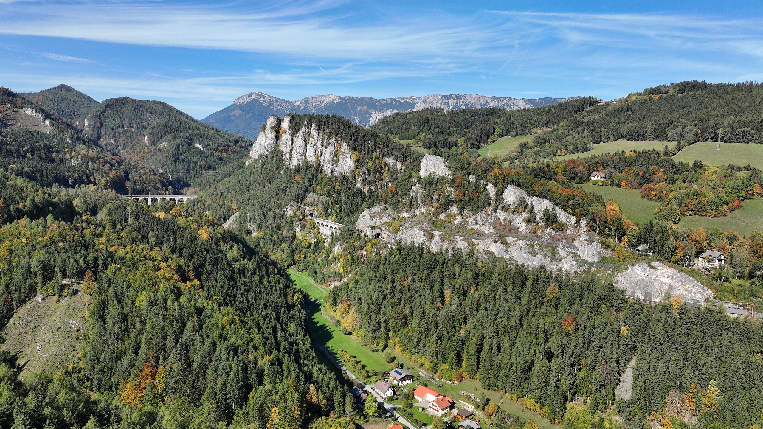
The heart of the Semmering Railway in Lower Austria.
Summary[edit]
| Description |
Deutsch: Blick vom Wolfsbergkogel in der niederösterreichischen Gemeinde Semmering auf das „Kernstück“ der Semmeringbahn im Adlitzgraben bzw. Kalte Rinne mit dem (von links nach rechts) Viadukt über die Kalte Rinne, dem Polleres-Tunnel unterhalb der Pollereswand, dem Krausel-Klause-Viadukt sowie dem kleinen Krausel-Tunnel unterhalb der Spießwand und im Hintergrund das Rax-Massiv mit der höchsten Erhebung, der 2007 m hohen Heukuppe. Diese Ansicht ist auch als „20-Schilling-Blick“ bekannt, da sie auf der Rückseite der 20-Schilling-Note dargestellt war. Die Semmeringbahn, geplant von Carl von Ghega, war die erste normalspurige Gebirgsbahn Europas und wurde 1854 eröffnet.
English: The heart of the Semmering Railway in Lower Austria. |
| Date | |
| Source | Own work |
| Author | C.Stadler/Bwag |
| Permission (Reusing this file) |
Deutsch: Hallo, du darfst mein Foto kostenlos nutzen, aber nenne mich bitte als Fotograf, beispielsweise „Foto: C.Stadler/Bwag“ oder © C.Stadler/Bwag; CC-BY-SA-4.0. Auf mehr Angaben bestehe ich nicht - im Gegensatz zu manch anderen, die die Vorgaben der unten angeführten Lizenzierung auf Punkt und Beistrich einfordern. English: Feel free to use my photos, but please mention me as the author like © C.Stadler/Bwag or © C.Stadler/Bwag; CC-BY-SA-4.0 (that's good enough) and if you want send me a message: bwag@gmx.net. |
| Other versions |
|


| Object location | | View this and other nearby images on: OpenStreetMap |
|---|
| Camera location | | View this and other nearby images on: OpenStreetMap |
|---|
Licensing[edit]
I, the copyright holder of this work, hereby publish it under the following license:
This file is licensed under the Creative Commons Attribution-Share Alike 4.0 International license.
- You are free:
- to share – to copy, distribute and transmit the work
- to remix – to adapt the work
- Under the following conditions:
- attribution – You must give appropriate credit, provide a link to the license, and indicate if changes were made. You may do so in any reasonable manner, but not in any way that suggests the licensor endorses you or your use.
- share alike – If you remix, transform, or build upon the material, you must distribute your contributions under the same or compatible license as the original.
File history
Click on a date/time to view the file as it appeared at that time.
| Date/Time | Thumbnail | Dimensions | User | Comment | |
|---|---|---|---|---|---|
| current | 20:36, 19 March 2023 | | 5,200 × 2,925 (8.85 MB) | Bwag (talk | contribs) | == {{int:filedesc}} == {{Information |Description= {{de|1= Blick vom Wolfsbergkogel in der niederösterreichischen Gemeinde Semmering auf das „Kernstück“ der Semmeringbahn im Adlitzgraben bzw. ''Kalte Rinne'' mit dem (von links nach rechts) Viadukt über die Kalte Rinne, dem Polleres-Tunnel unterhalb der Pollereswand, dem Krausel-Klause-Viadukt sowie dem kleinen Krausel-Tunnel unterhalb der Spießwand und im Hintergrund das Rax-Massiv mit der höchsten Erhebung, der 2007 m hohen Heukuppe. Diese... |
You cannot overwrite this file.
File usage on Commons
The following 2 pages use this file:
File usage on other wikis
The following other wikis use this file:
- Usage on sl.wikipedia.org
- Usage on vi.wikipedia.org