File:Sir Robert Peel's Mill, Fazeley - geograph.org.uk - 675646.jpg
Jump to navigation
Jump to search
No higher resolution available.
Sir_Robert_Peel's_Mill,_Fazeley_-_geograph.org.uk_-_675646.jpg (640 × 427 pixels, file size: 75 KB, MIME type: image/jpeg)
Captions
Captions
Add a one-line explanation of what this file represents
Summary[edit]
| Description |
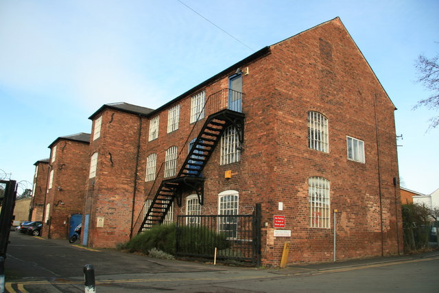
English: Sir Robert Peel's Mill, Fazeley Fazeley formed part of the estate that Peel bought in 1790 as part of his Tamworth parliamentary package. The Old Mill was opened in 1790 for cotton spinning and calico printing and was water powered. The building is 3 storeys high and at first was 8 bays but a further 11 were added. The Peel family ended its connection with the mills in 1841. Fred Brook - Industrial Archaeology of the West Midlands (1977). |
| Date | |
| Source | From geograph.org.uk |
| Author | Chris Allen |
| Attribution (required by the license) | Chris Allen / Sir Robert Peel's Mill, Fazeley / |
| Camera location | | View this and other nearby images on: OpenStreetMap |
|---|
_heading:315.00&language=en)
| Object location | | View this and other nearby images on: OpenStreetMap |
|---|
_heading:315.00&language=en)
Licensing[edit]

|
This image was taken from the Geograph project collection. See this photograph's page on the Geograph website for the photographer's contact details. The copyright on this image is owned by Chris Allen and is licensed for reuse under the Creative Commons Attribution-ShareAlike 2.0 license.
|
This file is licensed under the Creative Commons Attribution-Share Alike 2.0 Generic license.
Attribution: Chris Allen
- You are free:
- to share – to copy, distribute and transmit the work
- to remix – to adapt the work
- Under the following conditions:
- attribution – You must give appropriate credit, provide a link to the license, and indicate if changes were made. You may do so in any reasonable manner, but not in any way that suggests the licensor endorses you or your use.
- share alike – If you remix, transform, or build upon the material, you must distribute your contributions under the same or compatible license as the original.
File history
Click on a date/time to view the file as it appeared at that time.
| Date/Time | Thumbnail | Dimensions | User | Comment | |
|---|---|---|---|---|---|
| current | 23:15, 7 February 2011 | | 640 × 427 (75 KB) | GeographBot (talk | contribs) | == {{int:filedesc}} == {{Information |description={{en|1=Sir Robert Peel's Mill, Fazeley Fazeley formed part of the estate that Peel bought in 1790 as part of his Tamworth parliamentary package. The Old Mill was opened in 1790 for cotton spinning and cal |
You cannot overwrite this file.
File usage on Commons
There are no pages that use this file.
File usage on other wikis
The following other wikis use this file:
- Usage on en.wikipedia.org
- Usage on www.wikidata.org