File:Site of Holden Cross - geograph.org.uk - 482170.jpg
Jump to navigation
Jump to search
No higher resolution available.
Site_of_Holden_Cross_-_geograph.org.uk_-_482170.jpg (640 × 480 pixels, file size: 100 KB, MIME type: image/jpeg)
Captions
Captions
Add a one-line explanation of what this file represents
Summary
[edit]
| Description |
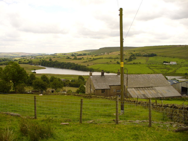
English: Site of Holden Cross. The corner of the field above Leys Farm was once the site of the ancient Holden Cross. It is believed that this was one of a line of crosses marking the way from Manchester to Whalley Abbey. The photo looks south and on the moors in the background was sited another cross, Holcombe Pilgrims Cross 238469 on the same route. Many years ago Holden Cross shaft disappeared and only the socketed base remained. About 1915 the base was moved by Major Halstead M.P., Mayor of Haslingden, and now leans against the clock tower in Victoria Park, Haslingden. 482253 |
| Date | |
| Source | From geograph.org.uk |
| Author | Peter Worrell |
| Attribution (required by the license) | Peter Worrell / Site of Holden Cross / |
| Camera location | | View this and other nearby images on: OpenStreetMap |
|---|
_heading:180.00&language=en)
| Object location | | View this and other nearby images on: OpenStreetMap |
|---|
_heading:180.00&language=en)
Licensing
[edit]

|
This image was taken from the Geograph project collection. See this photograph's page on the Geograph website for the photographer's contact details. The copyright on this image is owned by Peter Worrell and is licensed for reuse under the Creative Commons Attribution-ShareAlike 2.0 license.
|
This file is licensed under the Creative Commons Attribution-Share Alike 2.0 Generic license.
Attribution: Peter Worrell
- You are free:
- to share – to copy, distribute and transmit the work
- to remix – to adapt the work
- Under the following conditions:
- attribution – You must give appropriate credit, provide a link to the license, and indicate if changes were made. You may do so in any reasonable manner, but not in any way that suggests the licensor endorses you or your use.
- share alike – If you remix, transform, or build upon the material, you must distribute your contributions under the same or compatible license as the original.
File history
Click on a date/time to view the file as it appeared at that time.
| Date/Time | Thumbnail | Dimensions | User | Comment | |
|---|---|---|---|---|---|
| current | 02:38, 5 February 2011 | | 640 × 480 (100 KB) | GeographBot (talk | contribs) | == {{int:filedesc}} == {{Information |description={{en|1=Site of Holden Cross The corner of the field above Leys Farm was once the site of the ancient Holden Cross. It is believed that this was one of a line of crosses marking the way from Manchester to |
You cannot overwrite this file.
File usage on Commons
There are no pages that use this file.