File:Sketch showing the positions of the redoubts and batteries of the lines of the U.S. Forces in front of Petersburg LOC 2007627332.tif
Jump to navigation
Jump to search

Size of this JPG preview of this TIF file: 516 × 599 pixels. Other resolutions: 207 × 240 pixels | 413 × 480 pixels | 661 × 768 pixels | 881 × 1,024 pixels | 1,763 × 2,048 pixels | 6,811 × 7,913 pixels.
Original file (6,811 × 7,913 pixels, file size: 154.2 MB, MIME type: image/tiff)
Captions
Captions
Add a one-line explanation of what this file represents
Summary
[edit]| Description |
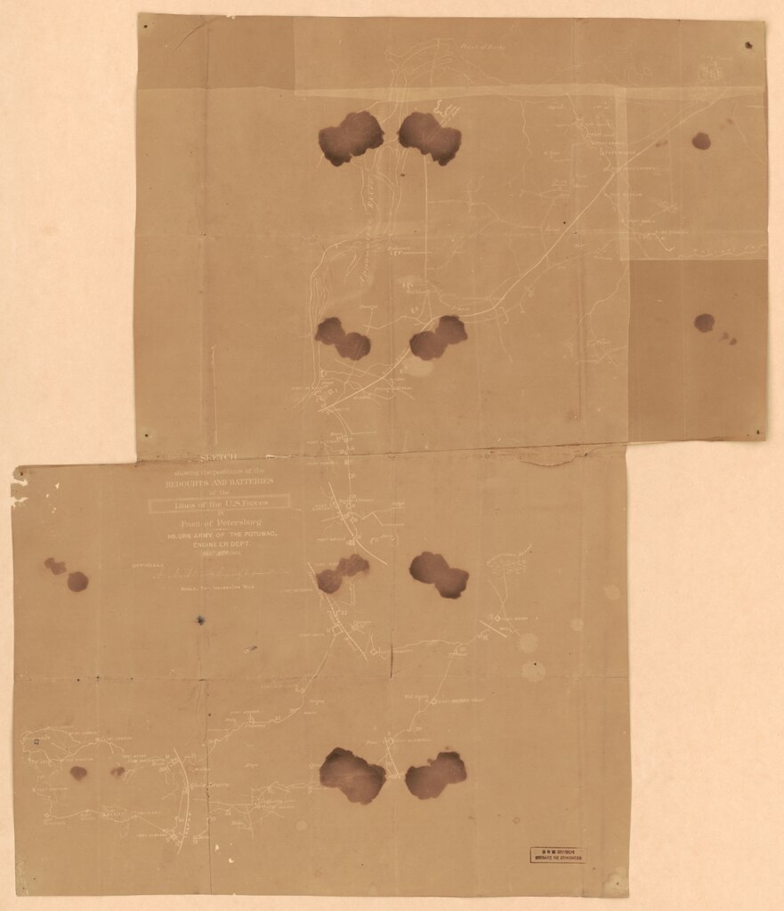
English: Shows fortifications and names of some residents. Sun print with pencil annotations, on irregularly shaped brown paper made from 2 sheets unevenly pasted together. Transferred from the Joseph Warren Keifer Papers in the Manuscript Division, L.C. Following the word "Official:" is an effaced inscription "N. Michler ... [illegible]". LC copy imperfect: Holes and liquid staining throughout. Torn right edge along fold line. Available also through the Library of Congress Web site as a raster image. Acquisitions control no.: 1995-39. |
||
| Title | Sketch showing the positions of the redoubts and batteries of the lines of the U.S. Forces in front of Petersburg | ||
| Shelf ID | G3884.P4S5 1864 .U53 | ||
| Date | |||
| Source | https://www.loc.gov/item/2007627332/ | ||
| Author | United States. Army Of The Potomac. Engineer Department | ||
| Permission (Reusing this file) |
|
||
| Other versions |
|
||
| Location | United States · Petersburg Region · Virginia | ||
| Part of | Military Battles And Campaigns · American Memory · Civil War Maps · Catalog · Geography And Map Division | ||
| Subject | Petersburg Region · Fortification · Virginia · Civil War · United States · Maps · Landowners · Petersburg Region (Va.) · History |


Licensing
[edit]|
This is a faithful photographic reproduction of a two-dimensional, public domain work of art. The work of art itself is in the public domain for the following reason:
The official position taken by the Wikimedia Foundation is that "faithful reproductions of two-dimensional public domain works of art are public domain".
This photographic reproduction is therefore also considered to be in the public domain in the United States. In other jurisdictions, re-use of this content may be restricted; see Reuse of PD-Art photographs for details. | ||||
File history
Click on a date/time to view the file as it appeared at that time.
| Date/Time | Thumbnail | Dimensions | User | Comment | |
|---|---|---|---|---|---|
| current | 09:44, 20 May 2018 |  | 6,811 × 7,913 (154.2 MB) | Fæ (talk | contribs) | LOC Maps https://www.loc.gov/item/2007627332/ #12197 |
You cannot overwrite this file.
File usage on Commons
The following page uses this file: