File:Sleaford Trains Illustrated Fenland Rail Tour geograph-2827296-by-Ben-Brooksbank.jpg
Jump to navigation
Jump to search

Size of this preview: 800 × 581 pixels. Other resolutions: 320 × 232 pixels | 640 × 465 pixels | 1,024 × 744 pixels | 1,280 × 930 pixels | 1,993 × 1,448 pixels.
Original file (1,993 × 1,448 pixels, file size: 1.27 MB, MIME type: image/jpeg)
Captions
Captions
Add a one-line explanation of what this file represents
Summary
[edit]
| Description |
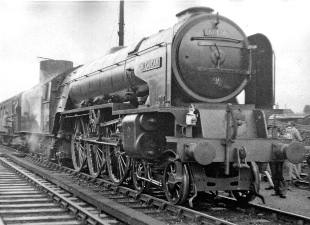
English: A1 Pacific heads Trains Illustrated Fenland Rail Tour at Sleaford. View eastward, towards Spalding on the ex-GN&GE March - Spalding - Sleaford - Lincoln - Doncaster main line, also ex-GN Lincoln - Boston line. The complex Tour took us from Liverpool Street to Norwich, then Cromer and over the M&GN via Melton Constable and South Lynn to Spalding, then via Sleaford and Grantham back to King's Cross. A1 4-6-2 No. 60136 'Alcazar' (built 11/48, withdrawn 5/63) took over here for the last leg via Grantham to London. |
| Date | |
| Source | From geograph.org.uk |
| Author | Ben Brooksbank |
| Permission (Reusing this file) |
Creative Commons Attribution Share-alike license 2.0 |
| Attribution (required by the license) | Ben Brooksbank / A1 Pacific heads Trains Illustrated Fenland Rail Tour at Sleaford / |
| Camera location | | View this and other nearby images on: OpenStreetMap |
|---|
Licensing
[edit]

|
This image was taken from the Geograph project collection. See this photograph's page on the Geograph website for the photographer's contact details. The copyright on this image is owned by Ben Brooksbank and is licensed for reuse under the Creative Commons Attribution-ShareAlike 2.0 license.
|
This file is licensed under the Creative Commons Attribution-Share Alike 2.0 Generic license.
Attribution: Ben Brooksbank
- You are free:
- to share – to copy, distribute and transmit the work
- to remix – to adapt the work
- Under the following conditions:
- attribution – You must give appropriate credit, provide a link to the license, and indicate if changes were made. You may do so in any reasonable manner, but not in any way that suggests the licensor endorses you or your use.
- share alike – If you remix, transform, or build upon the material, you must distribute your contributions under the same or compatible license as the original.
File history
Click on a date/time to view the file as it appeared at that time.
| Date/Time | Thumbnail | Dimensions | User | Comment | |
|---|---|---|---|---|---|
| current | 11:35, 21 March 2012 | | 1,993 × 1,448 (1.27 MB) | Chevin (talk | contribs) | == {{int:filedesc}} == {{Information |Description={{en|1='''A1 Pacific heads Trains Illustrated Fenland Rail Tour at Sleaford.'''<br/> View eastward, towards Spalding on the ex-GN&GE March - Spalding - Sleaford - Lincoln - Doncaster main line, also ex-... |
You cannot overwrite this file.
File usage on Commons
There are no pages that use this file.
File usage on other wikis
The following other wikis use this file:
- Usage on en.wikipedia.org