File:Soaybaskingsharkfisheries.jpg
Jump to navigation
Jump to search
No higher resolution available.
Soaybaskingsharkfisheries.jpg (640 × 425 pixels, file size: 307 KB, MIME type: image/jpeg)
Captions
Captions
Add a one-line explanation of what this file represents
Summary
[edit]| Description |
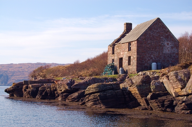
The Island of Soay Shark Fisheries Ltd The basking shark fishing station was established here in Soay Harbour by Gavin Maxwell, on a small island off Skye. It operated between 1945 and 1948, when it collapsed financially, having caught around 1,000 sharks. The huge carcasses were pulled out of the water here, the livers rendered for oil, the rest sold for fertilizer, aphrodisiacs or food. A glorious failure of an enterprise. Not to be confused with Soay in St Kilda, or Soay in the Outer Hebrides. |
||
| Date | See image source page. | ||
| Source |
This image was taken from the Geograph project collection. See this photograph's page on the Geograph website for the photographer's contact details. The copyright on this image is owned by John Allan and is licensed for reuse under the Creative Commons Attribution-ShareAlike 2.0 license.
This file is licensed under the Creative Commons Attribution-Share Alike 2.0 Generic license. Attribution: John Allan
|
||
| Author | See above. | ||
| Permission (Reusing this file) |
See above. |

| Camera location | | View this and other nearby images on: OpenStreetMap |
|---|
| Object location | | View this and other nearby images on: OpenStreetMap |
|---|
_region:GB-SCT_heading:45.00&language=en)
Licensing
[edit]
This file is licensed under the Creative Commons Attribution-Share Alike 2.0 Generic license.
- You are free:
- to share – to copy, distribute and transmit the work
- to remix – to adapt the work
- Under the following conditions:
- attribution – You must give appropriate credit, provide a link to the license, and indicate if changes were made. You may do so in any reasonable manner, but not in any way that suggests the licensor endorses you or your use.
- share alike – If you remix, transform, or build upon the material, you must distribute your contributions under the same or compatible license as the original.
File history
Click on a date/time to view the file as it appeared at that time.
| Date/Time | Thumbnail | Dimensions | User | Comment | |
|---|---|---|---|---|---|
| current | 17:50, 22 November 2007 | | 640 × 425 (307 KB) | MacRusgail (talk | contribs) | == Summary == {{Information |Description=The Island of Soay Shark Fisheries Ltd The basking shark fishing station was established here in Soay Harbour by Gavin Maxwell, on a small island off Skye. It operated between 1945 and 1948, when it collapsed finan |
You cannot overwrite this file.
File usage on Commons
There are no pages that use this file.
File usage on other wikis
The following other wikis use this file:
- Usage on ca.wikipedia.org
- Usage on ceb.wikipedia.org
- Usage on de.wikipedia.org
- Usage on el.wikipedia.org
- Usage on en.wikipedia.org
- Usage on ga.wikipedia.org
- Usage on gd.wikipedia.org
- Usage on it.wikipedia.org
- Usage on nn.wikipedia.org
- Usage on ru.wikipedia.org
- Usage on www.wikidata.org
- Usage on zh.wikipedia.org