File:Soldiers Lump, Black Hill - geograph.org.uk - 131693.jpg
Jump to navigation
Jump to search
No higher resolution available.
Soldiers_Lump,_Black_Hill_-_geograph.org.uk_-_131693.jpg (640 × 480 pixels, file size: 73 KB, MIME type: image/jpeg)
Captions
Captions
Add a one-line explanation of what this file represents
Summary
[edit]
| Description |
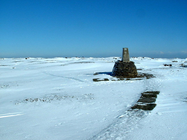
English: Soldiers Lump, Black Hill. The trig point (TP3980 - Holme Moss) and highest point on Black Hill is on a small elevated mound, called Soldiers' Lump. As well as the path even the trig point has been given a makeover with a neat beehive of flat stones to hide the exposed ragged concrete plinth. See 131721 for how it used to be |
| Date | |
| Source | From geograph.org.uk |
| Author | Nigel Homer |
| Attribution (required by the license) | Nigel Homer / Soldiers Lump, Black Hill / |
| Object location | | View this and other nearby images on: OpenStreetMap |
|---|
_&language=en)
Licensing
[edit]

|
This image was taken from the Geograph project collection. See this photograph's page on the Geograph website for the photographer's contact details. The copyright on this image is owned by Nigel Homer and is licensed for reuse under the Creative Commons Attribution-ShareAlike 2.0 license.
|
This file is licensed under the Creative Commons Attribution-Share Alike 2.0 Generic license.
Attribution: Nigel Homer
- You are free:
- to share – to copy, distribute and transmit the work
- to remix – to adapt the work
- Under the following conditions:
- attribution – You must give appropriate credit, provide a link to the license, and indicate if changes were made. You may do so in any reasonable manner, but not in any way that suggests the licensor endorses you or your use.
- share alike – If you remix, transform, or build upon the material, you must distribute your contributions under the same or compatible license as the original.
File history
Click on a date/time to view the file as it appeared at that time.
| Date/Time | Thumbnail | Dimensions | User | Comment | |
|---|---|---|---|---|---|
| current | 06:14, 31 January 2010 | | 640 × 480 (73 KB) | GeographBot (talk | contribs) | == {{int:filedesc}} == {{Information |description={{en|1=Soldiers Lump, Black Hill. The trig point (TP3980 - Holme Moss) and highest point on Black Hill is on a small elevated mound, called Soldiers' Lump. As well as the path even the trig point has been |
You cannot overwrite this file.
File usage on Commons
There are no pages that use this file.