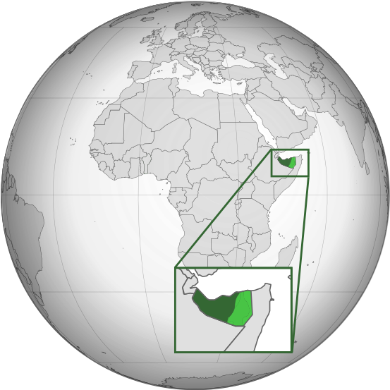
File:Somaliland (orthographic projection).svg

Rozmiar pierwotny (Plik SVG, nominalnie 553 × 553 pikseli, rozmiar pliku: 274 KB)
Podpisy
Podpisy
The self-proclaimed government of Somaliland no longer controls the Sool, Sanaag, and Cayn (Buhoodle) region of Somalia
Opis[edytuj]
| OpisSomaliland (orthographic projection).svg |
English: Somaliland (orthographic projection) |
| Data | |
| Źródło | Derivative work of File:Benin (orthographic projection with inset).svg |
| Autor | Flappiefh with some additional modifications by Offnfopt |
! / mode mimi_ext
Contrôle7 104 rosemarose moh_dado@hotmail.com S**100*3H00[DE ES T]
Licencja[edytuj]
- Wolno:
- dzielić się – kopiować, rozpowszechniać, odtwarzać i wykonywać utwór
- modyfikować – tworzyć utwory zależne
- Na następujących warunkach:
- uznanie autorstwa – musisz określić autorstwo utworu, podać link do licencji, a także wskazać czy utwór został zmieniony. Możesz to zrobić w każdy rozsądny sposób, o ile nie będzie to sugerować, że licencjodawca popiera Ciebie lub Twoje użycie utworu.
- na tych samych warunkach – Jeśli zmienia się lub przekształca niniejszy utwór, lub tworzy inny na jego podstawie, można rozpowszechniać powstały w ten sposób nowy utwór tylko na podstawie tej samej lub podobnej licencji.
Historia pliku
Kliknij na odpowiedniej dacie/czasie, aby zobaczyć wersję pliku z tamtego okresu.
| Data/czas | Miniatura | Wymiary | Użytkownik | Opis | |
|---|---|---|---|---|---|
| aktualny | 09:17, 28 mar 2024 |  | 553 × 553 (274 KB) | Alaexis (dyskusja | edycje) | I believe that this version is better; it simply marks the disputed area without saying who controls it; see these articles with similar maps https://www.economist.com/middle-east-and-africa/2021/05/06/somaliland-an-unrecognised-state-is-winning-friends-abroad https://www.thehindu.com/news/international/ethiopia-breakaway-somaliland-sign-port-deal-somalias-cabinet-calls-emergency-meet/article67697822.ece |
| 18:49, 20 sty 2024 |  | 553 × 553 (250 KB) | Buufin (dyskusja | edycje) | Reverted to version as of 23:17, 1 October 2023 (UTC)Vandalism | |
| 07:37, 20 sty 2024 |  | 553 × 553 (274 KB) | QalasQalas (dyskusja | edycje) | Reverted to version as of 14:53, 27 September 2023 (UTC) | |
| 23:17, 1 paź 2023 |  | 553 × 553 (250 KB) | Subayerboombastic (dyskusja | edycje) | I believe it is premature to label all of the territory now claimed by Khatumo as being uncontrolled by Somaliland. It is notoriously difficult to get a clear picture of the the facts on the ground for this conflict. All that is known for sure is that Somaliland forces were pushed out of Las Anod and are currently stationed in Oog. It is unclear if Khatumo forces have managed affect control over towns in the region such as Hudan or Taleh or if Somaliland's governmental structure is still in p... | |
| 04:09, 29 wrz 2023 |  | 553 × 553 (277 KB) | Billboardbillal (dyskusja | edycje) | Subayerboombastic deleted my upload without explanation and without an edit summary | |
| 03:50, 29 wrz 2023 |  | 553 × 553 (250 KB) | Subayerboombastic (dyskusja | edycje) | Reverted to version as of 16:59, 28 September 2023 (UTC) | |
| 18:33, 28 wrz 2023 |  | 553 × 553 (277 KB) | Billboardbillal (dyskusja | edycje) | shaded west Xudun and Erigabo district and Aynabo up to Oog as Somaliland controlled | |
| 16:59, 28 wrz 2023 |  | 553 × 553 (250 KB) | Seepsimon (dyskusja | edycje) | Reverted to version as of 05:21, 27 September 2023 (UTC) both caynaba and western xudun and South western ceerigabo is controlled by Somaliland. Go to Google map and see how caynaba and buhoodle are shaded each other. You have to make accurate map other wise stop the vandalizing. | |
| 14:53, 27 wrz 2023 |  | 553 × 553 (274 KB) | Billboardbillal (dyskusja | edycje) | updated whilst removing Aynabo according to Seepsimon suggestion | |
| 05:21, 27 wrz 2023 |  | 553 × 553 (250 KB) | Seepsimon (dyskusja | edycje) | Reverted to version as of 14:12, 10 May 2021 (UTC) Your map isn't accurate. You added caynaba district of sool isn't controlled by Somaliland and that is inaccurate. Caynaba is the northern of buhodle district |
Nie możesz nadpisać tego pliku.
Lokalne wykorzystanie pliku
Następujące strony korzystają z tego pliku:
- Atlas of Somaliland
- Locator maps of countries of Africa
- Maps of Somaliland
- Somaliland
- User:Sette-quattro/Sandbox
- Commons:Copyright rules by territory/Consolidated list Eastern Africa
- Commons:Copyright rules by territory/Consolidated list Eastern Africa/de
- Commons:Copyright rules by territory/Consolidated list Eastern Africa/en
- Commons:Copyright rules by territory/Consolidated list Eastern Africa/es
- Commons:Copyright rules by territory/Consolidated list Eastern Africa/fr
- Commons:Copyright rules by territory/Consolidated list Eastern Africa/hu
- Commons:Copyright rules by territory/Consolidated list Eastern Africa/mk
- Commons:Copyright rules by territory/Consolidated list Eastern Africa/zh
- Commons:Copyright rules by territory/Somaliland
- Commons:Copyright rules by territory/Somaliland/bn
- Commons:Copyright rules by territory/Somaliland/de
- Commons:Copyright rules by territory/Somaliland/en
- Commons:Copyright rules by territory/Somaliland/eo
- Commons:Copyright rules by territory/Somaliland/es
- Commons:Copyright rules by territory/Somaliland/fr
- Commons:Copyright rules by territory/Somaliland/hu
- Commons:Copyright rules by territory/Somaliland/pl
- Commons:Copyright rules by territory/Somaliland/ru
- Commons:Copyright rules by territory/Somaliland/uk
- Commons:Copyright rules by territory/Somaliland/zh
- File:British Somaliland (orthographic projection).svg
- File:Somaliland orthographic.png
- File:State of Somaliland (orthographic projection).svg
- Category:1991 in Somaliland
- Category:2005 in Somaliland
- Category:2006 in Somaliland
- Category:2007 in Somaliland
- Category:2008 in Somaliland
- Category:2010 in Somaliland
- Category:2012 in Somaliland
- Category:2014 in Somaliland
- Category:Archaeological sites in Somaliland
- Category:Association football in Somaliland
- Category:Bilateral relations of Somaliland
- Category:Bodies of water in Somaliland
- Category:British Somaliland in World War II
- Category:Coasts of Somaliland
- Category:Diplomats of Somaliland
- Category:Districts of Somaliland
- Category:Energy in Somaliland
- Category:Environment of Somaliland
- Category:Establishments in Somaliland by decade
- Category:Events in Somaliland
- Category:Geography of Somaliland
- Category:Health in Somaliland
- Category:History of Somaliland by period
- Category:Islam in Somaliland
- Category:Landforms of Somaliland
- Category:Maps of Somaliland
- Category:Monuments and memorials in Somaliland
- Category:Mosques in Somaliland
- Category:Mountain passes of Somaliland
- Category:Mountains of Somaliland
- Category:Organizations of Somaliland
- Category:People of Somaliland
- Category:People of Somaliland by occupation
- Category:Political parties in Somaliland
- Category:Politicians of Somaliland
- Category:Populated places in Somaliland
- Category:Religion in Somaliland
- Category:Schools in Somaliland
- Category:Somaliland
- Category:Somaliland by decade
- Category:Somaliland by year
- Category:Somaliland in the 1990s
- Category:Somaliland in the 2000s
- Category:Somaliland in the 2010s
- Category:Somaliland in the 2020s
- Category:Sports in Somaliland
- Category:Symbols of Somaliland
- Category:Tourism in Somaliland
- Category:Transport in Somaliland
- Category:Water in Somaliland
- Category:Women of Somaliland
- Category:Women of Somaliland by occupation
- Translations:Commons:Copyright rules by territory/Consolidated list Eastern Africa/2/de
- Translations:Commons:Copyright rules by territory/Consolidated list Eastern Africa/2/en
- Translations:Commons:Copyright rules by territory/Consolidated list Eastern Africa/2/es
- Translations:Commons:Copyright rules by territory/Consolidated list Eastern Africa/2/fr
- Translations:Commons:Copyright rules by territory/Consolidated list Eastern Africa/2/hu
- Translations:Commons:Copyright rules by territory/Consolidated list Eastern Africa/2/mk
- Translations:Commons:Copyright rules by territory/Consolidated list Eastern Africa/2/zh
Globalne wykorzystanie pliku
Ten plik jest wykorzystywany także w innych projektach wiki:
- Wykorzystanie na af.wikipedia.org
- Wykorzystanie na am.wikipedia.org
- Wykorzystanie na ang.wikipedia.org
- Wykorzystanie na ar.wikipedia.org
- Wykorzystanie na arz.wikipedia.org
- Wykorzystanie na ast.wikipedia.org
- Wykorzystanie na azb.wikipedia.org
- Wykorzystanie na az.wikipedia.org
- Wykorzystanie na bew.wikipedia.org
- Wykorzystanie na bg.wikipedia.org
- Wykorzystanie na bs.wikipedia.org
- Wykorzystanie na ca.wikipedia.org
- Wykorzystanie na cdo.wikipedia.org
- Wykorzystanie na ce.wikipedia.org
- Wykorzystanie na cs.wikipedia.org
- Wykorzystanie na da.wikipedia.org
- Wykorzystanie na diq.wikipedia.org
- Wykorzystanie na el.wikipedia.org
- Wykorzystanie na en.wikipedia.org
- Somaliland
- List of sovereign states and dependent territories in the Indian Ocean
- Outline of Somaliland
- LGBT rights in Somaliland
- Wikipedia:WikiProject Somaliland
- Portal:Somaliland
- Talk:Somaliland/Archive 2
- Portal:Somaliland/Intro
- Wikipedia:Graphics Lab/Map workshop/Archive/2016
- List of conflicts in Somaliland
- Wykorzystanie na en.wikinews.org
- Wykorzystanie na en.wikivoyage.org
- Wykorzystanie na es.wikipedia.org
- Wykorzystanie na et.wikipedia.org
- Wykorzystanie na fa.wikipedia.org
- Wykorzystanie na fi.wikipedia.org
- Wykorzystanie na fr.wikipedia.org
- Wykorzystanie na fr.wiktionary.org
- Wykorzystanie na ga.wikipedia.org
- Wykorzystanie na gcr.wikipedia.org
- Wykorzystanie na gl.wikipedia.org
- Wykorzystanie na hak.wikipedia.org
- Wykorzystanie na ha.wikipedia.org
- Wykorzystanie na he.wikipedia.org
- Wykorzystanie na hi.wikipedia.org
- Wykorzystanie na hu.wikipedia.org
- Wykorzystanie na hy.wikipedia.org
Pokaż listę globalnego wykorzystania tego pliku.
Metadane
Niniejszy plik zawiera dodatkowe informacje, prawdopodobnie dodane przez aparat cyfrowy lub skaner użyte do wygenerowania tego pliku.
Jeśli plik był modyfikowany, dane mogą być częściowo niezgodne z parametrami zmodyfikowanego pliku.
| Szerokość | 553px |
|---|---|
| Wysokość | 553px |