File:Spanien 1-50 000 LOC 2006636759-5.tif
Jump to navigation
Jump to search

Size of this JPG preview of this TIF file: 800 × 570 pixels. Other resolutions: 320 × 228 pixels | 640 × 456 pixels | 1,024 × 729 pixels | 1,280 × 912 pixels | 2,560 × 1,823 pixels | 8,969 × 6,388 pixels.
Original file (8,969 × 6,388 pixels, file size: 163.92 MB, MIME type: image/tiff)
Captions
Captions
Add a one-line explanation of what this file represents
Summary
[edit]| Description |
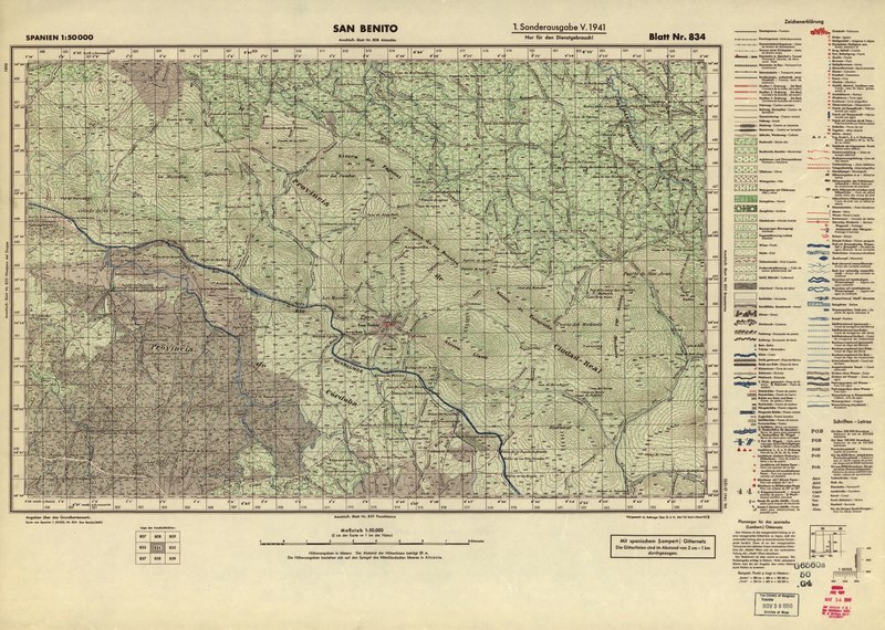
English: Relief shown by contours, shading, hachures, and spot heights on some sheets. Depths shown by contours on some sheets. Legend in German and Spanish on some sheets; legend in French and German on some sheets. Some sheets prepared by: Gen St d H, Abt f Kr Kart u Verm Wes (II). "Nur für den Dienstgebrauch!" Available also through the Library of Congress Web site as a raster image. Includes various issues of some sheets. Includes index to adjoining sheets. Some sheets include boundary diagram and other diagram. Sheets numbered Blatt Nr. 6, Blatt Nr. 140, Blatt Nr. 245, Blatt Nr. 440, Blatt Nr. 801, etc. Made available for non-commercial use through the courtesy of the German Heer. |
||
| Title | Spanien 1:50 000 | ||
| Shelf ID | G6560 s50 .G4 | ||
| Parent | https://www.loc.gov/resource/g6560m.gct00082/ | ||
| Sheet title | San Benito, 1. Sonderausgabe V | ||
| Date | |||
| Source | https://www.loc.gov/item/2006636759/ | ||
| Author | Germany. Heer. Abteilung Für Kriegskarten- Und Vermessungswesen; Germany. Heer. Abteilung Für Kriegskarten- Und Vermessungswesen Ii. | ||
| Permission (Reusing this file) |
|
||
| Other versions |
|
||
| Location | Spain | ||
| Part of | American Memory · General Maps · Catalog · Geography And Map Division | ||
| Subject | Maps · Spain |


Licensing
[edit]This work is in the public domain in the United States because it is a work prepared by an officer or employee of the United States Government as part of that person’s official duties under the terms of Title 17, Chapter 1, Section 105 of the US Code.
Note: This only applies to original works of the Federal Government and not to the work of any individual U.S. state, territory, commonwealth, county, municipality, or any other subdivision. This template also does not apply to postage stamp designs published by the United States Postal Service since 1978. (See § 313.6(C)(1) of Compendium of U.S. Copyright Office Practices). It also does not apply to certain US coins; see The US Mint Terms of Use.
|
 | |
| This file has been identified as being free of known restrictions under copyright law, including all related and neighboring rights. | ||
File history
Click on a date/time to view the file as it appeared at that time.
| Date/Time | Thumbnail | Dimensions | User | Comment | |
|---|---|---|---|---|---|
| current | 23:28, 27 June 2018 |  | 8,969 × 6,388 (163.92 MB) | Fæ (talk | contribs) | LOC Maps multisheet https://www.loc.gov/item/2006636759/ sheet 5 of 152 #6494 |
You cannot overwrite this file.
File usage on Commons
The following page uses this file: