File:Special Map northeast New Guinea. LOC 2013588245-27.tif
Jump to navigation
Jump to search

Size of this JPG preview of this TIF file: 573 × 600 pixels. Other resolutions: 229 × 240 pixels | 459 × 480 pixels | 734 × 768 pixels | 978 × 1,024 pixels | 1,957 × 2,048 pixels | 7,535 × 7,887 pixels.
Original file (7,535 × 7,887 pixels, file size: 170.03 MB, MIME type: image/tiff)
Captions
Captions
Add a one-line explanation of what this file represents
Summary
[edit]| Description |
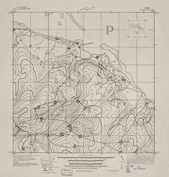
English: Verso of each map contains photomap of corresponding area. "Planimetry compiled from tri-metrogon aerial photography, mission: 267X Sept 1943 by 8th Photo Squadron, 5th Air Force, U.S. Army. Additional information from Anglo Persian Oil Co, Australasian Petroleum Co and local informants." Available also through the Library of Congress Web site as a raster image. |
||
| Title | Special Map northeast New Guinea. | ||
| Shelf ID | G8160 s20 .U5 | ||
| Parent | https://www.loc.gov/resource/g8160m.gct00320/ | ||
| Sheet title | Nom | ||
| Date | |||
| Source | https://www.loc.gov/item/2013588245/ | ||
| Author | United States. Army. Corps Of Engineers; Anglo-Persian Oil Company; Australasian Petroleum Company; United States. Army Air Forces. Photo Reconnaissance Squadron, 8Th. | ||
| Permission (Reusing this file) |
|
||
| Other versions |
|
||
| Location | Papua New Guinea | ||
| Part of | American Memory · General Maps · Catalog · Geography And Map Division | ||
| Subject | Maps · Papua New Guinea |


Licensing
[edit]This work is in the public domain in the United States because it is a work prepared by an officer or employee of the United States Government as part of that person’s official duties under the terms of Title 17, Chapter 1, Section 105 of the US Code.
Note: This only applies to original works of the Federal Government and not to the work of any individual U.S. state, territory, commonwealth, county, municipality, or any other subdivision. This template also does not apply to postage stamp designs published by the United States Postal Service since 1978. (See § 313.6(C)(1) of Compendium of U.S. Copyright Office Practices). It also does not apply to certain US coins; see The US Mint Terms of Use.
|
 | |
| This file has been identified as being free of known restrictions under copyright law, including all related and neighboring rights. | ||
File history
Click on a date/time to view the file as it appeared at that time.
| Date/Time | Thumbnail | Dimensions | User | Comment | |
|---|---|---|---|---|---|
| current | 12:52, 21 May 2018 |  | 7,535 × 7,887 (170.03 MB) | Fæ (talk | contribs) | LOC Maps multisheet https://www.loc.gov/item/2013588245/ sheet 27 of 40 #9114 |
You cannot overwrite this file.
File usage on Commons
The following page uses this file: