File:Spoil train at Magheramorne (geograph 3505762).jpg
Jump to navigation
Jump to search

Size of this preview: 800 × 561 pixels. Other resolutions: 320 × 224 pixels | 640 × 449 pixels | 1,024 × 718 pixels | 1,250 × 876 pixels.
Original file (1,250 × 876 pixels, file size: 838 KB, MIME type: image/jpeg)
Captions
Captions
Add a one-line explanation of what this file represents
Summary
[edit].jpg&action=edit§ion=1)
| Description |
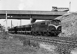
English: Spoil train at Magheramorne In 1974, Northern Ireland Railways was awarded a contract for the haulage of spoil from Magheramorne to the construction site for an oil terminal at Cloghan Point near Kilroot power station. Commencing on 7 October 1974 and using wagons from the steam hauled spoil contract of the late 1960s, these trains were generally in the hands of an NIR 101 class diesel locomotive. The contract ended without ceremony on 22 August 1975. 101 class Bo-Bo No. 102 "Falcon" (now preserved at the Ulster Folk & Transport Museum) pulls out of Magheramorne heading for Cloghan. |
| Date | |
| Source | From geograph.org.uk |
| Author | The Carlisle Kid |
| Permission (Reusing this file) |
Creative Commons Attribution Share-alike license 2.0 |
| Attribution (required by the license) | The Carlisle Kid / Spoil train at Magheramorne / |
| Camera location | | View this and other nearby images on: OpenStreetMap |
|---|
.jpg¶ms=054.812710_N_-005.759297_E_globe:Earth_type:camera_source:geograph-irishgrid(J441984)_heading:315.00&language=en)
| Object location | | View this and other nearby images on: OpenStreetMap |
|---|
.jpg¶ms=054.812710_N_-005.759300_E_globe:Earth_class:object_type:object_source:geograph-irishgrid(J441984)_heading:315.00&language=en)
Licensing
[edit].jpg&action=edit§ion=2)

|
This image was taken from the Geograph project collection. See this photograph's page on the Geograph website for the photographer's contact details. The copyright on this image is owned by The Carlisle Kid and is licensed for reuse under the Creative Commons Attribution-ShareAlike 2.0 license.
|
This file is licensed under the Creative Commons Attribution-Share Alike 2.0 Generic license.
Attribution: The Carlisle Kid
- You are free:
- to share – to copy, distribute and transmit the work
- to remix – to adapt the work
- Under the following conditions:
- attribution – You must give appropriate credit, provide a link to the license, and indicate if changes were made. You may do so in any reasonable manner, but not in any way that suggests the licensor endorses you or your use.
- share alike – If you remix, transform, or build upon the material, you must distribute your contributions under the same or compatible license as the original.
File history
Click on a date/time to view the file as it appeared at that time.
| Date/Time | Thumbnail | Dimensions | User | Comment | |
|---|---|---|---|---|---|
| current | 13:09, 6 March 2022 | | 1,250 × 876 (838 KB) | Lamberhurst (talk | contribs) | == {{int:filedesc}} == {{Information |Description={{en|1=<b>Spoil train at Magheramorne</b><br>In 1974, Northern Ireland Railways was awarded a contract for the haulage of spoil from Magheramorne to the construction site for an oil terminal at Cloghan Point near Kilroot power station. Commencing on 7 October 1974 and using wagons from the steam hauled spoil contract of the late 1960s, these trains were generally in the hands of an NIR 101 class diesel locomotive. The contract ended without ce... |
You cannot overwrite this file.
File usage on Commons
The following page uses this file:
.jpg&oldid=761481645)