File:St. George's Road Board School - geograph.org.uk - 325809.jpg
Jump to navigation
Jump to search
Size of this preview: 462 × 600 pixels. Other resolutions: 185 × 240 pixels | 493 × 640 pixels.
Original file (493 × 640 pixels, file size: 121 KB, MIME type: image/jpeg)
Captions
Captions
Add a one-line explanation of what this file represents
Summary
[edit]
| Description |
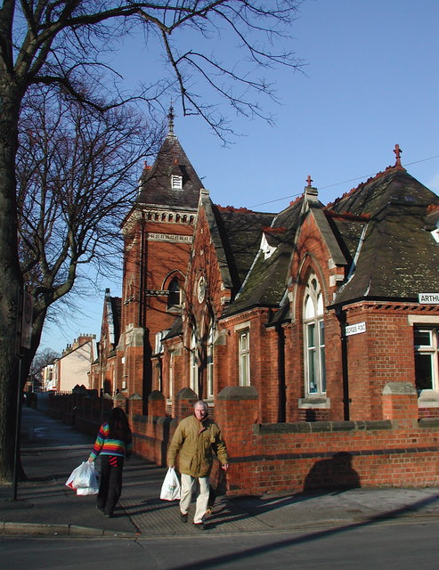
English: St. George's Road Board School The Kingston upon Hull School Board was constituted under the Act in 1871 and built 37 new schools during its short life which ended in 1902. One of a handful of board schools built independently of the Hull School Board was this one: St. George's Road Board School (now St. George's Primary), which was built in 1881 by Newington School Board. I presume it has been threatened with closure as there were 'Save Our School' banners hanging from the building last summer but so far it seems to have escaped the axe. Seen here looking north from the corner of Arthur Street. |
| Date | |
| Source | From geograph.org.uk |
| Author | Paul Glazzard |
| Attribution (required by the license) | Paul Glazzard / St. George's Road Board School / |
| Camera location | | View this and other nearby images on: OpenStreetMap |
|---|
_heading:0.00&language=en)
| Object location | | View this and other nearby images on: OpenStreetMap |
|---|
_heading:0.00&language=en)
Licensing
[edit]

|
This image was taken from the Geograph project collection. See this photograph's page on the Geograph website for the photographer's contact details. The copyright on this image is owned by Paul Glazzard and is licensed for reuse under the Creative Commons Attribution-ShareAlike 2.0 license.
|
This file is licensed under the Creative Commons Attribution-Share Alike 2.0 Generic license.
Attribution: Paul Glazzard
- You are free:
- to share – to copy, distribute and transmit the work
- to remix – to adapt the work
- Under the following conditions:
- attribution – You must give appropriate credit, provide a link to the license, and indicate if changes were made. You may do so in any reasonable manner, but not in any way that suggests the licensor endorses you or your use.
- share alike – If you remix, transform, or build upon the material, you must distribute your contributions under the same or compatible license as the original.
- Remove redundant categories and try to put this image in the most specific category/categories
- Remove this template
- The location categories are based on information from this geonames tool and this OpenStreetMap tool combined with a database. You can also have a look at this tool from mysociety.
- The topic category from Geograph was Board school (find similar images school at Geograph)
File history
Click on a date/time to view the file as it appeared at that time.
| Date/Time | Thumbnail | Dimensions | User | Comment | |
|---|---|---|---|---|---|
| current | 19:24, 30 December 2010 | | 493 × 640 (121 KB) | GeographBot (talk | contribs) | == {{int:filedesc}} == {{Information |description={{en|1=St. George's Road Board School The Kingston upon Hull School Board was constituted under the Act in 1871 and built 37 new schools during its short life which ended in 1902. One of a handful of board |
You cannot overwrite this file.
File usage on Commons
There are no pages that use this file.