File:St. Mary's church, Woolpit, Suffolk - geograph.org.uk - 237111.jpg
Jump to navigation
Jump to search

Size of this preview: 450 × 600 pixels. Other resolutions: 180 × 240 pixels | 480 × 640 pixels.
Original file (480 × 640 pixels, file size: 60 KB, MIME type: image/jpeg)
Captions
Captions
Add a one-line explanation of what this file represents
Summary
[edit]
| Description |
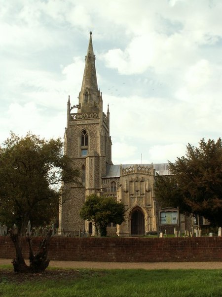
English: St. Mary's church, Woolpit, Suffolk. This is one of most attractive Suffolk churches, though its spire is more like a church from the fens. The tower and spire were only built in 1854 by R. M. Phipson, but the rest of the church dates from the 14th and 15th centuries. It has a magnificent south porch, which is due to money being given towards its construction in 1430 and 1452. Inside there is one of the most impressive double hammerbeam roofs in Suffolk. |
| Date | |
| Source | From geograph.org.uk |
| Author | Robert Edwards |
| Attribution (required by the license) | Robert Edwards / St. Mary's church, Woolpit, Suffolk / |
| Camera location | | View this and other nearby images on: OpenStreetMap |
|---|
_heading:0.00&language=en)
| Object location | | View this and other nearby images on: OpenStreetMap |
|---|
_heading:0.00&language=en)
Licensing
[edit]

|
This image was taken from the Geograph project collection. See this photograph's page on the Geograph website for the photographer's contact details. The copyright on this image is owned by Robert Edwards and is licensed for reuse under the Creative Commons Attribution-ShareAlike 2.0 license.
|
This file is licensed under the Creative Commons Attribution-Share Alike 2.0 Generic license.
Attribution: Robert Edwards
- You are free:
- to share – to copy, distribute and transmit the work
- to remix – to adapt the work
- Under the following conditions:
- attribution – You must give appropriate credit, provide a link to the license, and indicate if changes were made. You may do so in any reasonable manner, but not in any way that suggests the licensor endorses you or your use.
- share alike – If you remix, transform, or build upon the material, you must distribute your contributions under the same or compatible license as the original.
File history
Click on a date/time to view the file as it appeared at that time.
| Date/Time | Thumbnail | Dimensions | User | Comment | |
|---|---|---|---|---|---|
| current | 02:18, 1 February 2010 | | 480 × 640 (60 KB) | GeographBot (talk | contribs) | == {{int:filedesc}} == {{Information |description={{en|1=St. Mary's church, Woolpit, Suffolk. This is one of most attractive Suffolk churches, though its spire is more like a church from the fens. The tower and spire were only built in 1854 by R. M. Phips |
You cannot overwrite this file.
File usage on Commons
There are no pages that use this file.
File usage on other wikis
The following other wikis use this file:
- Usage on en.wikipedia.org
- Usage on it.wikipedia.org