File:St Botolph's church, Knottingley- south side and tower (geograph 7255632).jpg
Jump to navigation
Jump to search
Size of this preview: 800 × 600 pixels. Other resolutions: 320 × 240 pixels | 640 × 480 pixels | 1,024 × 768 pixels | 1,280 × 960 pixels | 1,600 × 1,200 pixels.
Original file (1,600 × 1,200 pixels, file size: 414 KB, MIME type: image/jpeg)
Captions
Captions
Add a one-line explanation of what this file represents
Summary
[edit].jpg&action=edit§ion=1)
| Description |
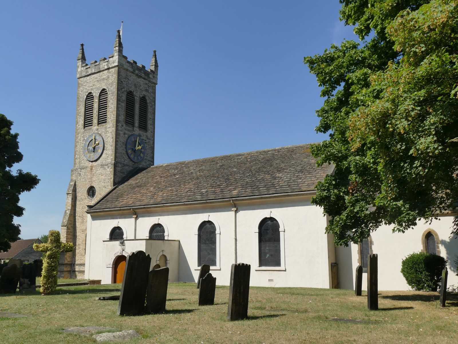
English: There has been a church here since Norman times (if not earlier), built by Henry de Lacy, Lord of the manor, as chapel of ease to All Saints, Pontefract.
The present church dates from c.1750, initially without a tower. The tower was built in the 1830s after the fashion of that time. It was heightened in 1887 to mark the Golden Jubilee of Queen Victoria along with the rebuilding of the Chancel and removal of the galleries. It had 'tubular' bells initially, but in 1995 these were replaced with a ring of ten conventional bells in memory of Revd Edward Beaumont, Vicar of Knottingley 1954 - 1970 (sources: parish website and HE listing, grade II, entry 1225755). |
| Date | |
| Source | From geograph.org.uk |
| Author | Stephen Craven |
| Permission (Reusing this file) |
Creative Commons Attribution Share-alike license 2.0 |
| Attribution (required by the license) | Stephen Craven / St Botolph's church, Knottingley: south side and tower / |
| Camera location | | View this and other nearby images on: OpenStreetMap |
|---|
.jpg¶ms=053.710575_N_-001.243957_E_globe:Earth_type:camera_source:geograph-osgb36(SE50002406)_heading:315.00&language=en)
| Object location | | View this and other nearby images on: OpenStreetMap |
|---|
.jpg¶ms=053.710850_N_-001.244410_E_globe:Earth_class:object_type:object_source:geograph-osgb36(SE49972409)_heading:315.00&language=en)
Licensing
[edit].jpg&action=edit§ion=2)

|
This image was taken from the Geograph project collection. See this photograph's page on the Geograph website for the photographer's contact details. The copyright on this image is owned by Stephen Craven and is licensed for reuse under the Creative Commons Attribution-ShareAlike 2.0 license.
|
This file is licensed under the Creative Commons Attribution-Share Alike 2.0 Generic license.
Attribution: Stephen Craven
- You are free:
- to share – to copy, distribute and transmit the work
- to remix – to adapt the work
- Under the following conditions:
- attribution – You must give appropriate credit, provide a link to the license, and indicate if changes were made. You may do so in any reasonable manner, but not in any way that suggests the licensor endorses you or your use.
- share alike – If you remix, transform, or build upon the material, you must distribute your contributions under the same or compatible license as the original.
File history
Click on a date/time to view the file as it appeared at that time.
| Date/Time | Thumbnail | Dimensions | User | Comment | |
|---|---|---|---|---|---|
| current | 18:45, 23 November 2022 | | 1,600 × 1,200 (414 KB) | Chocolateediter (talk | contribs) | == {{int:filedesc}} == {{Information |Description={{en|1= There has been a church here since Norman times (if not earlier), built by Henry de Lacy, Lord of the manor, as chapel of ease to All Saints, Pontefract. The present church dates from c.1750, initially without a tower. The tower was built in the 1830s after the fashion of that time. It was heightened in 1887 to mark the Golden Jubilee of Queen Victoria along with the rebuilding of the Chancel and removal of the galleries. It had 'tubu... |
You cannot overwrite this file.
File usage on Commons
There are no pages that use this file.
File usage on other wikis
The following other wikis use this file:
- Usage on en.wikipedia.org
.jpg&oldid=787909495)