File:St Catherine's Lighthouse - geograph.org.uk - 1414472.jpg
Jump to navigation
Jump to search
Size of this preview: 450 × 600 pixels. Other resolutions: 180 × 240 pixels | 480 × 640 pixels.
Original file (480 × 640 pixels, file size: 40 KB, MIME type: image/jpeg)
Captions
Captions
Add a one-line explanation of what this file represents
Summary
[edit]
| Description |
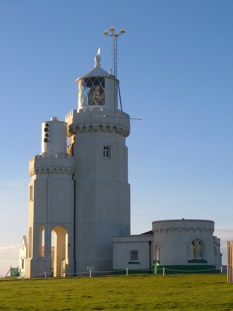
English: St Catherine's Lighthouse Like most lighthouses, it's an attractive structure, also shown at https://www.geograph.org.uk/gridref/SZ4975?class=Lighthouse&nl=1 . "Built 1838-40. Designed by Walker and Burgess and altered in 1875 when, on account of mist the height was reduced to 86 feet by the removal of the upper stage and part of the middle stage. Stuccoed octagonal tower of 2 stages. Machicolations and castellated parapet surmounted by conical light and ball finial and weathervane. In 1932 a lower tower of 2 storeys, reproducing the design of the main lighthouse as shortened, but with an open arcade on the ground floor, was added on the south side to mount the foghorn. These 2 towers are known locally as the Cow and the Calf. To the west of the main Lighthouse tower is a doorway with the date 1838 over it and a projection on the ground floor with gable above {this can be seen on the left}. Attached to the east is the Head Lighthouse keeper's house of 1 storey with curved front and round headed window facing east. This lighthouse was one of the first in the world to be illuminated by electric light being fitted with it in 1888 ... St Catherine's lighthouse was built as a result of the wreck of the 'Clarendon' in Chale Bay on the 11th October 1836. " http://www.imagesofengland.org.uk/details/default.aspx?id=392863 |
| Date | |
| Source | From geograph.org.uk |
| Author | Derek Harper |
| Attribution (required by the license) | Derek Harper / St Catherine's Lighthouse / |
| Camera location | | View this and other nearby images on: OpenStreetMap |
|---|
_heading:270.00&language=en)
| Object location | | View this and other nearby images on: OpenStreetMap |
|---|
_heading:270.00&language=en)
Licensing
[edit]

|
This image was taken from the Geograph project collection. See this photograph's page on the Geograph website for the photographer's contact details. The copyright on this image is owned by Derek Harper and is licensed for reuse under the Creative Commons Attribution-ShareAlike 2.0 license.
|
This file is licensed under the Creative Commons Attribution-Share Alike 2.0 Generic license.
Attribution: Derek Harper
- You are free:
- to share – to copy, distribute and transmit the work
- to remix – to adapt the work
- Under the following conditions:
- attribution – You must give appropriate credit, provide a link to the license, and indicate if changes were made. You may do so in any reasonable manner, but not in any way that suggests the licensor endorses you or your use.
- share alike – If you remix, transform, or build upon the material, you must distribute your contributions under the same or compatible license as the original.
File history
Click on a date/time to view the file as it appeared at that time.
| Date/Time | Thumbnail | Dimensions | User | Comment | |
|---|---|---|---|---|---|
| current | 17:01, 1 March 2011 | | 480 × 640 (40 KB) | GeographBot (talk | contribs) | == {{int:filedesc}} == {{Information |description={{en|1=St Catherine's Lighthouse Like most lighthouses, it's an attractive structure, also shown at http://www.geograph.org.uk/gridref/SZ4975?class=Lighthouse&nl=1 . "Built 1838-40. Designed by Walker and |
You cannot overwrite this file.
File usage on Commons
There are no pages that use this file.
File usage on other wikis
The following other wikis use this file:
- Usage on fr.wikipedia.org
- Usage on nl.wikipedia.org