File:St Helen's church - rood screen detail - geograph.org.uk - 725155.jpg
Jump to navigation
Jump to search
Size of this preview: 450 × 600 pixels. Other resolutions: 180 × 240 pixels | 480 × 640 pixels.
Original file (480 × 640 pixels, file size: 186 KB, MIME type: image/jpeg)
Captions
Captions
Add a one-line explanation of what this file represents
Summary
[edit]
| Description |
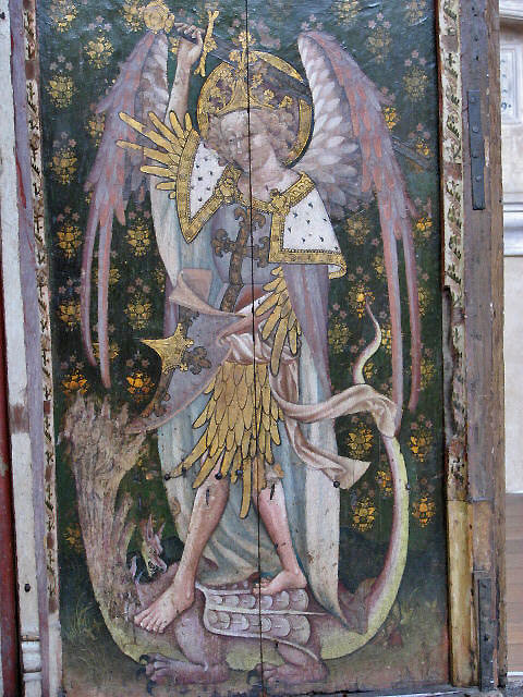
English: St Helen's church - rood screen detail. Ranworth is a busy Broadland village adjacent to Malthouse and Ranworth Broads. St Helen's church dates back to 1370 and is known as the Cathedral of the Broads. The church is known for several of its features: just inside the south door there is the so-called Ranworth Antiphoner, a large illuminated manuscript containing text and music of psalms that were said and sung alternately between priest and choir; the book consists of 285 vellum pages illuminated with colour and gold leaf and was produced by monks at Langley Abbey in the 15th century > 84764. The Antiphoner is displayed behind bullet-proof glass. A Cantor's desk, used for reading the Gospel, is decorated with an image of St. John's evagelistic symbol on one side and a 15th century versicle from of the Gloria has been pasted onto the other, traces of which can still clearly be seen > 725156. The rood screen is one of the best in East Anglia > 311177. It stretches across the church, including aisles and nave and forms reredoses to the aisle chapels > 725150 - 725152. Paintings of St Michael (seen here) and St George > 725153, both depicted killing a dragon, face each other on the parclose screen. With Ranworth being a busy holiday destination, St Helen has many visitors, who are being catered for in the adjacent tea room. The church is open every day. For more information see: http://www.norfolkchurches.co.uk/ranworth/ranworth.htm |
| Date | |
| Source | From geograph.org.uk |
| Author | Evelyn Simak |
| Attribution (required by the license) | Evelyn Simak / St Helen's church - rood screen detail / |
| Camera location | | View this and other nearby images on: OpenStreetMap |
|---|
_heading:112.00&language=en)
| Object location | | View this and other nearby images on: OpenStreetMap |
|---|
_heading:112.00&language=en)
Licensing
[edit]

|
This image was taken from the Geograph project collection. See this photograph's page on the Geograph website for the photographer's contact details. The copyright on this image is owned by Evelyn Simak and is licensed for reuse under the Creative Commons Attribution-ShareAlike 2.0 license.
|
This file is licensed under the Creative Commons Attribution-Share Alike 2.0 Generic license.
Attribution: Evelyn Simak
- You are free:
- to share – to copy, distribute and transmit the work
- to remix – to adapt the work
- Under the following conditions:
- attribution – You must give appropriate credit, provide a link to the license, and indicate if changes were made. You may do so in any reasonable manner, but not in any way that suggests the licensor endorses you or your use.
- share alike – If you remix, transform, or build upon the material, you must distribute your contributions under the same or compatible license as the original.
File history
Click on a date/time to view the file as it appeared at that time.
| Date/Time | Thumbnail | Dimensions | User | Comment | |
|---|---|---|---|---|---|
| current | 05:46, 19 February 2011 | | 480 × 640 (186 KB) | GeographBot (talk | contribs) | == {{int:filedesc}} == {{Information |description={{en|1=St Helen's church - rood screen detail Ranworth is a busy Broadland village adjacent to Malthouse and Ranworth Broads. St Helen's church dates back to 1370 and is known as the Cathedral of the Broa |
You cannot overwrite this file.
File usage on Commons
There are no pages that use this file.
File usage on other wikis
The following other wikis use this file:
- Usage on de.wikipedia.org