File:St Mary, Iwerne Courtney- memorial (XI) (geograph 3192730).jpg
Jump to navigation
Jump to search

Size of this preview: 450 × 600 pixels. Other resolutions: 180 × 240 pixels | 480 × 640 pixels.
Original file (480 × 640 pixels, file size: 57 KB, MIME type: image/jpeg)
Captions
Captions
Add a one-line explanation of what this file represents
Summary
[edit]_(geograph_3192730).jpg&action=edit§ion=1)
| Description |
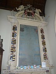
English: St Mary, Iwerne Courtney: memorial to Sir Thomas Freke (1563-1633) and his wife Elizabeth Taylor daughter of John Taylor of Burton Bradstock. This has open segmental pediment, sculptured pediment and carved putti, angels, doves etc.[1]. Dominates the confines of the north aisle chapel where it was erected by his two sons Raufe and William in 1654. Pevsner describes the carving of the figures as 'inept if lovable'.[2]. Left column, top shield, arms of Freke impaling Trenchard |
| Date | |
| Source | From geograph.org.uk |
| Author | Basher Eyre |
| Permission (Reusing this file) |
Creative Commons Attribution Share-alike license 2.0 |
| Attribution (required by the license) | Basher Eyre / St Mary, Iwerne Courtney: memorial (XI) / |
| Camera location | | View this and other nearby images on: OpenStreetMap |
|---|
_(geograph_3192730).jpg¶ms=050.911344_N_-002.200787_E_globe:Earth_type:camera_heading:157.00&language=en)
Licensing
[edit]_(geograph_3192730).jpg&action=edit§ion=2)

|
This image was taken from the Geograph project collection. See this photograph's page on the Geograph website for the photographer's contact details. The copyright on this image is owned by Basher Eyre and is licensed for reuse under the Creative Commons Attribution-ShareAlike 2.0 license.
|
This file is licensed under the Creative Commons Attribution-Share Alike 2.0 Generic license.
Attribution: Basher Eyre
- You are free:
- to share – to copy, distribute and transmit the work
- to remix – to adapt the work
- Under the following conditions:
- attribution – You must give appropriate credit, provide a link to the license, and indicate if changes were made. You may do so in any reasonable manner, but not in any way that suggests the licensor endorses you or your use.
- share alike – If you remix, transform, or build upon the material, you must distribute your contributions under the same or compatible license as the original.
File history
Click on a date/time to view the file as it appeared at that time.
| Date/Time | Thumbnail | Dimensions | User | Comment | |
|---|---|---|---|---|---|
| current | 09:53, 22 September 2015 | | 480 × 640 (57 KB) | WereSpielChequers (talk | contribs) | Transferred from geograph.co.uk using [https://tools.wmflabs.org/geograph2commons/ grograph2commons] |
You cannot overwrite this file.
File usage on Commons
There are no pages that use this file.
File usage on other wikis
The following other wikis use this file:
- Usage on en.wikipedia.org
_(geograph_3192730).jpg&oldid=394905713)