File:St Peters Church, Pentre, Rhondda Fawr Valley, South Wales - geograph.org.uk - 1248615.jpg
Jump to navigation
Jump to search

Size of this preview: 495 × 599 pixels. Other resolutions: 198 × 240 pixels | 529 × 640 pixels.
Original file (529 × 640 pixels, file size: 144 KB, MIME type: image/jpeg)
Captions
Captions
Add a one-line explanation of what this file represents
Summary
[edit]
| Description |
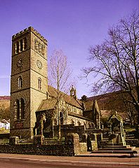
English: St Peters Church, Pentre, Rhondda Fawr Valley, South Wales Built in 1890 at the height of the coal boom time in the Rhondda Valley.
St Peter's has a magnificent peal of 8 bells with the tenor a heavy 1,366kg. The tower is over 100ft high. |
| Date | |
| Source | From geograph.org.uk |
| Author | Peter Brabham |
| Attribution (required by the license) | Peter Brabham / St Peters Church, Pentre, Rhondda Fawr Valley, South Wales / |
| Camera location | | View this and other nearby images on: OpenStreetMap |
|---|
_heading:337.00&language=en)
| Object location | | View this and other nearby images on: OpenStreetMap |
|---|
_heading:337.00&language=en)
Licensing
[edit]

|
This image was taken from the Geograph project collection. See this photograph's page on the Geograph website for the photographer's contact details. The copyright on this image is owned by Peter Brabham and is licensed for reuse under the Creative Commons Attribution-ShareAlike 2.0 license.
|
This file is licensed under the Creative Commons Attribution-Share Alike 2.0 Generic license.
Attribution: Peter Brabham
- You are free:
- to share – to copy, distribute and transmit the work
- to remix – to adapt the work
- Under the following conditions:
- attribution – You must give appropriate credit, provide a link to the license, and indicate if changes were made. You may do so in any reasonable manner, but not in any way that suggests the licensor endorses you or your use.
- share alike – If you remix, transform, or build upon the material, you must distribute your contributions under the same or compatible license as the original.
| Annotations | This image is annotated: View the annotations at Commons |
File history
Click on a date/time to view the file as it appeared at that time.
| Date/Time | Thumbnail | Dimensions | User | Comment | |
|---|---|---|---|---|---|
| current | 17:46, 26 February 2011 | | 529 × 640 (144 KB) | GeographBot (talk | contribs) | == {{int:filedesc}} == {{Information |description={{en|1=St Peters Church, Pentre, Rhondda Fawr Valley, South Wales Built in 1890 at the height of the coal boom time in the Rhondda Valley. St Peter's has a magnificent peal of 8 bells with the tenor a hea |
You cannot overwrite this file.
File usage on Commons
The following 2 pages use this file:
File usage on other wikis
The following other wikis use this file:
- Usage on cy.wikipedia.org
- Usage on de.wikipedia.org
- Usage on en.wikipedia.org
- Usage on eu.wikipedia.org
- Usage on fr.wikipedia.org
- Usage on ga.wikipedia.org
- Usage on gd.wikipedia.org
- Usage on it.wikipedia.org
- Usage on kw.wikipedia.org
- Usage on sv.wikipedia.org
- Usage on www.wikidata.org
- Usage on zh-min-nan.wikipedia.org