File:State of Sequoyah LOC 2013592417.tif
Jump to navigation
Jump to search

Size of this JPG preview of this TIF file: 540 × 599 pixels. Other resolutions: 216 × 240 pixels | 433 × 480 pixels | 692 × 768 pixels | 923 × 1,024 pixels | 1,847 × 2,048 pixels | 4,749 × 5,267 pixels.
Original file (4,749 × 5,267 pixels, file size: 71.56 MB, MIME type: image/tiff)
Captions
Captions
Add a one-line explanation of what this file represents
Summary[edit]
| Description |
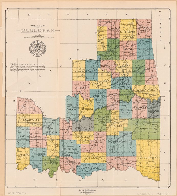
English: Shows names of land owners and railroads. Covers part of eastern Oklahoma. "Map of Indian territory, edition of July 1902, revised to date, and county divisions made under direction of Sequoyah Statehood Convention, August and September 1905; by D.W. Bolich, Civil Engineer, Muskogee, Ind. Ter." Available also through the Library of Congress Web site as a raster image. Acquisitions control no.: 99-6 AACR2 |
||
| Title | State of Sequoyah | ||
| Shelf ID | G4021.G46 1905 .G4 | ||
| Date | |||
| Source | https://www.loc.gov/item/2013592417/ | ||
| Author | Geological Survey (U.S.) | ||
| Permission (Reusing this file) |
|
||
| Other versions |
|
||
| Location | United States · Oklahoma. · Oklahoma | ||
| Part of | American Memory · General Maps · Catalog · Geography And Map Division | ||
| Subject | Cadastral Maps · Oklahoma · Railroads · United States · Maps · Landowners |


Licensing[edit]
|
This is a faithful photographic reproduction of a two-dimensional, public domain work of art. The work of art itself is in the public domain for the following reason:
The official position taken by the Wikimedia Foundation is that "faithful reproductions of two-dimensional public domain works of art are public domain".
This photographic reproduction is therefore also considered to be in the public domain in the United States. In other jurisdictions, re-use of this content may be restricted; see Reuse of PD-Art photographs for details. | ||||
File history
Click on a date/time to view the file as it appeared at that time.
| Date/Time | Thumbnail | Dimensions | User | Comment | |
|---|---|---|---|---|---|
| current | 14:39, 12 June 2019 |  | 4,749 × 5,267 (71.56 MB) | Fæ (talk | contribs) | LOC Maps https://www.loc.gov/item/2013592417/ #1280 |
You cannot overwrite this file.
File usage on Commons
The following page uses this file: