File:Steam train crossing Penrhyn Corner level crossing, Fairbourne.jpg
Jump to navigation
Jump to search

Size of this preview: 800 × 600 pixels. Other resolutions: 320 × 240 pixels | 640 × 480 pixels | 1,024 × 768 pixels.
Original file (1,024 × 768 pixels, file size: 128 KB, MIME type: image/jpeg)
Captions
Captions
Add a one-line explanation of what this file represents
Summary
[edit]
| Description |
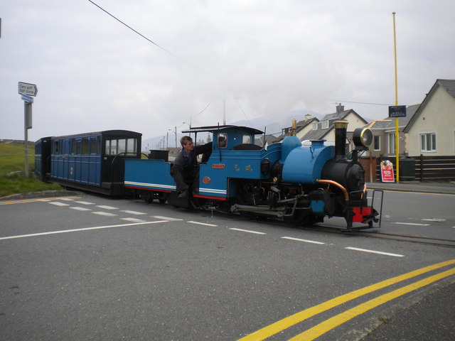
English: Train crossing Penrhyn Corner level crossing, Fairbourne. A train from Penrhyn Point crosses SH6113 : Penrhyn Corner level crossing, Fairbourne on the 12¼" gauge Fairbourne Railway, hauled by the steam locomotive "Sherpa", a half size replica of a Darjeeling Himalayan Railway B class locomotive. |
| Date | |
| Source | [1] and *.jpg |
| Author | © Copyright Richard Vince |
| Permission (Reusing this file) |
Licensed for reuse under Attribution-ShareAlike 2.0 Generic Creative Commons Licence (CC BY-SA 2.0) |
| Attribution (required by the license) | Richard Vince / Train crossing Penrhyn Corner level crossing, Fairbourne / |
| Camera location | | View this and other nearby images on: OpenStreetMap |
|---|
_heading:337.00&language=en)
| Object location | | View this and other nearby images on: OpenStreetMap |
|---|
_heading:337.00&language=en)
Licensing
[edit]

|
This image was taken from the Geograph project collection. See this photograph's page on the Geograph website for the photographer's contact details. The copyright on this image is owned by Richard Vince and is licensed for reuse under the Creative Commons Attribution-ShareAlike 2.0 license.
|
This file is licensed under the Creative Commons Attribution-Share Alike 2.0 Generic license.
Attribution: Richard Vince
- You are free:
- to share – to copy, distribute and transmit the work
- to remix – to adapt the work
- Under the following conditions:
- attribution – You must give appropriate credit, provide a link to the license, and indicate if changes were made. You may do so in any reasonable manner, but not in any way that suggests the licensor endorses you or your use.
- share alike – If you remix, transform, or build upon the material, you must distribute your contributions under the same or compatible license as the original.
File history
Click on a date/time to view the file as it appeared at that time.
| Date/Time | Thumbnail | Dimensions | User | Comment | |
|---|---|---|---|---|---|
| current | 21:48, 20 September 2017 | | 1,024 × 768 (128 KB) | Geograph Update Bot (talk | contribs) | Higher-resolution version from Geograph. |
| 22:52, 7 March 2016 |  | 640 × 480 (55 KB) | NearEMPTiness (talk | contribs) | Transferred from http://s0.geograph.org.uk/geophotos/04/72/68/4726896_57a42eea.jpg |
You cannot overwrite this file.
File usage on Commons
The following 3 pages use this file:
File usage on other wikis
The following other wikis use this file:
- Usage on cy.wikipedia.org