File:Stein an der Donau - ehemalige Minoritenkirche.JPG
Jump to navigation
Jump to search

Size of this preview: 649 × 600 pixels. Other resolutions: 260 × 240 pixels | 520 × 480 pixels | 831 × 768 pixels | 1,108 × 1,024 pixels | 2,217 × 2,048 pixels | 3,578 × 3,306 pixels.
Original file (3,578 × 3,306 pixels, file size: 9.55 MB, MIME type: image/jpeg)
Captions
Captions
Add a one-line explanation of what this file represents
Summary[edit]
| Description |
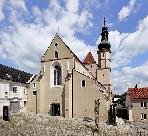
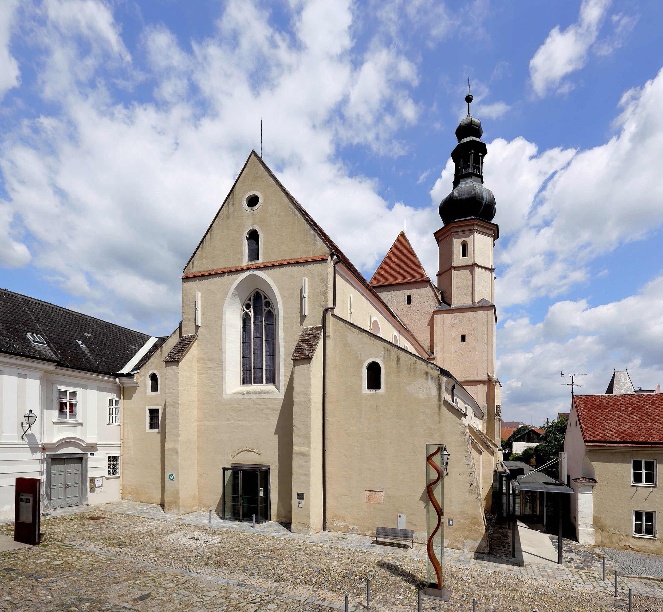
Deutsch: Südwestansicht der ehemaligen Minoritenkirche in Stein an der Donau, ein Stadtteil der niederösterreichischen Stadt Krems.
Nachdem um 1223/24 die Minoriten in Stein ein Kloster gründeten, erfolgte 1264 die Kirchenweihe. Die spätromanische bzw. frühgotische dreischiffige Basilika hat einen höheren, einschiffigen gotischen Langchor, der vermutlich um 1330 gebaut wurde, und einen Südturm mit barocker Bekrönung, der um 1444 errichtet wurde. Zur Reformationszeit wurde der Kirchenbau bis 1577 als Salzdepot genutzt und 1592 erfolgte die Rückgabe an die Minoriten. Mit der Aufhebung des Klosters im Jahre 1790/96 wurde auch die Kirche profaniert und anschließend unter anderem als Tabakmagazin und Feuerwehrdepot verwendet. 1950/51 wurde die Kirche saniert und ab 1992 von der Kunsthalle Krems genutzt. Im Jahr 2002 erfolgte die Übernahme des Kirchenraumes durch die NÖ Festival und Kino GmbH und es fand anschließend bis 2004 eine neuerliche umfassende Renovierung durch den Architekten Fritz Göbl statt. Unter anderem wurde dabei auch südseitig ein neuer Zugangsfoyer errichtet. Die Kirche wird nun als „Klangraum Krems“ vermarktet. |
| Date | |
| Source | Own work |
| Author | C.Stadler/Bwag |
| Permission (Reusing this file) |
Deutsch: Hallo, du darfst mein Foto kostenlos nutzen, aber nenne mich bitte als Fotograf, beispielsweise „Foto: C.Stadler/Bwag“ oder © C.Stadler/Bwag; CC-BY-SA-4.0. Auf mehr Angaben bestehe ich nicht - im Gegensatz zu manch anderen, die die Vorgaben der unten angeführten Lizenzierung auf Punkt und Beistrich einfordern. English: Feel free to use my photos, but please mention me as the author like © C.Stadler/Bwag or © C.Stadler/Bwag; CC-BY-SA-4.0 (that's good enough) and if you want send me a message: bwag@gmx.net. |
| Camera location | | View this and other nearby images on: OpenStreetMap |
|---|
| Object location | | View this and other nearby images on: OpenStreetMap |
|---|
Licensing[edit]
I, the copyright holder of this work, hereby publish it under the following license:
This file is licensed under the Creative Commons Attribution-Share Alike 4.0 International license.
- You are free:
- to share – to copy, distribute and transmit the work
- to remix – to adapt the work
- Under the following conditions:
- attribution – You must give appropriate credit, provide a link to the license, and indicate if changes were made. You may do so in any reasonable manner, but not in any way that suggests the licensor endorses you or your use.
- share alike – If you remix, transform, or build upon the material, you must distribute your contributions under the same or compatible license as the original.
File history
Click on a date/time to view the file as it appeared at that time.
| Date/Time | Thumbnail | Dimensions | User | Comment | |
|---|---|---|---|---|---|
| current | 15:58, 18 August 2016 | | 3,578 × 3,306 (9.55 MB) | Bwag (talk | contribs) | {{Information |Description= {{de|1= Südwestansicht der ehemaligen Minoritenkirche in Stein an der Donau, ein Ortsteil der niederösterreichischen Stadt Krems.<br/>Nachdem um 1223/24 die Minoriten... |
You cannot overwrite this file.
File usage on Commons
The following page uses this file:
File usage on other wikis
The following other wikis use this file:
- Usage on de.wikipedia.org
- Usage on ru.wikivoyage.org
- Usage on www.wikidata.org
- Usage on zh.wikipedia.org