File:Steyr Mesnerhaus Brucknerstiege.jpg
Jump to navigation
Jump to search

Size of this preview: 800 × 533 pixels. Other resolutions: 320 × 213 pixels | 640 × 427 pixels | 1,024 × 683 pixels | 1,280 × 853 pixels | 2,560 × 1,707 pixels | 8,977 × 5,985 pixels.
Original file (8,977 × 5,985 pixels, file size: 22.51 MB, MIME type: image/jpeg)
Captions
Captions
Add a one-line explanation of what this file represents
Summary[edit]
| Description |
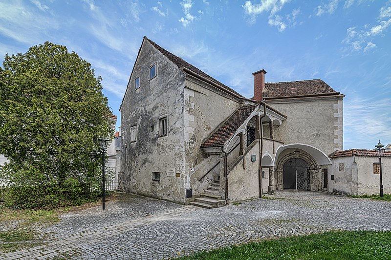
Deutsch: Das Mesnerhaus mit der sogenannten Brucknerstiege wurde im 16. Jahrhundert erbaut. Die Brucknerstiege war damals der Haupteingang zum Kirchenareal. English: The sacristan's house with the so-called Bruckner stair was built in the 16th century. Back then, the Bruckner stair was the main entrance to the church area.
|
| Date | |
| Source | Own work |
| Author | Isiwal |
| Camera location | | View this and other nearby images on: OpenStreetMap |
|---|

|
NOTE: This image is a panorama of Steyr Mesnerhaus Brucknerstiege consisting of 6 frames that were merged or stitched in Photoshop CC Ver. 22.5.2. As a result, this image necessarily underwent some form of digital manipulation. These manipulations may include blending, blurring, cloning, and colour and perspective adjustments. As a result of these adjustments, the image content may be slightly different from reality at the points where multiple images were combined. This manipulation is often required due to lens, perspective, and parallax distortions.
|
Licensing[edit]
I, the copyright holder of this work, hereby publish it under the following license:
This file is licensed under the Creative Commons Attribution-Share Alike 4.0 International license.
- You are free:
- to share – to copy, distribute and transmit the work
- to remix – to adapt the work
- Under the following conditions:
- attribution – You must give appropriate credit, provide a link to the license, and indicate if changes were made. You may do so in any reasonable manner, but not in any way that suggests the licensor endorses you or your use.
- share alike – If you remix, transform, or build upon the material, you must distribute your contributions under the same or compatible license as the original.

|
Diese Datei wurde im Rahmen von WikiDaheim 2021 in Österreich erstellt und hochgeladen. Sie wurde dem Themenbereich Denkmalschutz zugeordnet. |
This image has been assessed using the Quality image guidelines and is considered a Quality image.
|
File history
Click on a date/time to view the file as it appeared at that time.
| Date/Time | Thumbnail | Dimensions | User | Comment | |
|---|---|---|---|---|---|
| current | 16:51, 26 July 2021 | | 8,977 × 5,985 (22.51 MB) | Isiwal (talk | contribs) | Uploaded own work with UploadWizard |
You cannot overwrite this file.
File usage on Commons
The following 3 pages use this file: