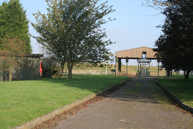
File:Stonesby PSD (petroleum storage depot) - geograph.org.uk - 594114.jpg
Stonesby_PSD_(petroleum_storage_depot)_-_geograph.org.uk_-_594114.jpg (640 × 427 pixels, file size: 113 KB, MIME type: image/jpeg)
Captions
Captions
Summary[edit]
| DescriptionStonesby PSD (petroleum storage depot) - geograph.org.uk - 594114.jpg |
English: Stonesby PSD (petroleum storage depot), near to Stonesby, Leicestershire, Great Britain.
This PSD is shared with Arqiva although the sign on the gate still said it was an NTL site. Arqiva, formerly the broadcast division of NTL Group and now operating independently, has been a leader in the transmission industry for over 50 years. Over 22 million UK homes receive ITV, Channel 4 and five via Arqiva�s national transmitter networks and there is a telecommunications mast in the north east corner of the site, clearly visible on Google Earth. There are also several workshops on the west of the site, with old NTL signage. The telecommunications mast has since been removed. |
| Date | |
| Source | From geograph.org.uk; transferred by User:Adambro using geograph_org2commons. |
| Author | Kate Jewell |
| Permission (Reusing this file) |
Creative Commons Attribution Share-alike license 2.0 |
| Attribution (required by the license) InfoField | Kate Jewell / Stonesby PSD (petroleum storage depot) / |
InfoField | Kate Jewell / Stonesby PSD (petroleum storage depot) |
| Camera location | 52° 48′ 59.72″ N, 0° 47′ 38.17″ W | View this and other nearby images on: OpenStreetMap |
|---|
| Object location | 52° 49′ 01″ N, 0° 47′ 34″ W | View this and other nearby images on: OpenStreetMap |
|---|
Licensing[edit]

|
This image was taken from the Geograph project collection. See this photograph's page on the Geograph website for the photographer's contact details. The copyright on this image is owned by Kate Jewell and is licensed for reuse under the Creative Commons Attribution-ShareAlike 2.0 license.
|
- You are free:
- to share – to copy, distribute and transmit the work
- to remix – to adapt the work
- Under the following conditions:
- attribution – You must give appropriate credit, provide a link to the license, and indicate if changes were made. You may do so in any reasonable manner, but not in any way that suggests the licensor endorses you or your use.
- share alike – If you remix, transform, or build upon the material, you must distribute your contributions under the same or compatible license as the original.
File history
Click on a date/time to view the file as it appeared at that time.
| Date/Time | Thumbnail | Dimensions | User | Comment | |
|---|---|---|---|---|---|
| current | 09:42, 5 June 2010 |  | 640 × 427 (113 KB) | File Upload Bot (Magnus Manske) (talk | contribs) | == {{int:filedesc}} == {{Information |Description={{en|1=Stonesby PSD (petroleum storage depot), near to Stonesby, Leicestershire, Great Britain. This PSD is shared with Arqiva although the sign on the gate still said it was an NTL site. Arqiva, formerly |
| 09:42, 5 June 2010 |  | 640 × 427 (113 KB) | File Upload Bot (Magnus Manske) (talk | contribs) | == {{int:filedesc}} == {{Information |Description={{en|1=Stonesby PSD (petroleum storage depot), near to Stonesby, Leicestershire, Great Britain. This PSD is shared with Arqiva although the sign on the gate still said it was an NTL site. Arqiva, formerly |
You cannot overwrite this file.
File usage on Commons
There are no pages that use this file.
File usage on other wikis
The following other wikis use this file:
- Usage on en.wikipedia.org
Metadata
This file contains additional information such as Exif metadata which may have been added by the digital camera, scanner, or software program used to create or digitize it. If the file has been modified from its original state, some details such as the timestamp may not fully reflect those of the original file. The timestamp is only as accurate as the clock in the camera, and it may be completely wrong.
| Camera manufacturer | Canon |
|---|---|
| Camera model | Canon EOS DIGITAL REBEL XT |
| Exposure time | 1/125 sec (0.008) |
| F-number | f/11 |
| ISO speed rating | 200 |
| Date and time of data generation | 13:57, 23 October 2007 |
| Lens focal length | 39 mm |
| Orientation | Normal |
| Horizontal resolution | 72 dpi |
| Vertical resolution | 72 dpi |
| Software used | Adobe Photoshop CS2 Macintosh |
| File change date and time | 17:58, 23 October 2007 |
| Y and C positioning | Co-sited |
| Exposure Program | Aperture priority |
| Exif version | 2.21 |
| Date and time of digitizing | 13:57, 23 October 2007 |
| APEX shutter speed | 6.9657897949219 |
| APEX aperture | 6.9188690185547 |
| APEX exposure bias | 0 |
| Metering mode | Pattern |
| Flash | Flash did not fire, compulsory flash suppression |
| Color space | sRGB |
| Focal plane X resolution | 3,954.233409611 |
| Focal plane Y resolution | 3,958.7628865979 |
| Focal plane resolution unit | inches |
| Custom image processing | Normal process |
| Exposure mode | Auto exposure |
| White balance | Auto white balance |
| Scene capture type | Standard |
