File:Stratford-on-Avon LMS, 1950, geograph-5320901-by-Walter-Dendy,-deceased.jpg
Jump to navigation
Jump to search

Size of this preview: 800 × 454 pixels. Other resolutions: 320 × 182 pixels | 640 × 363 pixels | 1,024 × 581 pixels | 1,280 × 727 pixels | 2,373 × 1,347 pixels.
Original file (2,373 × 1,347 pixels, file size: 861 KB, MIME type: image/jpeg)
Captions
Captions
Add a one-line explanation of what this file represents
| Description |
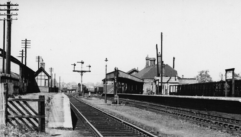
English: Stratford-on-Avon LMS, 1950 View east, towards Towcester and Blisworth, ex-Stratford-on-Avon & Midland Junction section of the LMSR: a rural link of the ex-Midland at Broom Junction at its western end across via Towcester to Ravenstone Wood Junction on the ex-Midland branch to Northampton from Oakley on the St Pancras - Sheffield main line north of Bedford; this eastern end was used for freight only, normal passenger trains going to Blisworth on the ex-LNWR WCML. |
||
| Date | |||
| Source | geograph.org.uk | ||
| Author | Walter-Dendy, deceased | ||
| Permission (Reusing this file) |
This file is licensed under the Creative Commons Attribution-Share Alike 2.0 Generic license. Attribution: Walter-Dendy, deceased
|

| Camera location | | View this and other nearby images on: OpenStreetMap |
|---|
_heading:270.00&language=en)
| Object location | | View this and other nearby images on: OpenStreetMap |
|---|
_heading:270.00&language=en)
File history
Click on a date/time to view the file as it appeared at that time.
| Date/Time | Thumbnail | Dimensions | User | Comment | |
|---|---|---|---|---|---|
| current | 20:02, 25 March 2017 | | 2,373 × 1,347 (861 KB) | G-13114 (talk | contribs) | {{Information |description={{en|1=View east, towards Towcester and Blisworth, ex-Stratford-on-Avon & Midland Junction section of the LMSR: a rural link of the ex-Midland at Broom Junction at its western end across to Ravenstone Wood Junction on the St... |
You cannot overwrite this file.
File usage on Commons
The following page uses this file: