File:Surveying the land (9102495711).jpg
Jump to navigation
Jump to search

Size of this preview: 800 × 531 pixels. Other resolutions: 320 × 213 pixels | 640 × 425 pixels | 1,024 × 680 pixels | 1,280 × 850 pixels | 2,100 × 1,395 pixels.
Original file (2,100 × 1,395 pixels, file size: 1.34 MB, MIME type: image/jpeg)
Captions
Captions
Add a one-line explanation of what this file represents
Summary
[edit].jpg&action=edit§ion=1)
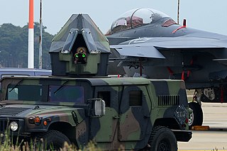
| Description | Airman 1st Class Jessie Ralls surveys the area around unexploded ordnance from atop an armored vehicle during a Phase II Exercise June 18, 2013, at Royal Air Force Lakenheath, England. The exercise tested Airmen on their skills and readiness to ensure they are prepared for real-world events. Ralls is a 48th Civil Engineer Squadron explosive ordnance disposal apprentice. (U.S. Air Force photo by Airman 1st Class Dana J. Butler) |
| Date | |
| Source | Surveying the land |
| Author | US Air Force from USA |
Licensing
[edit].jpg&action=edit§ion=2)
This image or file is a work of a U.S. Air Force Airman or employee, taken or made as part of that person's official duties. As a work of the U.S. federal government, the image or file is in the public domain in the United States.
|
 |
| This image was originally posted to Flickr by Official U.S. Air Force at https://flickr.com/photos/39513508@N06/9102495711. It was reviewed on 27 August 2016 by FlickreviewR and was confirmed to be licensed under the terms of the United States Government Work. |
File history
Click on a date/time to view the file as it appeared at that time.
| Date/Time | Thumbnail | Dimensions | User | Comment | |
|---|---|---|---|---|---|
| current | 21:48, 27 August 2016 | | 2,100 × 1,395 (1.34 MB) | Vanished Account Byeznhpyxeuztibuo (talk | contribs) | Transferred from Flickr via Flickr2Commons |
You cannot overwrite this file.
File usage on Commons
The following page uses this file:
.jpg&oldid=913047701)